

A plateau of granite peaks known as the Black Hills has towered over the high plains west of the Missouri River and east of the Rocky Mountains for millions of years. The Hills are covered with pine forests, which have thrived in the wetter conditions of elevations higher than the arid grasslands surrounding them. Their forested slopes appear dark when viewed from the surrounding plains, and have long offered refuge to humans and other species. Over centuries the Hills became central to the cultural, economic, and spiritual life of Lakota (Sioux), Cheyenne, and other Indigenous peoples in the area, who refused to cede them to the expanding United States or to private interests, which sought to claim and colonize as much of the high plains and Black Hills as seemed economically and militarily feasible. Despite the expansionist “Manifest Destiny” ideology promulgated by US politicians like Andrew Jackson and Henry Clay, and newspapermen like John L. O’Sullivan, who had coined the term, federal authorities recognized the local authority of “Indian Nations” in the 1851 Treaty of Fort Laramie, which delineated a “Great Sioux Reservation” west of the Missouri River.
This 1851 Treaty, which recognized Lakota claims to the Hills, remains in place, as the US Supreme Court confirmed in 1980. Yet others began to take interest in the extractable minerals and timber of the Hills as early as the mid-nineteenth century. Supported by some in the US government and military, speculators began to pursue what was seen as viable ranch-land and potential farmland in other parts of the Great Sioux Reservation by the 1870s. The Reservation was chipped away in pieces over the following century, by practices that included default judgments by presidents and congresses that sidestepped legal requirements to deal bilaterally with legitimate Lakota authorities. They reflected broader injustices in US Indian Policy over many decades, as well as the power and influence of many who saw the land and its resources not as sources of spiritual and cultural value but as commodities to be bought and sold. Over those decades Indigenous people lost control of the Black Hills to investors and speculators, with the blessing of successive US presidents and congresses, but have not conceded them, and continue to advocate for their return.
Maps, in particular, show how “settler-colonial” interests—seeking to remove certain groups from an area in order to make space for other groups—perceived the Black Hills and their surroundings. They show aspects of the territorial envisioning of US expansion, which included annexation and transformation of the Great Plains, including the perspectives of military reconnaissance and regular inventories of Indigenous lands falling under US control into the twentieth century. Maps show views held by economic interests which pushed that annexation and fueled that vision, which included attracting workers and settlers from other parts of an expanding US. Maps also show early US government attempts to assess some of the consequences of decades of mineral and timber extraction. Finally, they show settler-colonial attempts to compensate for the exhaustion of extractive industries such as mining and timber by finding other ways to commodify the Black Hills, in this case by promoting automobile-era tourism. This tourism often romanticized aspects of past Native life in the Hills, while at the same time dismissing and caricaturizing it as little more than nostalgia for another time.
While maps of the Great Plains and Black Hills had been made for centuries, possibly millennia, by those who lived there, the vast majority of surviving historic maps depicting them came out of the settler-colonial experience that began in earnest in the mid-nineteenth century. A survey of maps of the Black Hills from the that time through the mid-twentieth century offers a picture of successive views of land, territory, resources, and the developing mentality that drove this settler colonial experience – a visual expression and negotiation, on the ground, of manifest destiny. The documents and maps regarding the Black Hills that were widely printed and distributed in the nineteenth and twentieth centuries tend to reflect colonial perspectives. But those perspectives themselves varied greatly, and changed much over time. These maps and documents illustrate the process of colonization, not as a simple, decisive act of removal, but as a process involving a complicated mix of cultural attitudes and economic and political interests.
Essential Questions
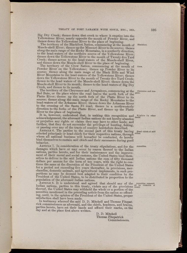
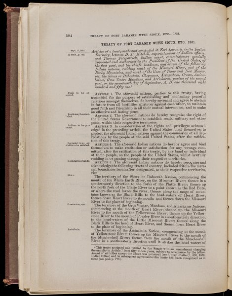
A Treaty signed at Fort Laramie on September 17, 1851 by government representatives from the United States and the “Sioux or Dacotah,” Cheyenne, Arapahoe, Crow, and Assiniboine nations, among others, sought to “establish and confirm peaceful relations” among all signatories, in the interest of preserving “an effective and lasting peace.” The westward movement of intensive US settlement and colonization had begun to strain resources such as the Buffalo on the North American Great Plains, on which the livelihoods of many of its native inhabitants depended. Anxiety and hostility resulted from this scarcity, and many US officials, not yet concerned with potential economic value in the area, sought to pacify the Plains’ Indigenous inhabitants, who had demonstrated the will to fight for control of their homelands, in the process of passing them by on the way to the richer lands for potential settlement such as California and Oregon on the Pacific Coast.
The Treaty recognized groups such as the Lakota and Cheyenne as “Indian nations,” whose status meant that US dealings with such nations must take the form of formal treaties like this one. Territorial boundaries were recognized for each of these nations, and these were written into the Treaty, with one caveat: “The aforesaid nations” would “hereby recognize the right of the United States Government to establish roads, military and other posts, within their respective territories.” The treaty also bound the United States and its citizens and government to “protect the aforesaid Indian nations against the commission of all depredations by the people of the said United States.” In exchange for “damages which have or may occur” as a result of “treaty stipulations” like the United States’ right to establish roads crossing Indian nations’ territories, and posts within them, the US government promised payments that would, in theory, help soften the effects of increasing resource scarcity.
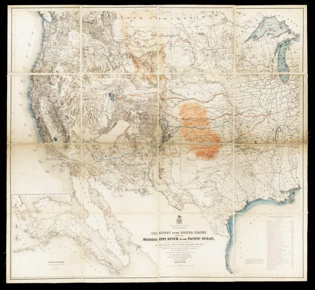
While the name Black Hills, or Paha Sapa in the Lakota language, had been in use for centuries, and had appeared in Indigenous maps for longer still, US officials and settler-colonists alike knew relatively little about the area until well into the nineteenth century. In the years after the Lewis and Clark expeditions, several maps, among them by Major Stephen Long (1923) and Henry Schenck Tanner (1822) suggest the common English-language practice of referring to the range in this area as “Black Hills” by the first decades of the nineteenth century, but their renderings of the hills are rough and amorphous. The Hills appear more locationally specific in a 1842 map by Colonel John C. Fremont, but did not appear in detail in US maps until the Pacific Railroad Survey began in earnest in the 1850s, when Lieutenant of Topographical Engineers Gouverneur K. Warren began mapping the area.
Warren’s 1855 maps published in Explorations in the Dacota Country clearly designated this area as the territory of the “Dacotas,” and wrote, four years after the treaty, that “very little is known as to the accurate geography and topography of the Crow country and Black Hills.” Not explicitly disputing Indigenous sovereignty of the territory, Warren did muse on the likelihood of eventual conflict in the area, acknowledging the “peaceful disposition of these tribes” could change, as they were likely to “become maddened by the encroachments of the white man.” Warren’s primary goal, however, and indeed his charge from the Secretary of War, was not “chastising Natives,” but assessing the best possible route for a Pacific Railroad.


A map initially drafted in 1857 and republished a decade later outlined Warren’s sense of the best routes for such a Railroad, routes relatively distant from the Black Hills, which could conceivably have left the Hills’ inhabitants in relative peace for some time, were there not competing interests representing settlers, prospectors, and others within the US military itself. Annotations for possible routes suggest that this copy of Warren’s map saw significant field use in the surveys as they progressed. Additional annotations suggest some of the economic hardships faced by many Lakota, Cheyenne, and others: Areas shaded in orange represent remaining buffalo ranges as observed in 1872. A few years later these would be almost gone.
Questions to Consider
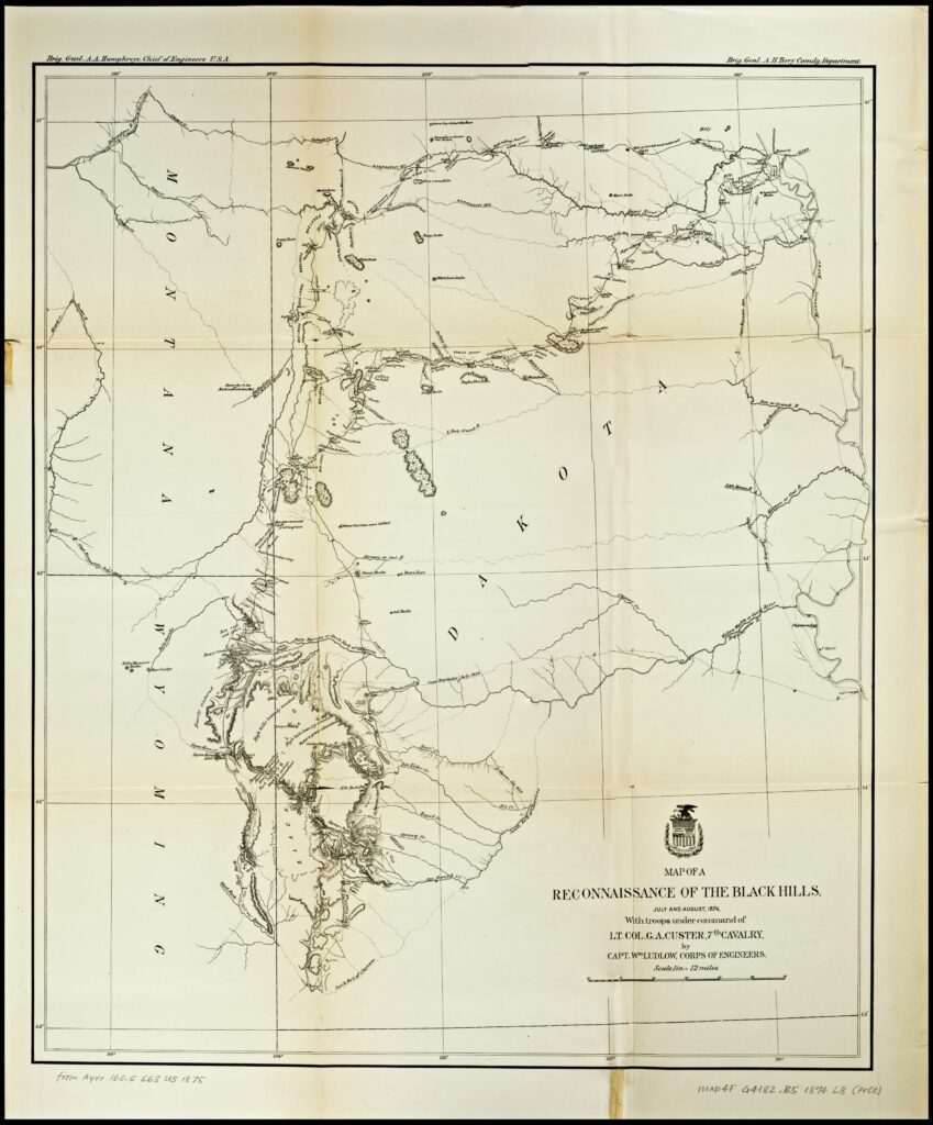
Whether the uneasy balance depicted in Warren’s Pacific Railroad Survey Map could have been maintained in any sort of long term is difficult to say. The 1851 Treaty, as well as a 1868 Treaty which reiterated many of the points of agreement made in 1851, unequivocally recognized the Black Hills as Indian land. Yet US government officials were themselves of divided opinion on Indian policy as well as western settlement. Some, like the flamboyant Colonel George Armstrong Custer, were committed not just to western expansion but to a sort of exuberant colonial boosterism, which had an additional effect of attracting newspaper headlines. In 1873, a year of market crashes and high unemployment in the east, many newspaper readers felt the pull of proclamations of great wealth to be found in the west.

Custer himself had been sent on an expedition to scout the area near the Black Hills for a potential US fort in 1873. This was itself legal under the Treaty provisions, even if Custer’s commanding officer, General Phil Sheridan, had only intended such a fort to “pacify” the area’s Indigenous residents, who, dismayed by US doublespeak and encouraged by charismatic local figures such as Red Cloud, had grown increasingly wary of both official and unofficial US Indian policy. But Custer, himself a charismatic booster, took the opportunity to order his Seventh Cavalry to intensively scout the Black Hills as well, one result of which was the production of this map, which shows routes not around the Hills, but through them. Custer’s most decisive action, however, was one to promote the idea that the Hills contained vast amounts of gold, which quickly found its way into newspapers, and prompted thousands of prospectors to descend on the Hills in the years to follow.
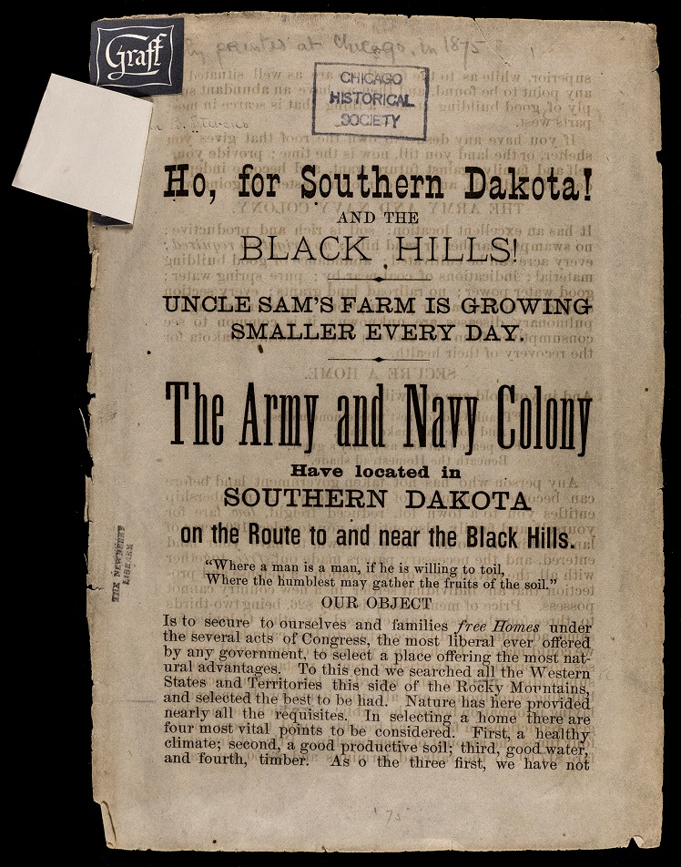
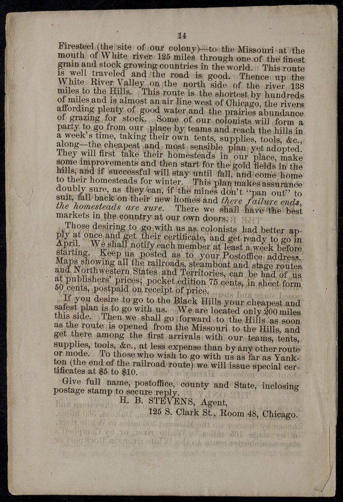
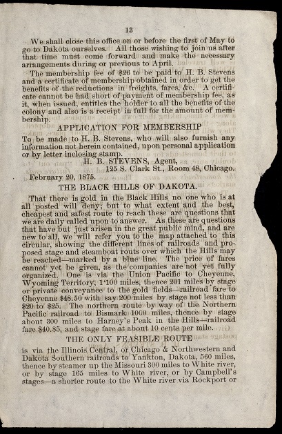
As soon as US newspapers had published accounts of gold in the Black Hills, land agents like Hiram Stevens sought to profit by recruiting colonists to settle in the area to benefit from its potential timber wealth, “good, productive soil,” and, in the case of the Hills themselves, gold, which “no one who is at all posted will deny.” The map in Stevens’s pamphlet promoted what he referred to as “the best, cheapest, and safest route” to the Hills from Chicago and points east. Besides the label “Black Hills,” the only other word appearing in that section of the map is telling: Gold.
While the US Army had a legal responsibility to honor its treaties and protect the Black Hills and their Indigenous populations from US settlement, US public opinion after Custer’s highly publicized expedition had quickly integrated the Hills into its colonial gaze. Otherwise reluctant officials like President Ulysses S. Grant felt pulled between treaty obligations and their sense of responsibility to their own constituents, and policy shifts reflected this. Custer’s Seventh Cavalry itself stopped protecting Indian lands from US settlement and began protecting the prospectors and miners who were flocking to the Hills in violation of the treaties, and who were often met with hostility by the Hills’ legal Lakota inhabitants. At this point the job of the US Army on the plains became one of compelling Indigenous parties to the treaties of 1851 and 1868 to relinquish their claims and to move to increasingly smaller reservations, by force if deemed necessary. The use of such force, and the resulting annihilation of Custer’s Cavalry by Lakota and Cheyenne warriors in 1876 at the Battle of the Little Bighorn, cemented this policy shift and galvanized the US public into demanding a course of outright removal, regardless of treaty obligations, a fire fueled by sensationalistic articles like one that appeared in Harper’s Weekly on July 22, 1876.
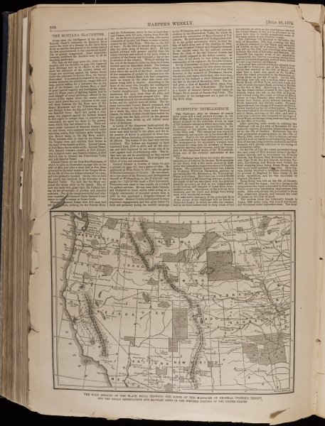
A map drawn to accompany this article illustrates, according to its caption, “The gold regions of the Black Hills, showing the scene of the massacre of General Custer’s Troops, and the Indian reservations and military posts in the western portion of the United States.” Despite official treaties stating otherwise, this privately-published map clearly claims the entire area south of the border with “British America” as US territory. It is also among the last published maps to depict the vast area between the twenty-seventh meridian and the Missouri River as a remaining vestige of the Great Sioux Reservation that had been delineated in 1851. The caption makes it clear: The Black Hills was now viewed as a US “gold region.”
Questions to Consider
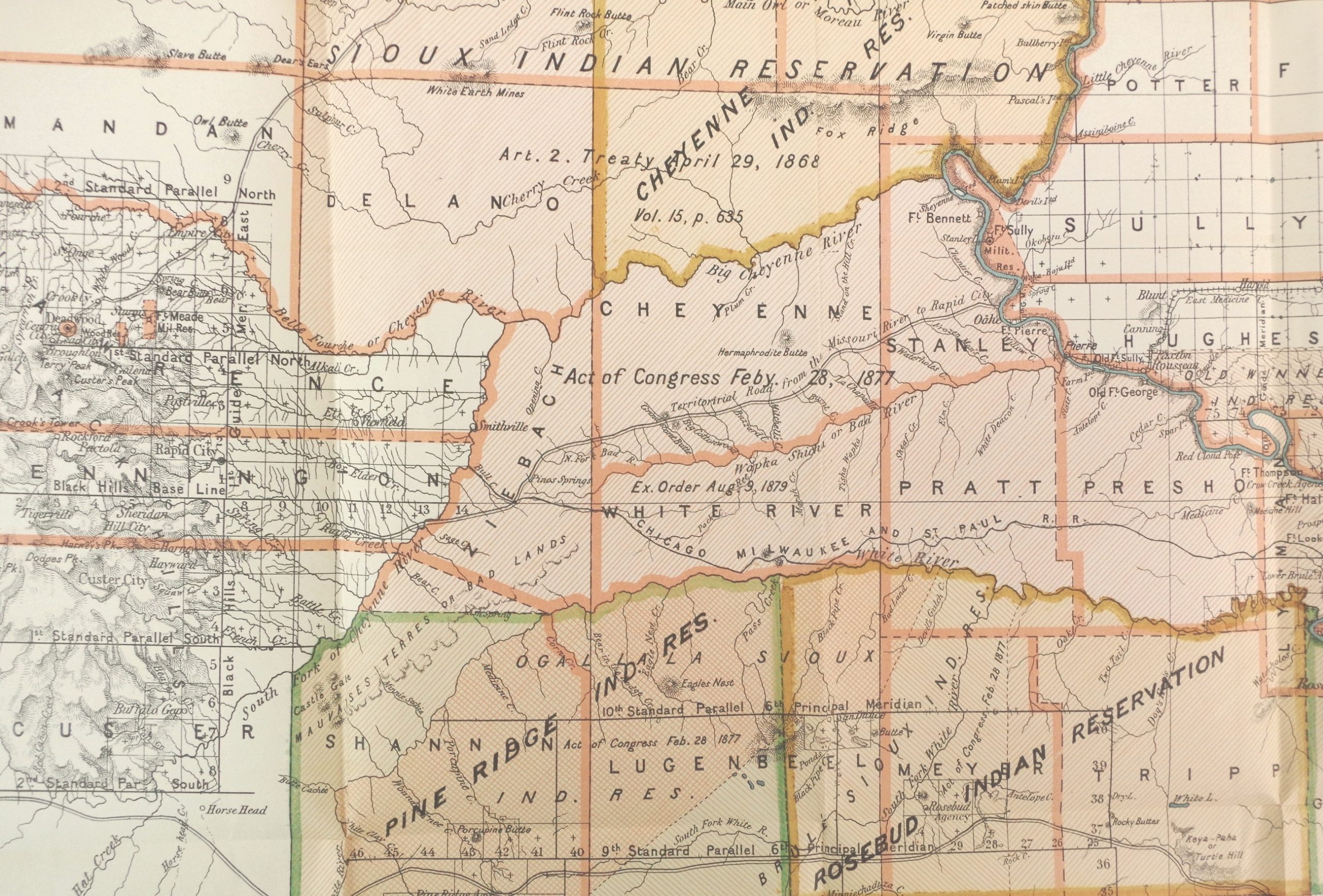
In the months and years after the Battle of the Little Bighorn, US public opinion had fallen decisively in favor of the outright removal of all Lakota, Cheyenne, and other Indigenous people from the Black Hills and their environs. In the 1870s and 1880s a series of “agreements” and acts of the US congress, made in violation of the treaties of 1851 and 1868 and without the assent or even knowledge of much of the area’s Indigenous inhabitants, claimed the Black Hills, along with much of the rest of the land that had been delineated in 1851, for the United States. These left only scattered reservations, to which many of the Hills’ inhabitant were forced to relocate.
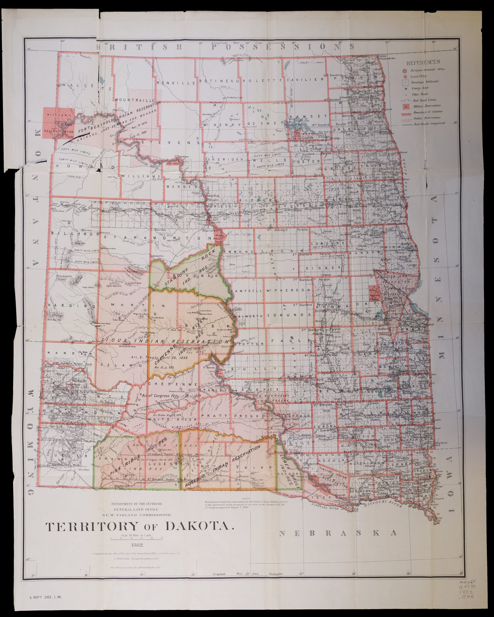
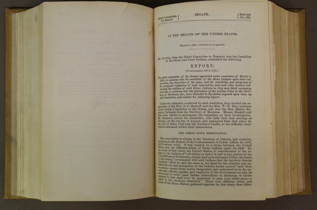
By this time official US maps of the area were drawn to frame US territorial divisions, and all official documentation came to be categorized by territorial, later state, confines. The Black Hills had traditionally been represented undivided and in the center of many Lakota and other Indigenous maps. Territorial US maps split them into two state jurisdictions and further divided them into new counties, as appear on an 1882 map published to accompany a report by US Senator Henry Laurens Dawes and the “Select Committee to Examine into the Conditions of the Sioux and Crow Indians.”

Even land on remaining reservations was not immune to being taken. Senator Dawes’s General Allotment Act of 1887, also known as “The Dawes Severalty Act,” dissolved local Indian governments and divided formerly communal land into private holdings, with the stated goal of assimilating and dispersing the land’s Indigenous populations into the larger US economy and culture, and thereby eliminating any sense of their “Indian-ness”. The practical effect of this in the former Great Sioux Reservation is demonstrated by a 1904 map “opening” the Rosebud Reservation, one of the last vestiges of the “Great Sioux Reservation” secured in the 1851 Treaty, to colonial settlement. Commercial land interests employed surveys and allotment maps like this to speed transfer of Indian lands to US investors and settler-colonists parcel by parcel.
Questions to Consider
By the 1890s the Black Hills had fallen almost entirely into the hands of US settler-colonists. In little more than a decade, much of its old-growth forests had been cut down, or burned over as a result of irresponsible logging. This was a pattern being repeated across the continent, with drastic effects not only on forest ecosystems, but on water quality and other concerns far beyond the forests that were being cut down. US President Grover Cleveland, advised by forester Bernhard Fernow, sought to establish a number of “forest reserves” that would preserve remaining timber stands, water supplies, and habitats in several damaged or threatened areas. In 1897 President Cleveland established the Black Hills Forest Reserve, with the aim of conserving what had not already been lost.
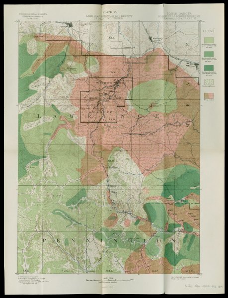
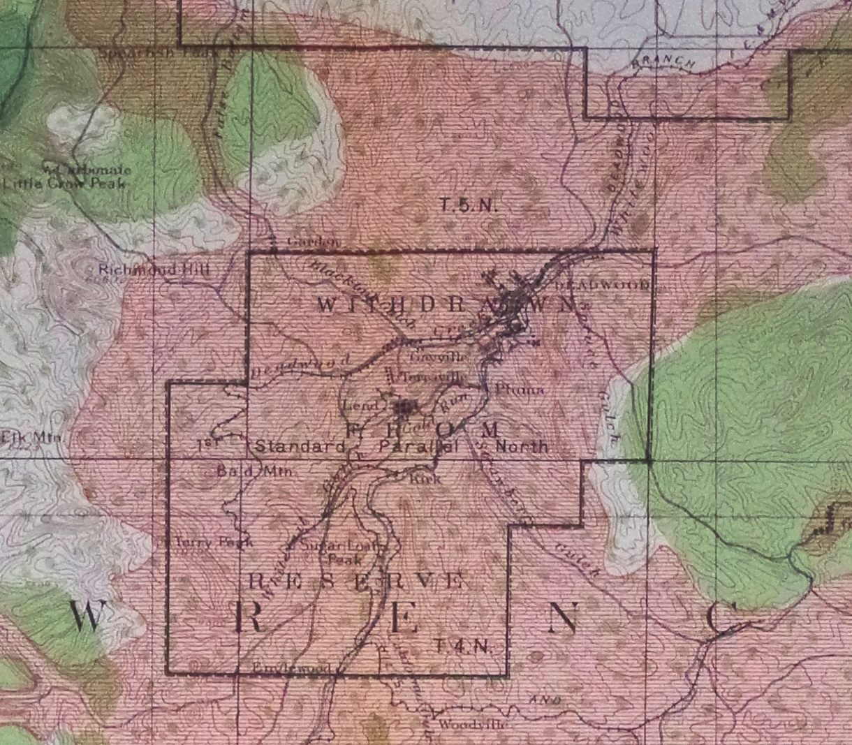
Representatives of mining and logging operations challenged such conservation policies from the beginning, and the status of such forest reserves, which was largely dependent on the political will to maintain them, was far from secure. An 1898 map of the Deadwood Quadrangle of the Black Hills National Forest showed the extent of cutover and burned-over lands in the vicinity of the mining town of Deadwood. According to the map only a few stands of dense forest remained in the area at that time. What did remain was classified as “merchantable timber,” suggesting even US conservation efforts understood forests largely as sources of valuable commodities. Notable in this map is the box at upper center: A large area has already, one year after the establishment of the Forest Reserve, been withdrawn from it.
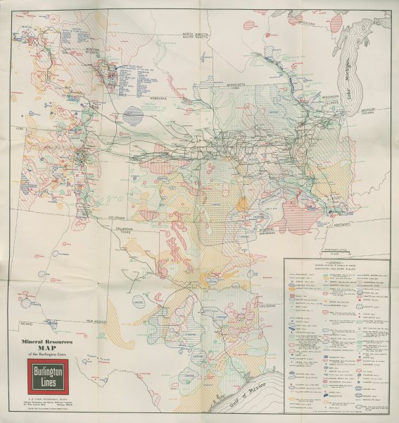
The Black Hills continued to be an important site for natural resource extraction in the twentieth century. A map drawn for a railroad company in 1940, to be included in its annual report to shareholders, illustrates the wide variety of mineral resources concentrated in the Hills. Indeed, in an area stretching from the Great Lakes to the Gulf Coast, the Mississippi River to the Rocky Mountains, the Black Hills, though not on the Burlington Railroad’s main line, show the greatest local concentration of such mineral resources on the entire map, forty-seven in total, from gold and tin to arsenic, graphite, lithium, and zinc. Many of these commodities would be particularly valuable for wartime industry, as the US entered the Second World War just a few months after the map was published.

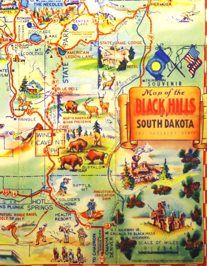
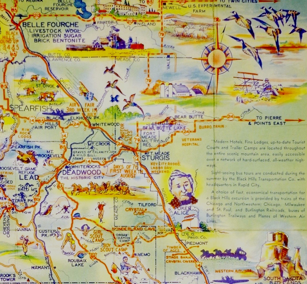
In the wave of prosperity that followed the Second World War, many in the US found themselves increasingly able to afford automobiles. Their newfound mobility allowed them not only to get to previously far-off places like the Black Hills, but to drive around within them, wherever roads had been built. This era saw the rise of a new industry in such places: Automobile tourism. The Black Hills, the easternmost vestige of the kind of rocky alpine environment that characterized other western ranges like the Rockies, were particularly appealing given their relative nearness to many population centers further east.
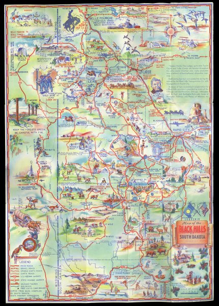
A tourist map from the late 1940s illustrates various “attractions” in the Black Hills accessible to or within view of public roads. These attractions constituted a new era in the colonization and commodification of the Hills: The marketing of an experience. That experience, as a unique commodity in itself, had to be envisioned, created, and embellished, and maps like this were grand advertisements. Illustrations included anything that might grab the attention of tourists, from rodeos and men hunting, fishing, and panning for gold to young women in bathing suits at poolside. Quirky local stories of figures like a cigar-smoking elderly woman known as Poker Alice romanticized the area’s brief moment of saloon culture in its early logging and gold mining days. New attractions like Mount Rushmore brashly announced US claims to sovereignty over the Hills, in this case by reshaping one of them into a sort of shrine to former US Presidents.
Finally, many attractions depicted on the back of the map in photographs, and in a few cases illustrated near the roads on its front side, recall the Hills before US colonization: Mountains, lakes, remaining stands of forests, and even a few buffalo, which by this time had been largely restricted to specialized ranches. Completing this picture on the lower right of the map are what appear to be three Lakota men on horseback, in ceremonial dress, viewing from a distance the action taking place in the hills.
Questions to Consider


Paul E. Cohen, Mapping the West: America’s Westward Movement 1524-1890, New York: Rizzoli, 2002.
John F. Freeman, Black Hills Forestry: A History, Boulder, CO: University Press of Colorado, 2015.
Edward Lazarus, Black Hills White Justice: The Sioux Nation versus the United States, 1775 to the Present, Lincoln: University of Nebraska Press, 1999.
Frederick C. Luebke, Frances W. Kaye, and Gary E. Moulton, eds., Mapping the North American Plains: Essays in the History of Cartography, Norman: University of Oklahoma Press, 1987.
Jeffrey Ostler, The Lakotas and the Black Hills: The Struggle for Sacred Ground, New York: Penguin, 2010.
Francis Paul Prucha, The Great Father: The United States Government and the American Indians, Lincoln: University of Nebraska Press, 1986.