When the United States gained its independence from Britain in 1783, the country was not yet the continental nation we know today. On maps, it stretched from the Atlantic seaboard to the Mississippi River, with most of these territories actually remaining under Native control. By 1848, wars and diplomatic negotiations with European powers and Mexico extended the United States to the Pacific. Even then, however, Indigenous people remained the main inhabitants and sovereigns of the trans-Mississippi West (the territories west of the Mississippi River). It took a Civil War (1861-1865) between the North and the South, more US-Indigenous warfare, as well as US attacks on Plains nations’ way of life to turn the United States into a transcontinental power.
From canals to railroads to automobiles, new transportation technologies also played a major role in the westward expansion of the United States and the making of the transcontinental nation. Each new mode of transportation facilitated the westward movement of migrants. Many of them—settlers from the East coast, European immigrants, and tourists—traveled voluntarily in search of better economic opportunities or for leisure. Others, like enslaved people and displaced Native Americans, moved west against their will.
The maps and texts in this Collection Essay convey the complex and often violent history of US westward expansion, as well as the diversity of migration experiences and migrants. The collection offers four case studies of US westward expansion and migrations from the era of canals and steamboats in the trans-Appalachian west after the 1810s, to the development of the antebellum Cotton Kingdom in the lower Mississippi Valley, to the age of transcontinental railroads in the late nineteenth century, and the democratization of the automobile in the 1920s and 1930s.
Please consider the following questions as you review the documents:
How did new transportation technologies transform the American landscape? What significance did this transformation have on land use and ownership over time?
Who traveled these routes and for what purposes?
How have class, race, and gender informed the history of transportation and travel?
Building the Erie Canal: Migration and the Forced Expulsion of Native Peoples in the North, 1810s-1840s
Natural waterways had long been the main transportation route in North America. Indigenous people had paddled lakes and rivers since times immemorial and located their villages and trading centers, like Chicago and Mackinac in the Great Lakes, along rivers and at the crossroads of waterways. When European settlers colonized North America starting in the sixteenth century, they followed in Indigenous footsteps. By contrast, the first half of the nineteenth century saw a series of innovations in transportation—the steamboat, canal, and railroad—which opened new land to non-Native settlement.
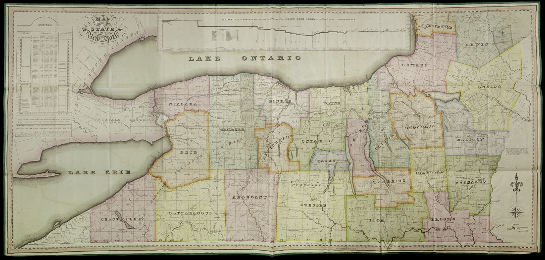
David H. Vance. Map of the Western Part of the State of New York, detail of map key (1823)
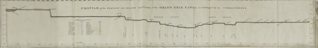
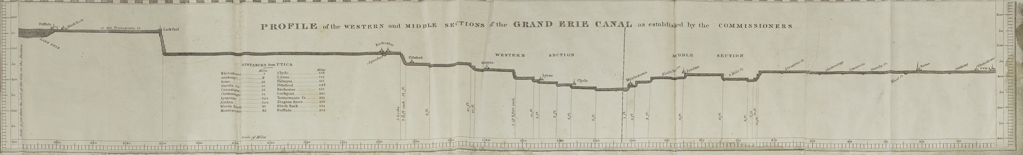
David H. Vance. Map of the Western Part of the State of New York, “Profile of the Western and Middle Sections of the Grand Erie Canal” showing the canal profile and locks (1823)
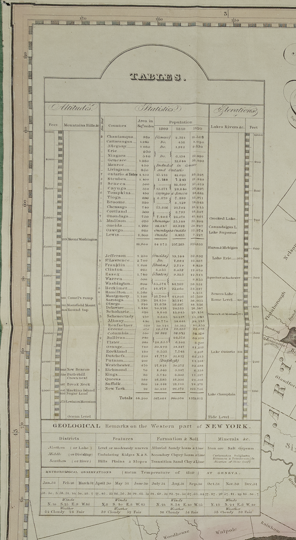
David H. Vance. Map of the Western Part of the State of New York, “Tables” showing the evolution of the population in western New York counties (1823)
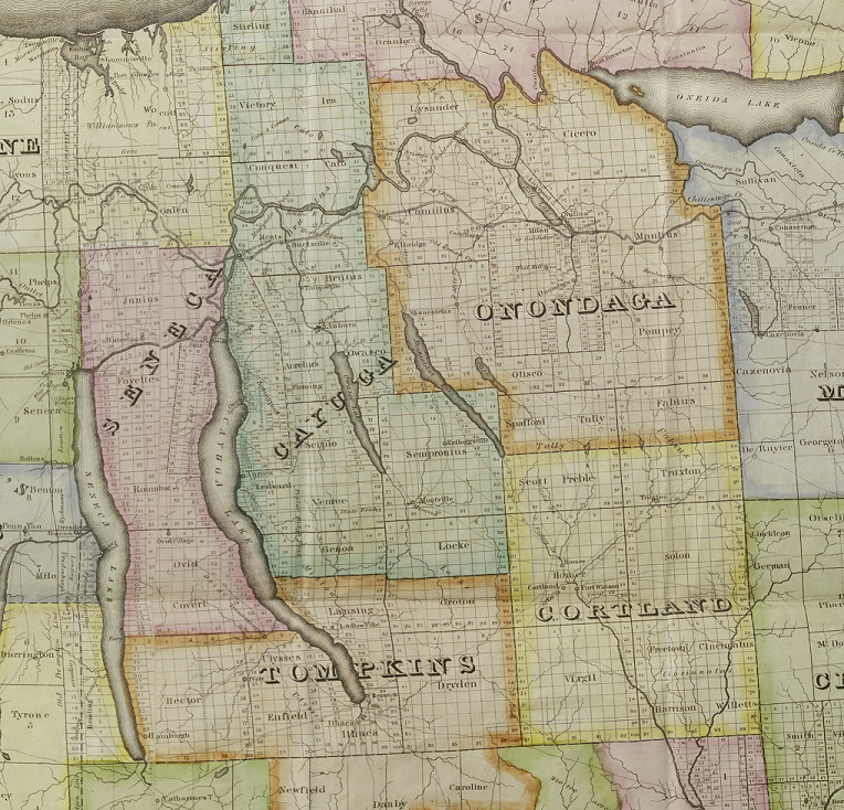
David H. Vance. Map of the Western Part of the State of New York, detail of counties named after the Haudenosaunee (1823)
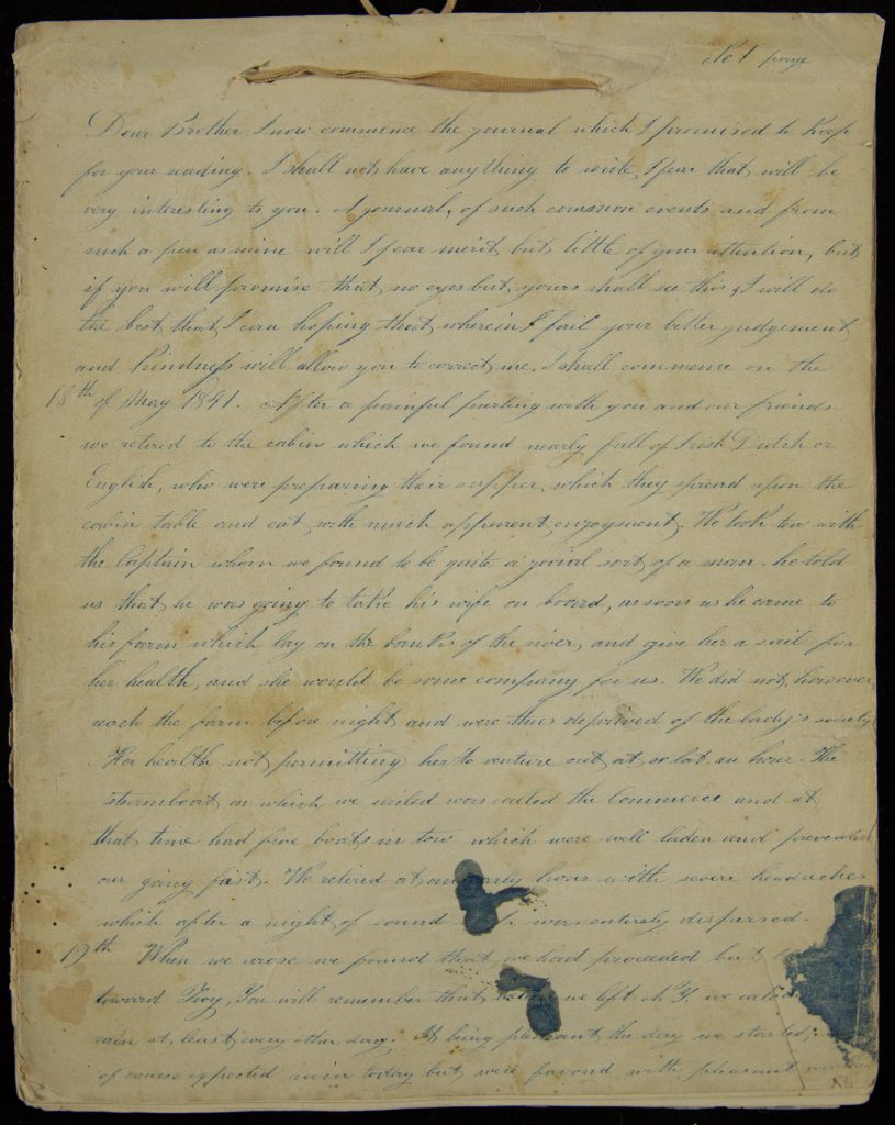
Connecting existing waterways, canals extended the possibilities for transporting settlers and goods. By 1837, 3,000 miles of canals linked the Atlantic seaboard to the Great Lakes and the Ohio and Mississippi Rivers and reduced the cost of transportation. Completed in 1825, the Erie Canal was a major technological feat. Stretching through upstate New York between Albany on the Hudson River in the east and Buffalo on Lake Erie in the west, it connected New York City on the Atlantic seaboard to the Great Lakes and played a major role in the growth of New York into the largest US metropolis in the nineteenth century. It cut travel time from Albany to Buffalo from two weeks by stagecoach to five days by flatboat, a flat-bottomed boat able to navigate the shallow waters of rivers and canals. The canal’s completion also resulted in a large migration of Euro-Americans from New England and New York to the Upper Midwest (Illinois, Wisconsin, and Michigan). The Sackett family, for instance, moved from Rhode Island to Illinois in 1841. Young Mary Sackett recounted her family’s migration in her journal, excerpted here.
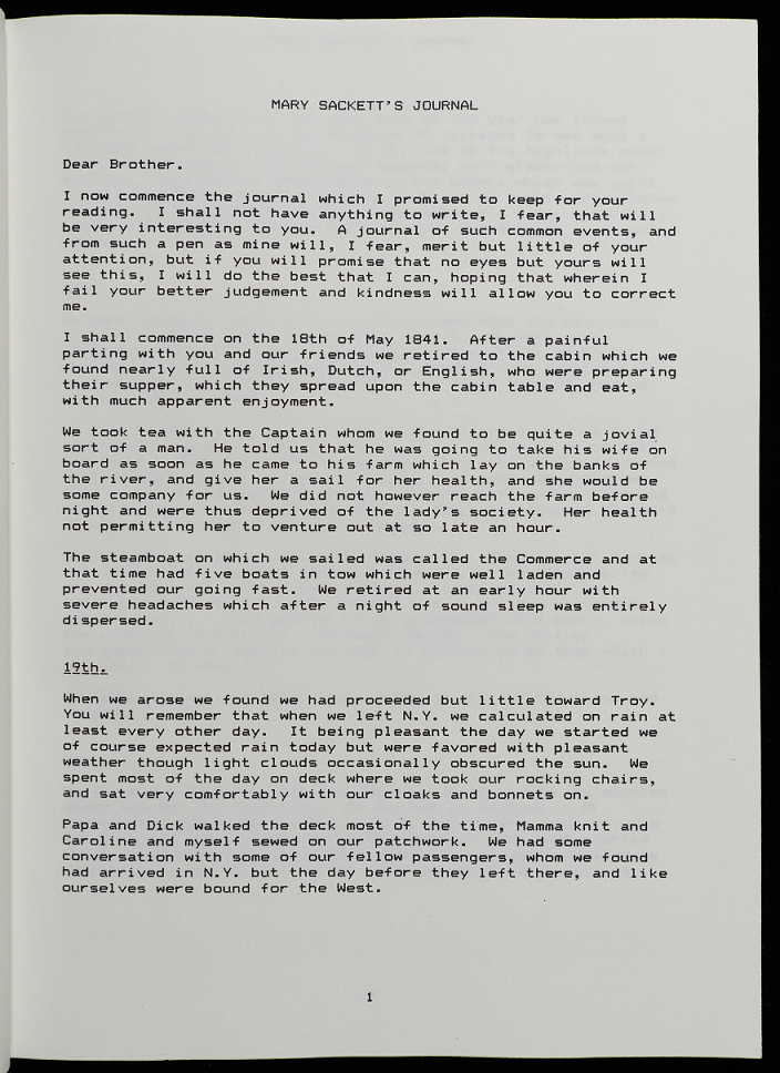
Dear Brother, I now commence the journal which I promised to keep for your reading. I shall not have anything to write I fear that will be very interesting to you. A journal, of such common events and from such a pen as mine will I fear merit but little of your attention, but if you will promise that no eyes but yours shall see this, I will do the best that I can hoping that wherein I fail your better judgement and kindness will allow you to correct me. I shall commence on the 18th of May 1841. After a painful parting with you and our friends we retired to the cabin which we found nearly full of Irish Dutch or English, who were preparing their supper, which they spread upon the cabin table and eat with much apparent enjoyment. We took tea with the Captain whom we found to be quite a jovial sort of a man. he told us that he was going to take his wife on board, as soon as he came to his farm which lay on the banks of the river, and give her a sail for her health, and she would be some company for us. We did not, however, reach the farm before night and were thus deprived of the lady’s society. Her health not permitting her to venture out at so late an hour. The steamboat on which we sailed was called the Commerce and at that time had five boats in tow which were well laden and prevented our going fast. We retired at an early hour with severe headaches which after a night of sound sleep was entirely dispersed.
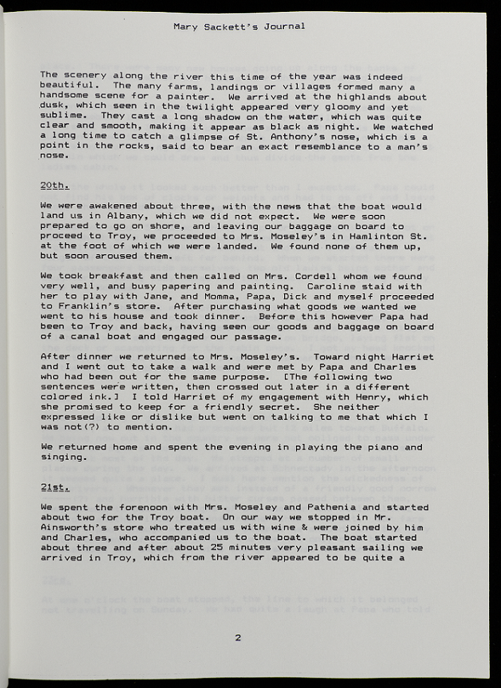
19th When we arose we found that we had proceeded but [[unknown]] toward Troy, You will remember that when we left N.Y. we [[unknown]] rain at least every other day. It being pleasant the day we started, of course expected rain today but were favored with pleasant weather [page 2] though light clouds occasionally obscured the sun. We spent most of the day on deck, where we took our rocking chairs, and sat very comfortably, with our cloaks and bonnets on. Papa and Dick walked the deck most of the time, Mama knit and Caroline and myself sewed on our patchwork. We had some conversation with some of our fellow [[passengers?]], whom we found had arrived in N.Y. but, the day before they left there, and like ourselves were bound for the west. The scenery along the river at this time of the year was indeed beautiful. The many farms, landings or villages formed as many a handsome scene for a frontier. We arrived at the highlands about dusk, which seen in the twilight appeared very gloomy and yet subblime. They cast a long shadow in the water, which was quite calm and smooth, making it appear as black as night. We watched a long time to catch a glimpse of the Anthony’s nose, which is a point in the rocks, said to bear an exact resemblance of a man’s Nose.
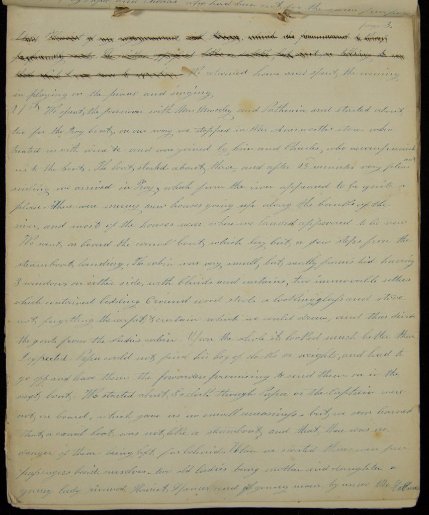
20th We were awakened about three, with the news that the boat would land in Albany, which we did not expect. We were soon prepared to go on shore, and leaving our baggage on board to proceed to Troy, we proceeded to Mrs Moseleys in Hamlinton St at the foot of which we were landed. We found none of them up, but soon aroused them. We took breakfast and then called on Mrs Cordell, whom we found very well, and busy preparing and painting. Caroline staid with her to play with June, and Mama Papa Dick and myself proceeded to Franklin’s store. After purchasing what goods we wanted we went to his house and took dinner. before this however, Papa had been to Troy and back, having seen our goods and baggage on board of a canal boat and engaged our [[unknown]]. After dinner we returned to Mrs Moseley’s. Towards night, Harriet and i went out to take a walk and were met by Papa and Charles who had been out for the same purpose. [page 3][[scratched out text]] [[scratched out text]] [scratched out text]] We returned home and spent the evening in playing on the piano and singing.
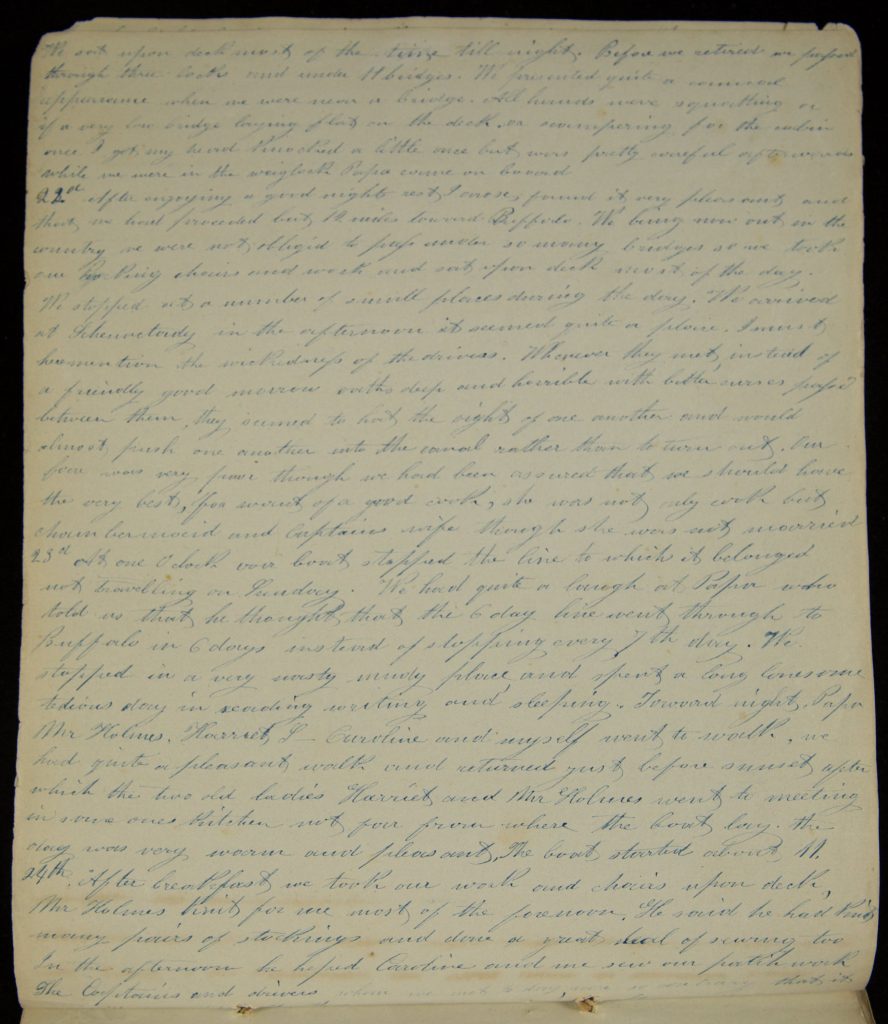
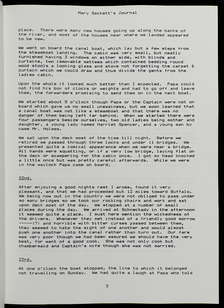
21st We spent the forenoon with Mrs Moseley and Catherine and started about two for the Troy boat, on our way we stopped in Mr [[Amisworth’s?]] store who treated us with wine [[unknown]] and were joined by him and Charles, who accompanied us to the boat. The boat started about three, and after 25 minutes very pleasant sailing we arrived in Troy, which from the river appeared to be quite a place. There were many new houses going up along the banks of the river, and most of the houses near where we landed appeared to be new. We went on board the canal boat which lay but a few steps from the steamboat landing. The cabin was very small, but neatly furnished having 3 windows on either side, with blinds and curtains, two immovable settees which contained bedding carved wood stools a looking glass and stove not forgetting the carpet curtain which we could draw, and thus divide the gents from the ladies cabin. Upon the whole it looked much better than I expected. Papa could not find his box of docks or weights, and had to go off and leave them the forwarders promising to send them on in the next boat. We started about 5 o’clock though Papa or the Captain were not on board, which gave us a no small uneasiness, but we soon learned that a canal boat was not like a steamboat and that there was no danger of them being left far behind. When we started there were four passengers beside ourselves, two old ladies being mother and daughter a young lady named Harriet Spencer and a young man by name Mr Holmes [page 4] We sat upon deck most of the time till night. Before we retired we passed through three locks and under 11 bridges. We presented quite a comical appearance when we were near a bridge. All hands were squatting or if a very low bridge laying flat on the deck or scampering for the cabin once I got my head knocked a little once but was pretty careful afterwards[.] While we were in the weighlock Papa came on board
22nd after enjoying a good nights rest I arose; found it very pleasant and that we had proceeded but 12 miles toward Buffalo. We being now out in the country we were not obliged to pass under so many bridges so we took our rocking chairs and work and sat upon deck most of the day. We stopped at a number of small places during the day. We arrived at Schenectady in the afternoon it seemed quite a place. I must here mention the wickedness of the drivers. Whenever they met instead of a friendly good morrow [[unknown]] and horrible with bitter curses passed between them, they seemed to hate the sight of one another and would almost push one another into the canal rather than to turn out. Our fare was very poor though we had been assured that we should have the very best, for [[unknown]] of a good cook, she was not only cook but [[unknown]] [[unknown]] and Captain’s wife though she was not worried.
23rd At one o’clock our boat stopped the line to which it belonged not travelling on Sunday. we had quite a laugh at Papa who told us that he thought that the 6 day line went through to Buffalo in 6 days instead of stopping every 7th day. We stopped in a very nasty [[mudy?]] place and spent a long lonesome tedious day in reading writing and sleeping. Toward night, Papa Mr Holmes, Harriet, L- Caroline and myself went to walk, we had quite a pleasant walk and returned just before sunset after which the two old ladies Harriet and Mr Holmes went to meeting in a [[unknown]] ones kitchen not far from where the boat lay. The day was very warm and pleasant, The boat started about 11.
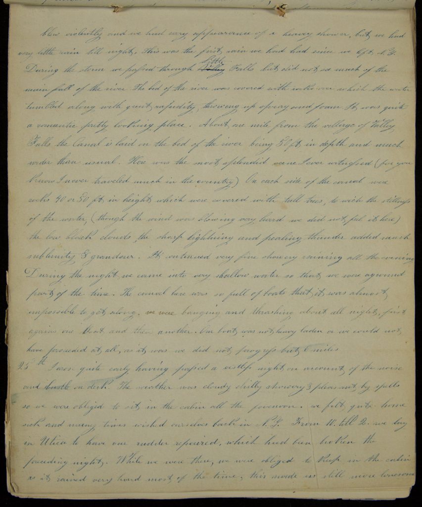
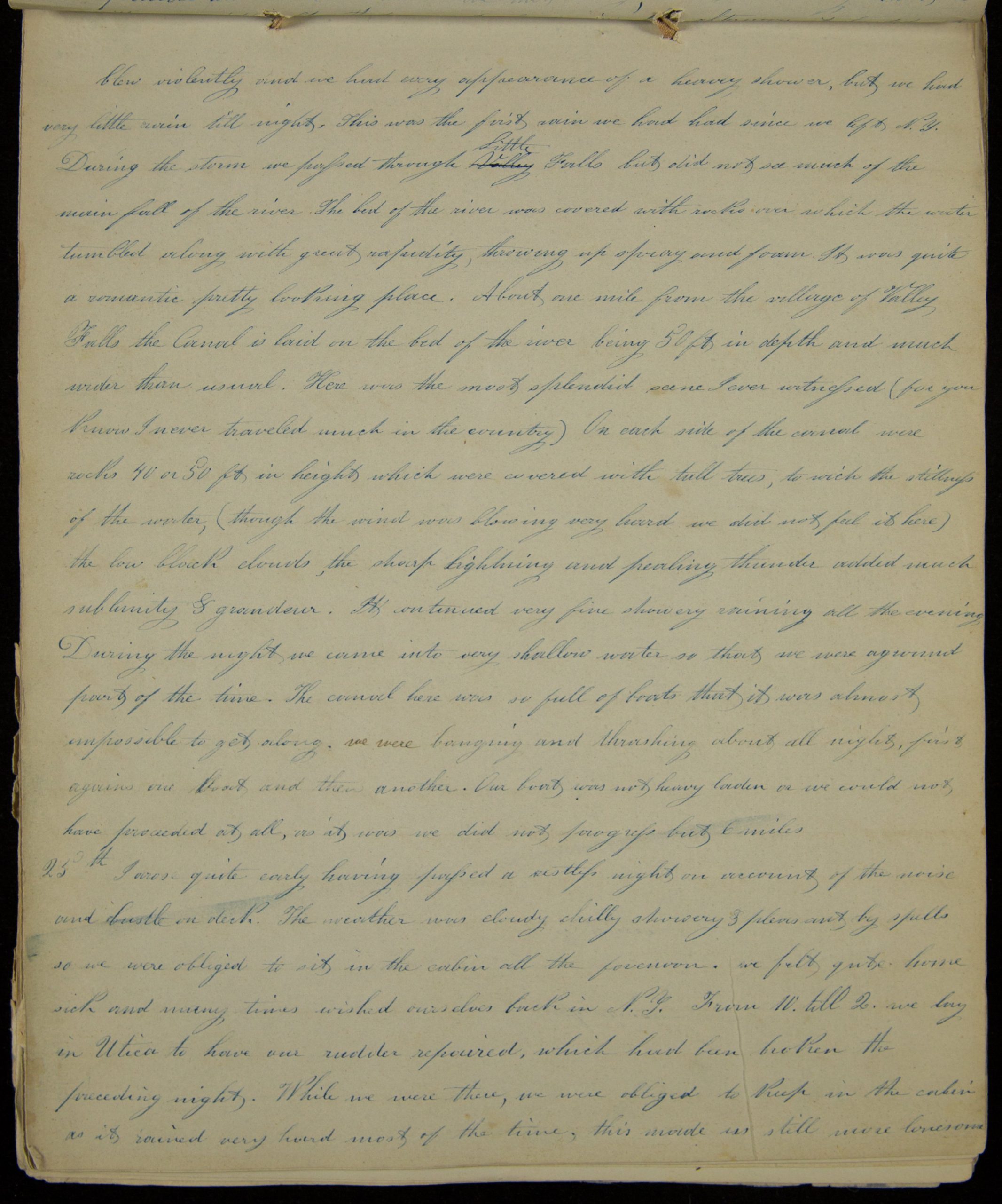
24th After breakfast we took our walk and chairs upon the deck, Mr Holmes knit for us most of the forenoon. He said he had knit many pairs of stockings and done a great deal of sewing too[.] In the afternoon he helped Caroline and me sew our patchwork[.] The Captain’s and drivers, whom we met to [[unknown]], were so contrary that its [page 5] blow violently and we had every appearance of a heavy shower, but we had very little rain till night. This was the first rain we had had since we left N.Y. During the storm we passed through Little Falls but did not see much of the main fall of the river. The bed of the river was covered with rocks over which the water tumbled along with great rapidity, throwing up spray and foam. It was quite a romantic pretty looking place. About one mile from the village of Valley Falls the Canal is laid on the bed of the river being 50 ft in depth and much wider than usual. Here was the most splendid scene I ever witnessed (for you know i never traveled much in the country) On each side of the canal were rocks 40 or 50 ft in height which were covered with tall trees, to which the stillness of the water, (though the wind was blowing very hard we did not feel it here) the low black clouds, the sharp lightning and pealing thunder added much sublimity grandeur. It continued very fine showery raining all the evening During the night we came into very shallow water so that we were aground part of the time. The canal here was so full of boats that it was almost impossible to get along, we were banging and thrashing about all night, first against one boat and then another. Our boat was not heavy laden or we could not have proceeded at all, as it was we did not progress but 6 miles[.]
25th I arose quite early having passed a restless night on account of the noise and bustle on deck. The weather was cloudy chilly showery and pleasant by spells so we were obliged to sit in the cabin all the forenoon. we felt quite home sick and many times wished ourselves back in N.Y. From 10 till 2 we lay in Utica to have our rudder repaired, which had been broken the preceding night. While we were there, we were obliged to keep in the cabin as it rained very hard most of the time, this made us still more lonesome [page 6]
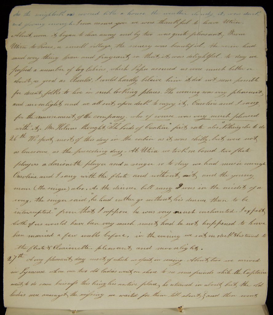
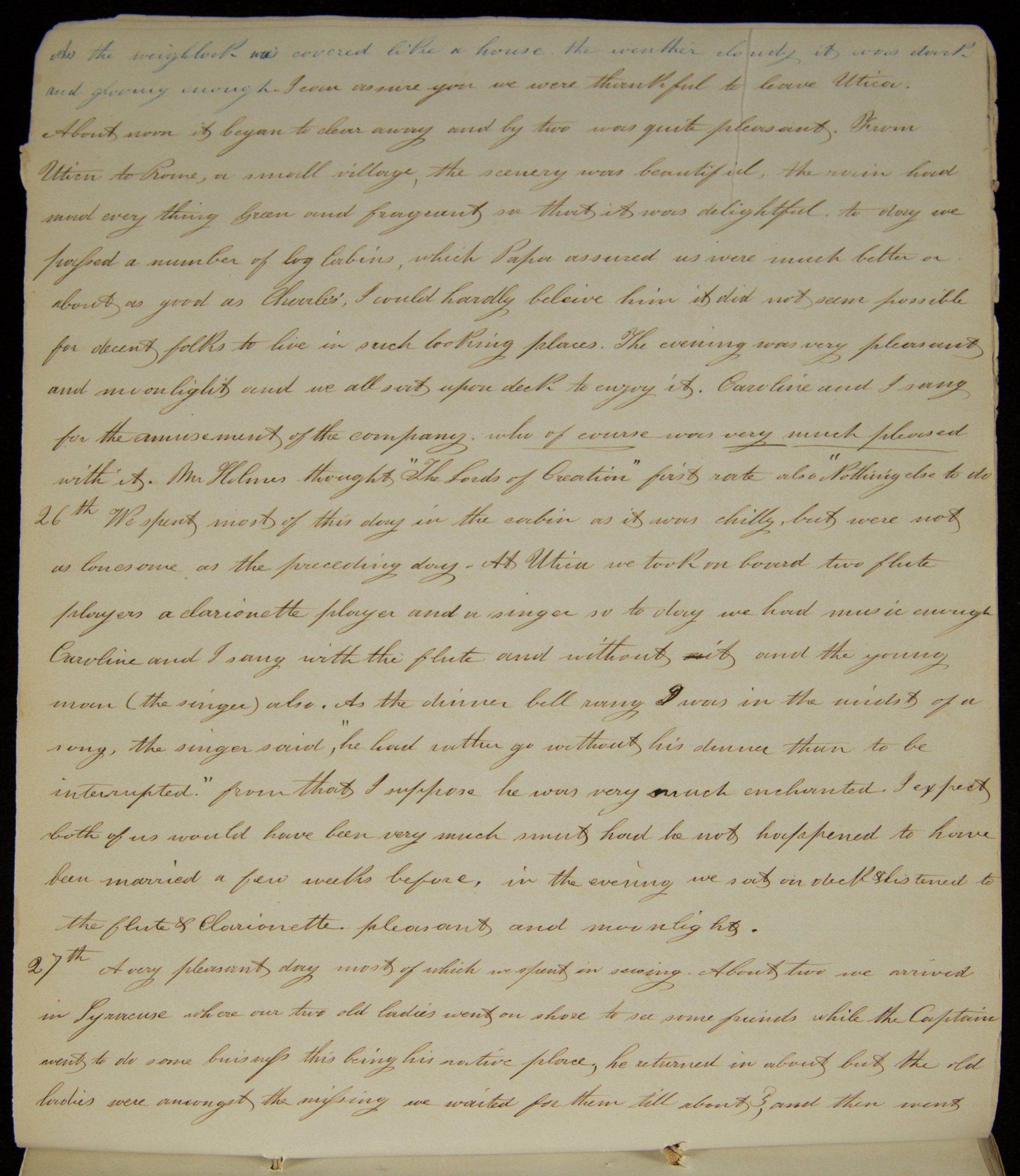
As the weighlock was covered like a house. the weather cloudy it was dark and gloomy enough. I can assure you we were thankful to leave Utica. About noon it began to clear away and by two was quite pleasant. From Utica to Rome, a small village, the scenery was beautiful, the rain had made ever thing green and fragrant so that it was delightful. to day we passed a umber of log cabins, which Papa assured us were much better or about as good as Charles’, I could hardly believe him it did not seem possible for decent folks to live in such looking places. The evening was very pleasant and moonlight and we all sat upon deck to enjoy it. Caroline and I sang for the amusement of the company who of course was very much pleased with it. Mr Holmes thought “The Lords of Creation” first rate and also “Nothing else to do”[.]
26th We spent most of this day in the cabin as it was chilly, but were not as lonesome as the preceding day. At Utica we took on board two flute players a clarionette player and a singer so today we had music enough Caroline and I sang with the flute and without it and the young man (the singer) also. As the dinner bell rang I was in the midst of a song, the singer said, “he had rather go without his dinner than to be interrupted.” From that I suppose he was very much enchanted. I expect both of us would have been very much smit had he not happened to have been married a few weeks before, in the evening we sat on deck listened to the flute Clarionette. pleasant and moonlight.
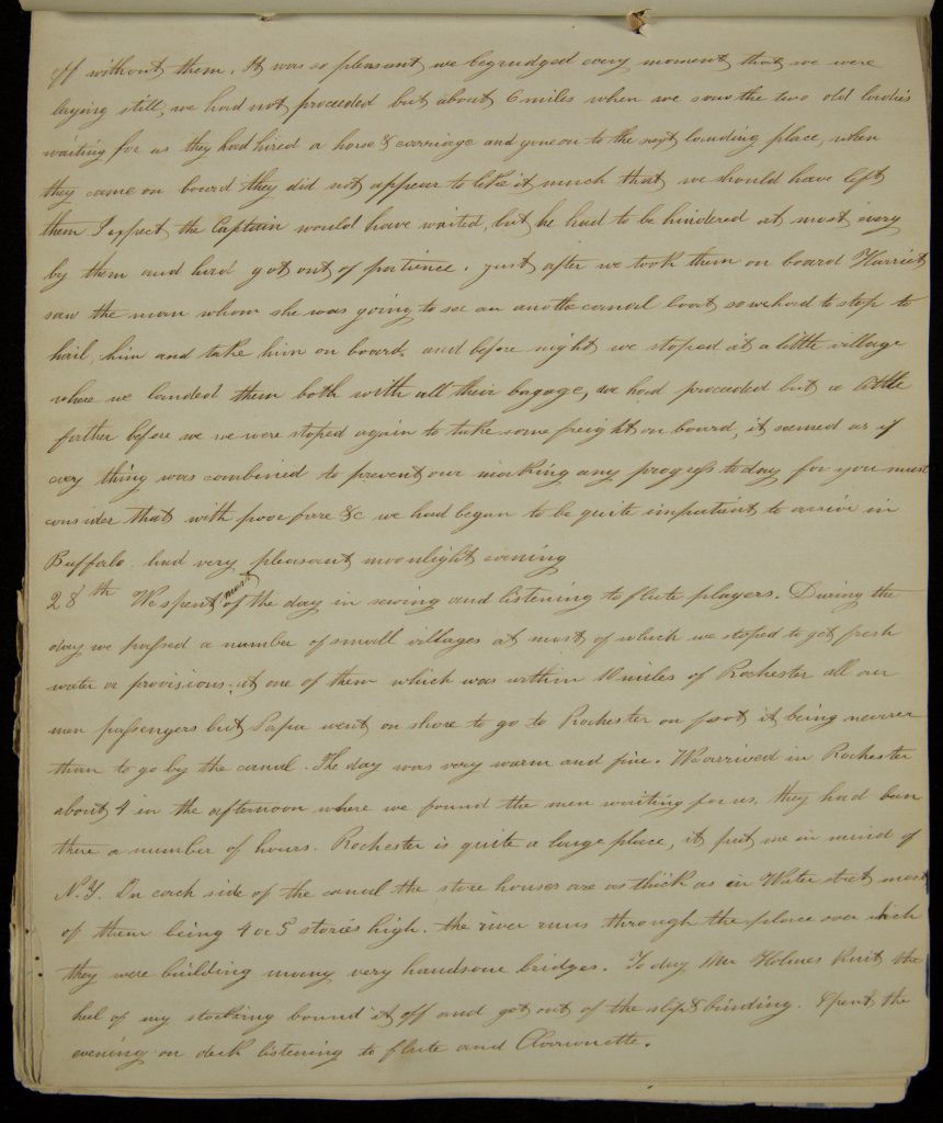
27th A very pleasant day most of which we spent in sewing. About two we arrived in Syracuse where our two old ladies went on shore to see some friends while the Captain went to do some business this being his native place, he returned in about but the old ladies were amongst the missing we waited for them till about 3, and then went [page 7] off without them. It was so pleasant we begrudged every moment that we were laying still, we had not proceeded but about 6 miles when we saw the two old ladies waiting for us they had hired a horse carriage and gone on to the next landing place, when they came on board they did not appear to like it much that we should have left them. I expect the Captain would have waited, but he had to be hindered at most very by them and had just got out of patience. Just after we took them on board Harriet saw the man whom she was going to see on another canal boat so we had to stop to hail him and take him on board and before night we stopped at a little village where we landed them both with all their baggage, we had proceeded but a little further before we were stoped again to take some freight on board, it seemed as if every thing was combined to prevent our making any progress today for you must consider that with [[poor fare?]] we had begun to be quite impatient to arrive in Buffalo had very pleasant moonlight evening[.]
28th We spent most of the day in sewing and listening to flute players. During the day we passed a number of small villages at most of which we stoped to get fresh water or provisions at one of them which was within 10 miles of Rochester all our men passengers but Papa went on shore to go to Rochester on foot it being nearer than to go by the canal. The day was very warm and fine. We arrived in Rochester about 4 in the afternoon where we found the men waiting for us, they had been there a number of hours. Rochester is quite a large place, it puts me in mind of N.Y. On each side of the canal the store houses are as thick as in Water street most of them being 4 or 5 stories high. the river runs through the place over which they were building many very handsome bridges. Today Mr Holmes knit the heel of my stocking bound it off and got out of the slip and binding. Spent the evening on deck listening to flute and Clarionette.
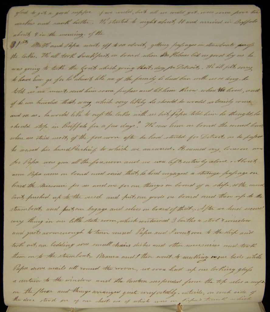
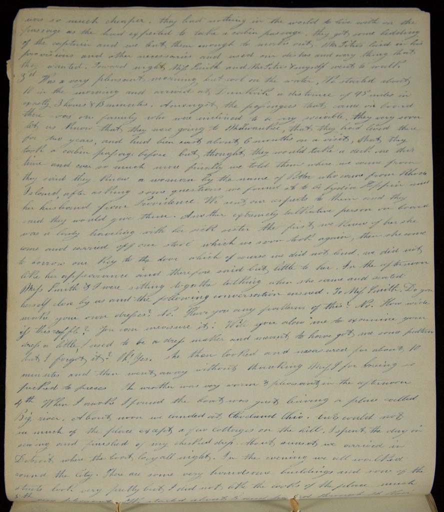
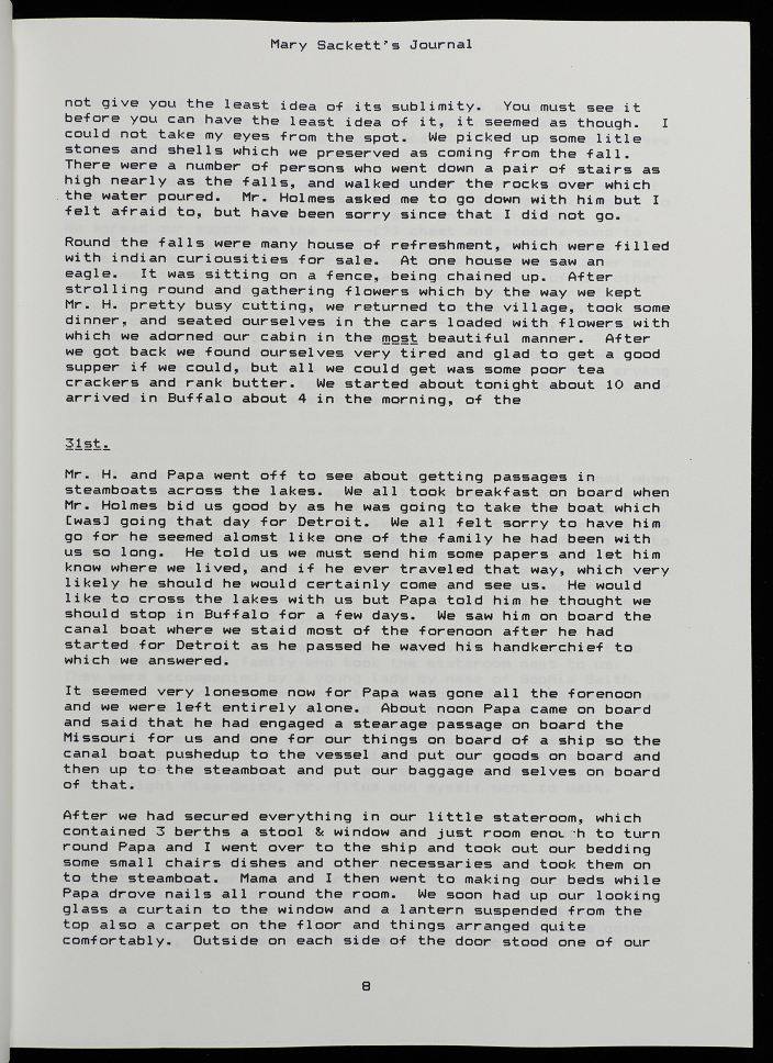
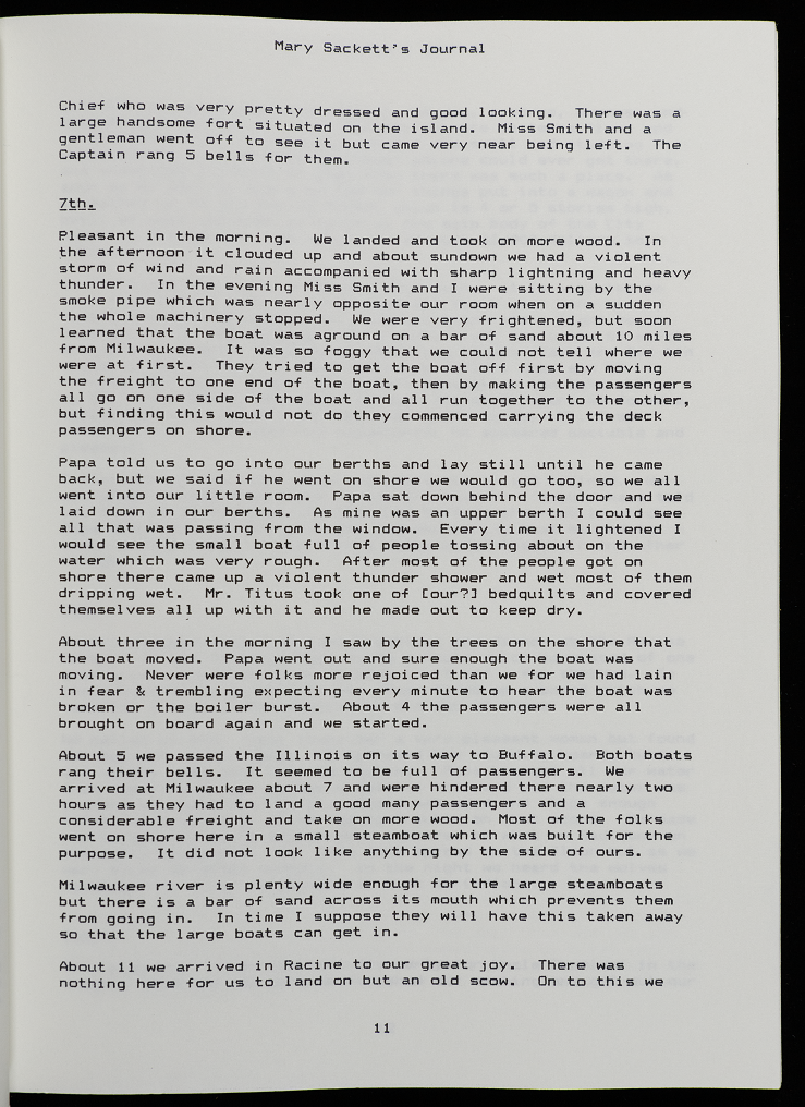
[page 10] … We started to night about 10 and arrived in Buffalo about 4 in the morning of the 31st Mr H and Papa went off to see about getting passages in steamboats [[unknown]] the locks. We all took breakfast on board when Mr Holmes bid us good by as he was going to take the boat which going that day for Detroit. We all felt sorry to have him go for he seemed almost like one of the family he had been with us so long, he told us “we must send him some [[unknown]] and let him know where we lived, and if he ever traveled that way which very likely he should he would certainly come and see us. he would like to cross the locks with us but Papa told him he thought he should stay in Buffalo for a few days.” We saw him on board the canal boat where we staid most of the forenoon after he had started for Detroit as he passed he waved his handkerchief to which we answered. It seemed very lonesome now for Papa was gone all the forenoon and we were left entirely alone. About noon Papa came on board and said that he had engaged a stearage passage on board the Missouri for us and one for our things on board of a ship, so the canal boat pushed up to the vessel and put our goods on board and then up to the steamboat and put our bagage and selves on board of that. After we had secured every thing in our little state room, which contained 3 berths a stool + window and just room enough to turn round Papa and I went over to the ship and took out our bedding some small chairs dishes and other necessaries and then on to the steamboat. Mama and I then went to making our beds while Papa drove nails all round the room, we soon had up our looking glass a curtain to the window and the curtain suspended from the top also a carpet on the floor and things arranged quite comfortably… [page 12] they had nothing in the world to live with on the passage as the had expected to take a cabin passage. they got some bedding of the captain and we but then enough to make out. Mr Titus laid in his provisions and other necessaries and used our dishes and every thing that they wanted. Toward night Miss Smith and Mr Titus myself went to walk[.]
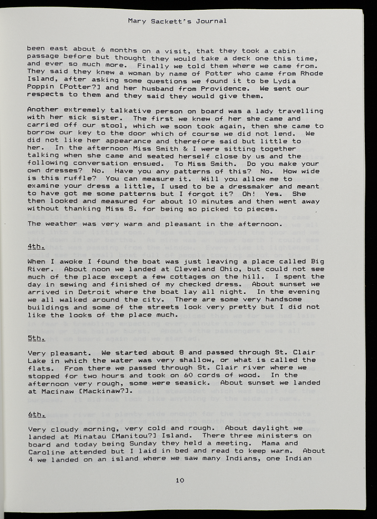
3rd Was a very pleasant morning but cool on the water, We started about 10 in the morning and arrived at Dunkirk a distance of 45 miles in exactly 3 hours 18 minutes. Amongst the passengers that come on board there was one family who were inclined to be very sociable, they very soon let us know that they were going to Milwaukee, that they had lived there for two years, and had been east about 6 months on a visit, that they took a cabin passage before but thought they would take a deck on this time and ever so much more. finally we told them where we come from they said they knew a woman by the name of Potter who came from Rhode Island, after asking some questions we found it to be Lydia [[Koppin?]] and her husband from Providence. We sent our respects to them and they said they would give them. Another extremely talkative person on board was a lady traveling with her sick sister the first we knew of her she came and carried off our stool which we soon took again, then she came to borrow our key to the door which of course we did not lend. we did not like her appearance and therefore said but little to her. In the afternoon Mrs Smith I were sitting together talking when she came and seated herself close by us and the following conversation ensued. To Mrs smith. Do you make your own dresses? No. Have you any patterns of this? No. How wide is this ruffle? You can measure it. Will you alow me to examine your dress a little, I used to be a dress maker and meant to have got me some patterns but I forgot it? Oh! Yes. She then looked and measured for about 10 minutes and then went away without thanking Miss S for being so picked to pieces. The weather was very warm pleasant in the afternoon[.]
4th When I woke I found the boat was just leaving a place called Big river. About noon we landed at Cleveland Ohio. but could not see much of the place except a few cottages on the hill. I spent the day in sewing and finished off my checked dress. About sunset we arrived in Detroit where the boat lay all night. In the evening we all walked round the City. There are some very handsome buildings and some of the streets look very pretty but I did not like the looks of the place much.
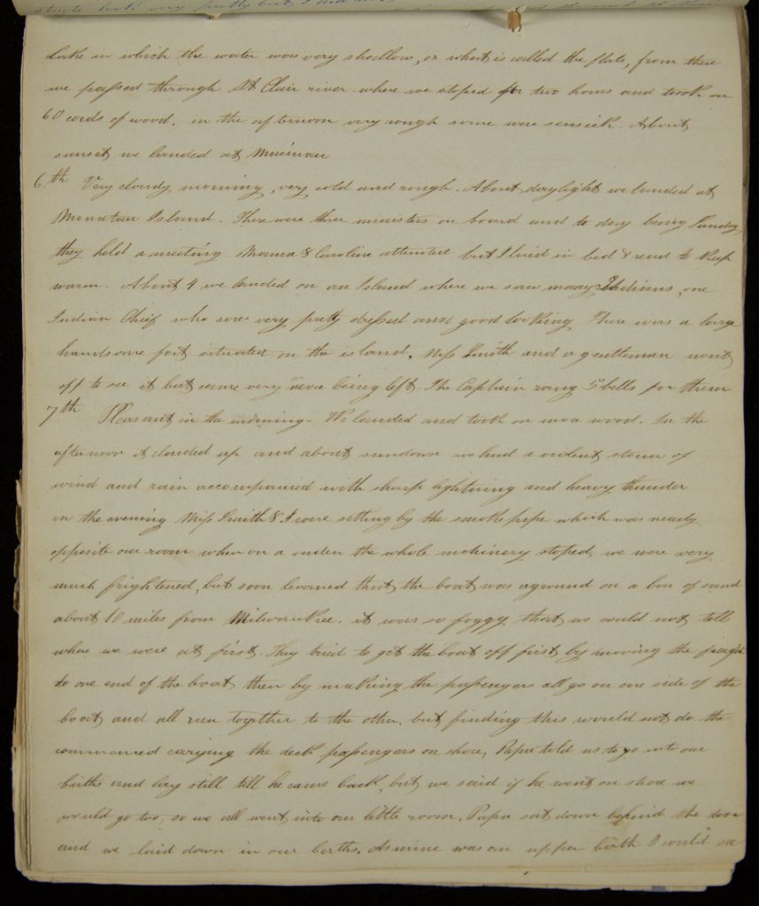
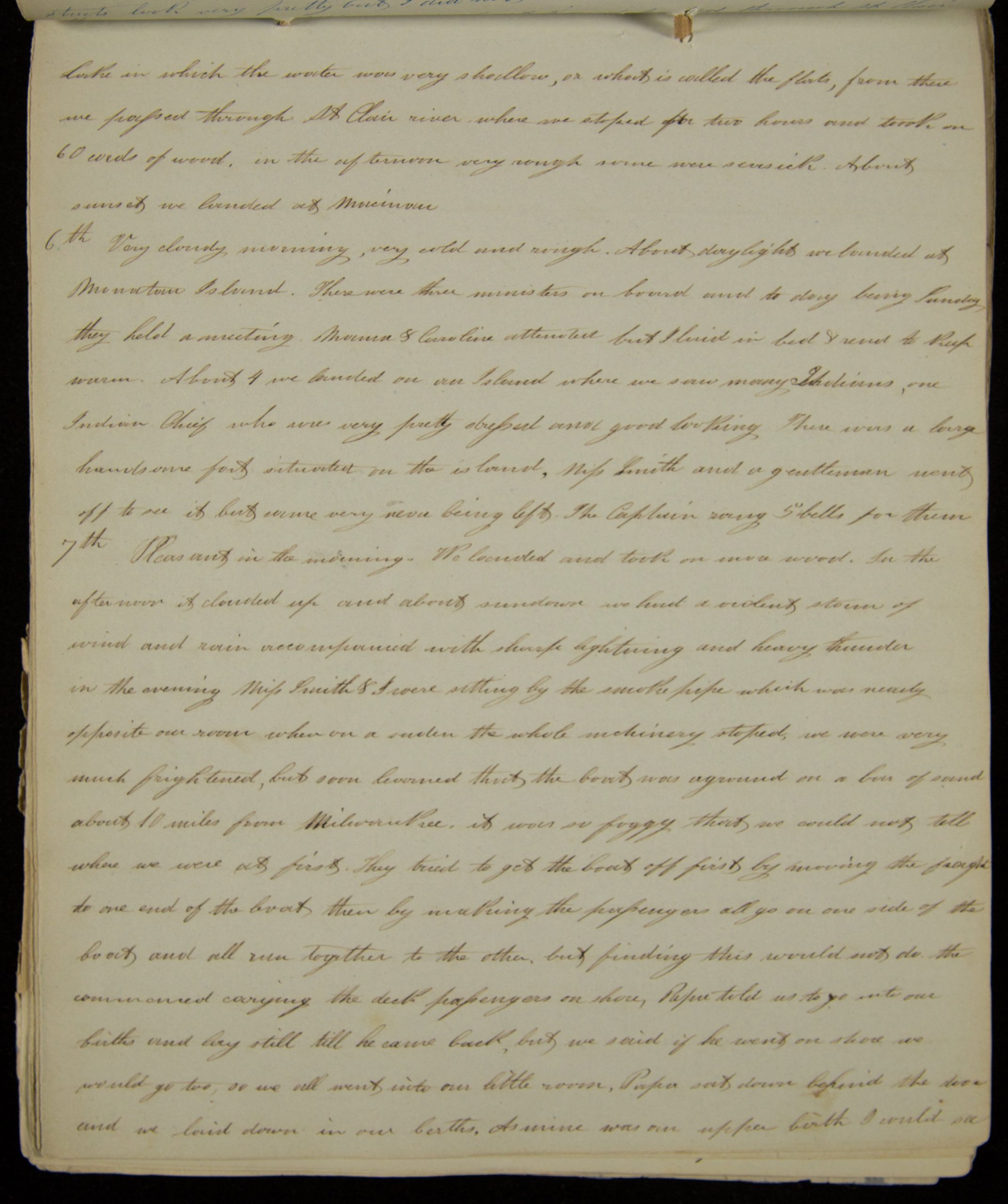
5th very pleasant. We started about 8 and passed through St Clair [page 13] lock in which the water was very shallow, or what is called the flats, from there we passed through St Clair river where we stoped for two hours and took on 60 cords of wood. in the afternoon very rough some were seasick. About sunset we landed at Macinaw[.]
6th Very cloudy morning, very cold and rough. About daylight we landed at Manitou Island. There were three ministers on board and to day being Sunday they held a meeting. Mama Caroline attended but I laid in bed read to keep warm. About 4 we landed on an Island where we saw many Indians, one Indian Chief who was very pretty dressed and good looking. There was a large handsome fort situated on the island, Miss Smith and a gentlemen went off to see it but came very near being left. The Captain rang 5 bells for them[.]
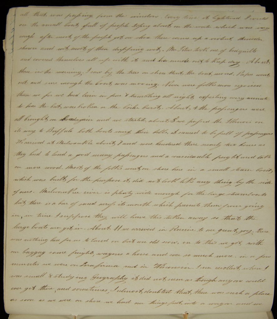
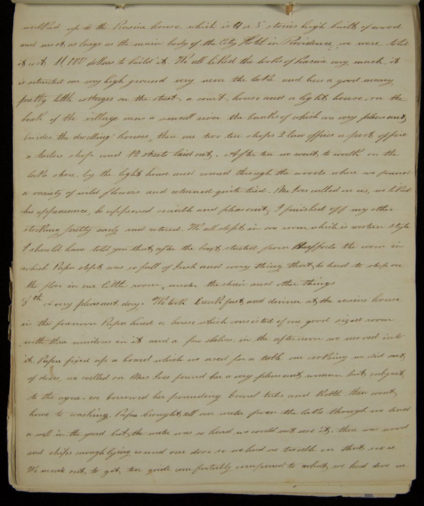
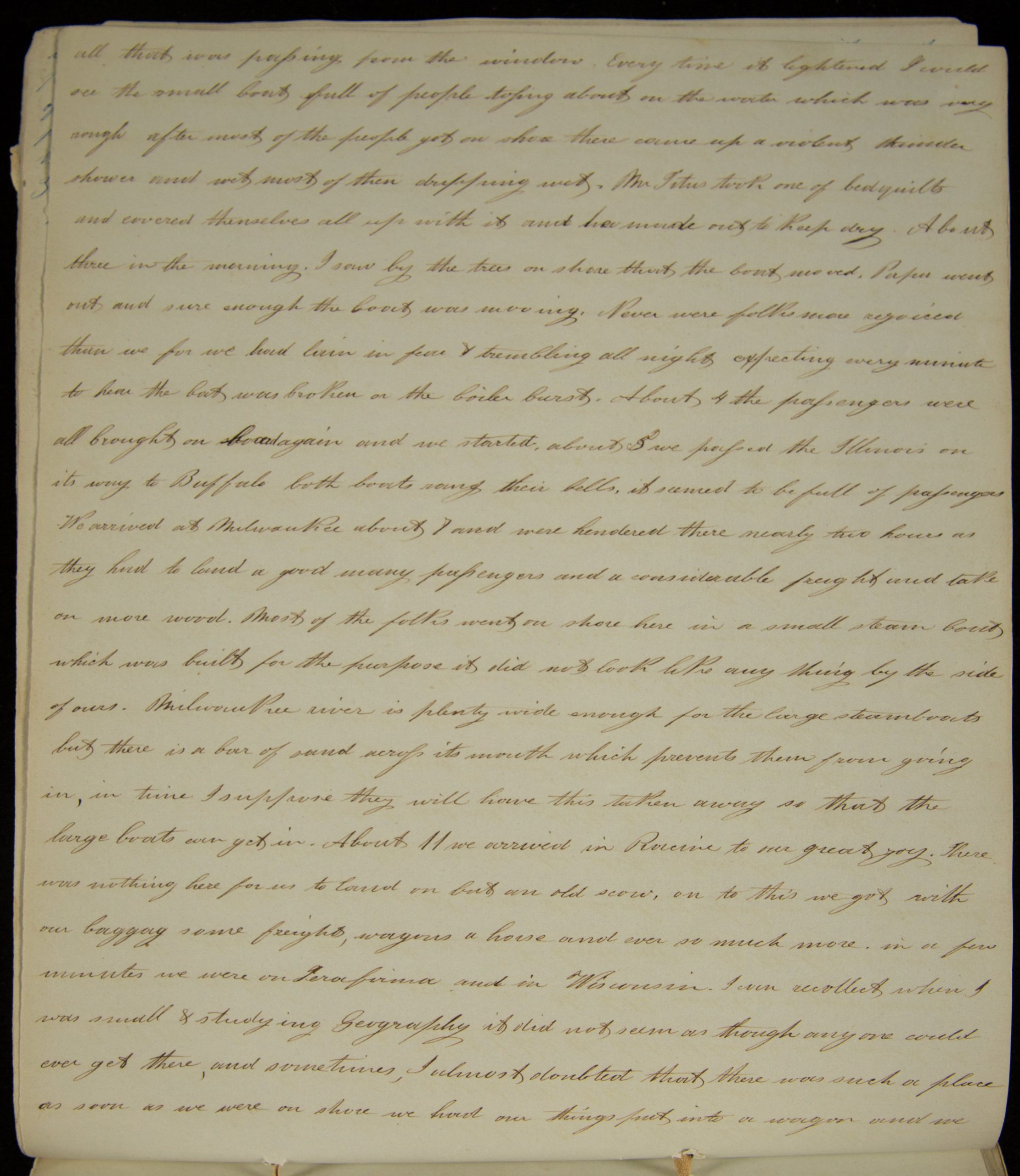
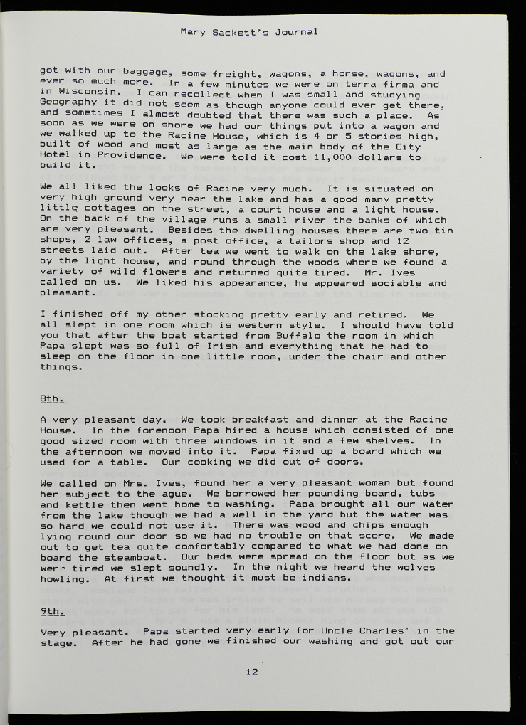
7th Pleasant in the morning. We landed and took on more wood. In the afternoon it clouded up and about sundown we had a violent storm of wind and rain accompanied with sharp lightning and heavy thunder in the evening Miss Smith I were sitting by the smoke pipe which was nearly opposite our room when on a suden the whole machinery stopped, we were very much frightened, but soon learned that the boat was aground on a bar of sand about 10 miles from Milwaukee. it was so foggy that we could not tell where we were at first. They tried to get the boat off first by moving the freight to one end of the boat then by making the passengers all go on one side of the boat and all men together to the other, but finding this would not do the commenced carrying the deck passengers on shore, Papa told us to go onto our births and lay still till he came back, but we said if he went on shore we would go too, so we all went into our little room, Papa sat down behind the door and we laid down in our berths, As mine was an upper birth I could see [page 14] walked up to the Racine house, which is 4 or 5 stores high built of wood and most as large as the main body of the City Hotel in Providence we were told it cost 11,000 dollars to build it. We all liked the look of Racine very much, it is situated on very high ground very near the lake and has a good many pretty little cottages on the street a court house and a light house, on the back of the village runs a small river the banks of which are very pleasant besides the dwelling houses, there are too ten shops 2 law offices a post office a tailors shop and 12 streets laid out. After tea we went to walk on the lake shore, by the light house and round through the woods where we found a variety of wild flowers and returned quite tired. Mr Ives called on use, we liked his appearance, he appeared sociable and pleasant. I finished off my other stocking pretty early and retired. We all slept in one room which is western style I should have told you that after the boat started from Buffalo the room in which Papa slept was so full of Irish and ever thing that he had to sleep on the floor in our little room, under the chair and other things[.]
8th A very pleasant day. We took breakfast and dinner at the racine house in the forenoon Papa hired a house which consisted of one good sized room with three windows in its and a few shelves. in the afternoon we moved into it. Papa fixed up a board which we used for a table our cooking we did out of doors, we called on Mrs Ives found her a very pleasant woman but subject to the ague. we borrowed her pounding board tubs and kettle then went home to washing. Papa brought all our water from the lake though we had a well in the ground but the water was so hard we could not use it. there was wood and chips enough lying round our door so we had no trouble on that sense…
But US westward expansion into the Ohio River and Mississippi River Valleys created tensions with the Native people upon whose lands white settlers encroached. In the early nineteenth century, the US government pressured Natives living east of the Mississippi River to cede their land in treaties and move west of the Mississippi River. In its dealings with Native Americans, the US government often exploited the disagreements between factions within Indigenous communities to buy Native lands in contentious treaties. Indeed, while certain factions refused to leave their homelands and sign treaties, others viewed resistance to the US settler expansion as futile and agreed to sign treaties and move farther west. The Thakawaki and Meskwaki (Sac and Fox), for instance, divided between those who refused to leave their homeland in southern Wisconsin and northern Illinois and those who relocated to Iowa.
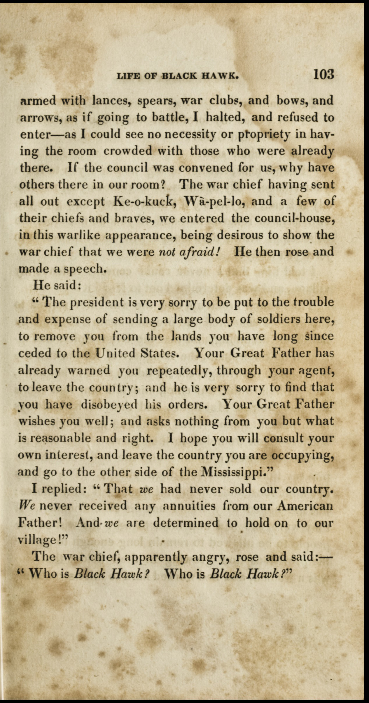
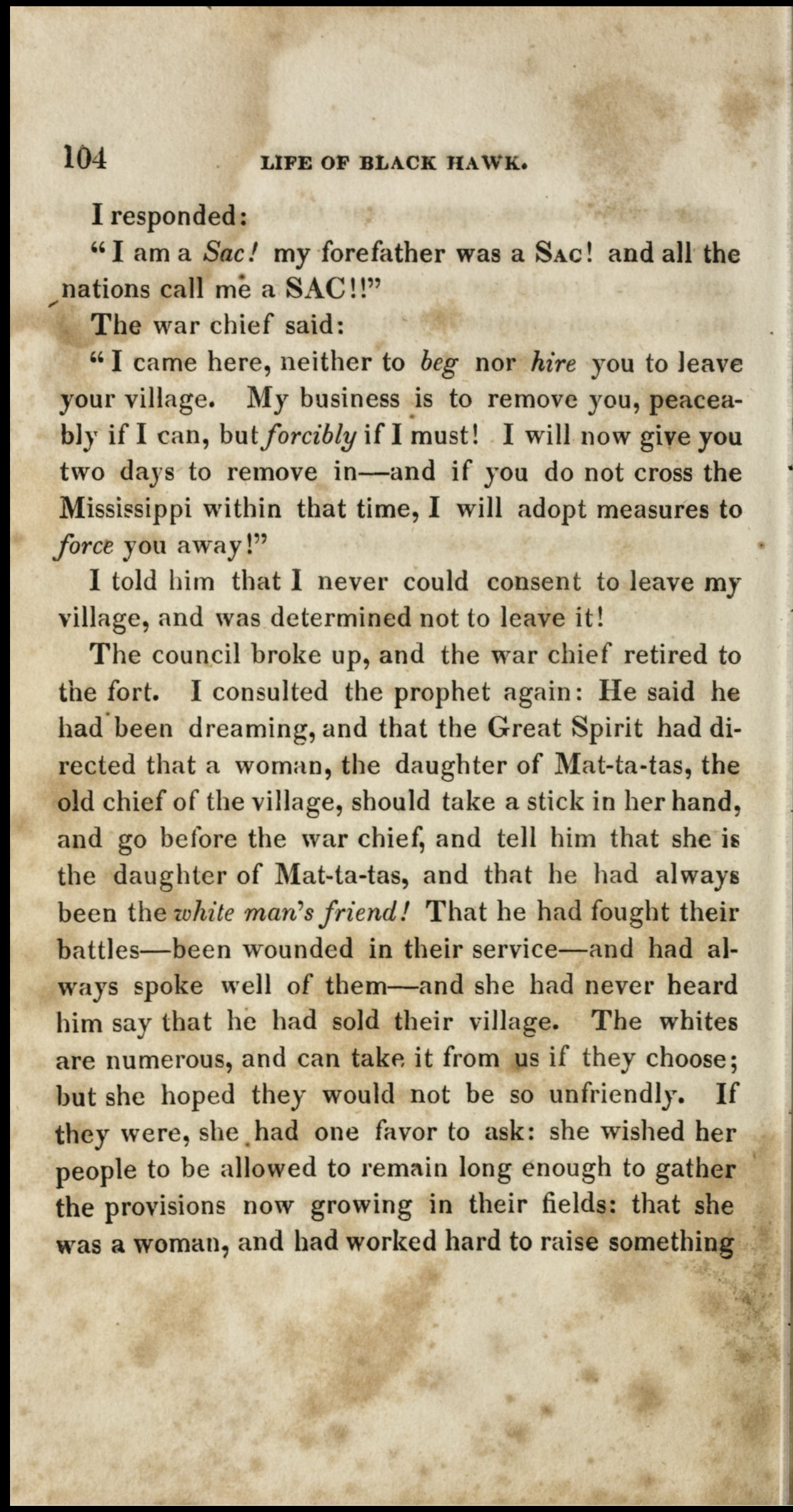
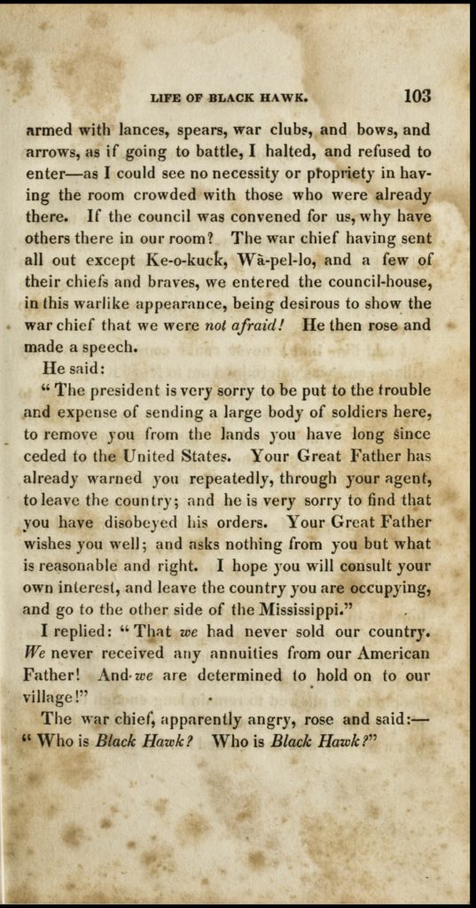
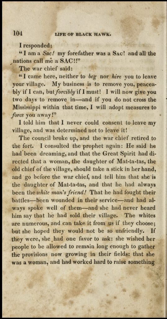
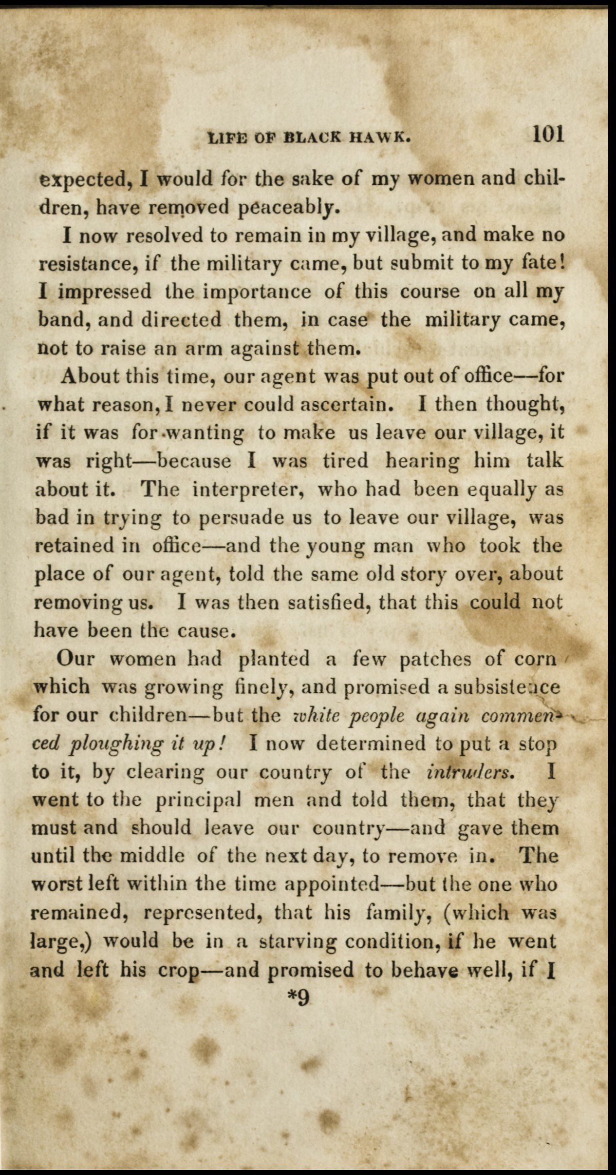
Tensions between white settlers and Natives sometimes erupted into warfare. Led by war leader Makataimeshekiàkiàk (Black Hawk), a group of 600 Sac warriors with their wives and children returned across the Mississippi River to plant corn in their Illinois homeland after wintering in Iowa. This resulted in the so-called Black Hawk War between the Illinois militia and US army and the Sac in the summer of 1832. The Sac evaded US forces for weeks but were caught and defeated at the Battle of Bad Axe, in which a US troop massacred 150 to 300 men, women, and children trying to escape across the Mississippi at gunpoint. Captured and imprisoned, Makataimeshekiàkiàk related his understanding of the conflict in his autobiography. For the US government, the so-called Sac “aggression” served as a pretext to accelerate the expulsion of most Natives from the upper Northwest Territory in the 1830s and 1840s.
Black Hawk, Life of Ma-ka-tai-me-she-kai-kiak or Black Hawk, title page (1833)
Black Hawk, Life of Ma-ka-tai-me-she-kai-kiak or Black Hawk, 101 (1833)
Black Hawk, Life of Ma-ka-tai-me-she-kai-kiak or Black Hawk, 102 (1833)
Black Hawk, Life of Ma-ka-tai-me-she-kai-kiak or Black Hawk, 103 (1833)
Black Hawk, Life of Ma-ka-tai-me-she-kai-kiak or Black Hawk, 104 (1833)
Questions to Consider:
Observe Vance’s map of the Erie Canal. Why did the construction of the canal facilitate and accelerate the westward transportation of people and merchandise from the Atlantic seaboard to the Great Lakes, as compared to previous travel methods such as rivers and lakes? What technological innovations and work were necessary to build the canal? What items on the map indicate the Haudenosaunee (Oneida, Cayuga, Onondaga, Seneca) history and presence in the eastern Great Lakes?
Using the passage from Mary Sackett’s Journal, trace the Sacketts’ westward journey from New York (route, modes of transportation, length, people they encountered). How do the family’s travel experiences compare to those of today?
What was Mary Sackett’s preconception of Wisconsin? Do you find it surprising? Why or why not? (See page 12.)
Read the passage from Black Hawk’s Autobiography. Compare and contrast General Gaines’s and white settlers’ views of Illinois and Wisconsin with Black Hawk’s view of the same land. How do they differ? How does Black Hawk describe white settlers, and why? How does his narrative compare to your previous understanding of Native life and white-Native encounters?
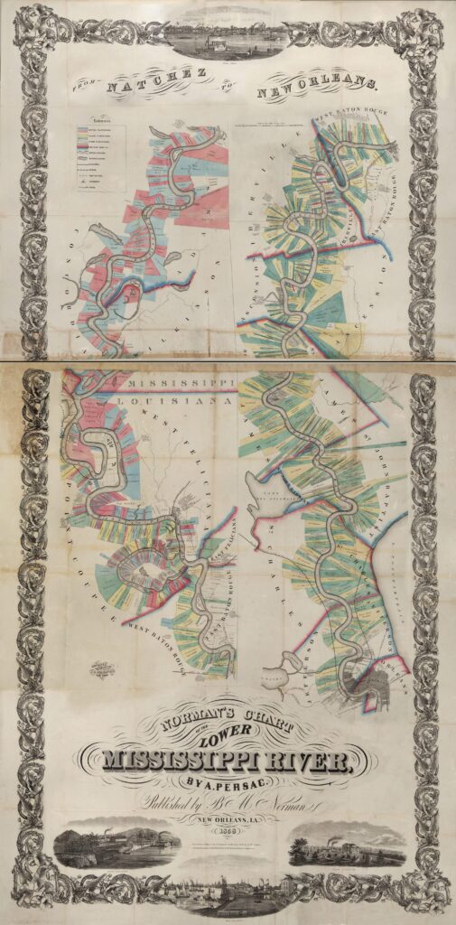
Traveling Up and Down the Mississippi River: New Orleans as a Port of Slavery, 1803-1860
In the South, westward expansion in the early nineteenth century led to the rise of the “Cotton Kingdom,” a region that relied on enslaved labor to grow cotton. Producing cotton used to be a long and laborious task. But in 1793, Eli Whitney’s invention of the cotton gin, a machine that quickly separated the seed from the cotton, revolutionized production. To turn southern states like Georgia, Alabama, Mississippi, and Louisiana into cotton-producing regions, white settlers and the US government expelled Cherokee, Creek, and other Indigenous communities from their homelands. The most infamous forced displacement was that of the Cherokee on the Trail of Tears from Georgia and Tennessee to Oklahoma in 1838.
Between 1800 and 1860, planters also imported about one million enslaved people from the “Old South” (Virginia, Maryland, North Carolina, and South Carolina) to the Cotton Kingdom. In the late eighteenth and early nineteenth centuries, many white Americans had expected Black slavery to die out due to land exhaustion in the Old South and the 1808 ban of the international slave trade. But the development of the Cotton Kingdom revitalized slavery, causing devastating family separations and numerous dehumanizing experiences for enslaved people.
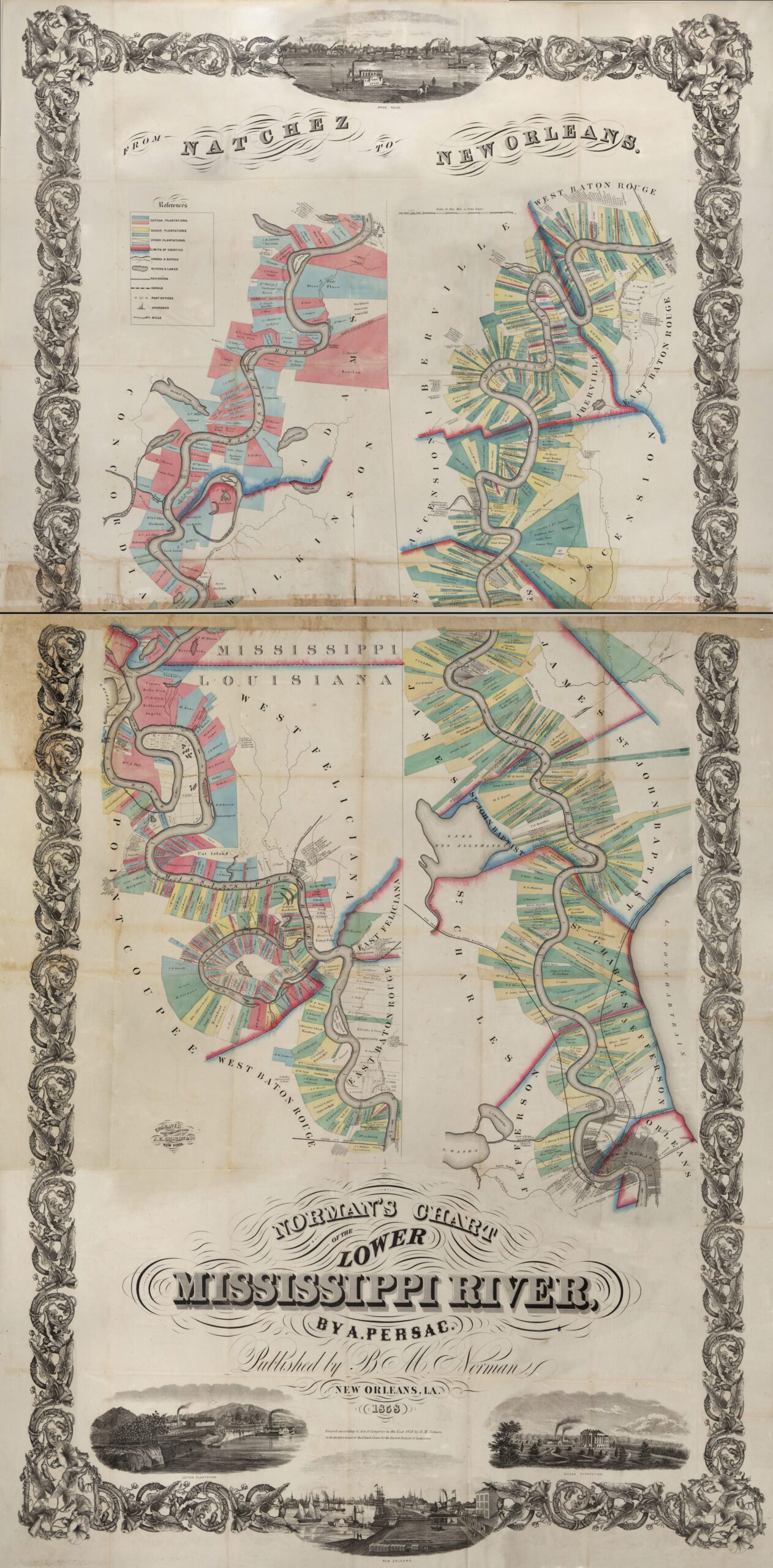
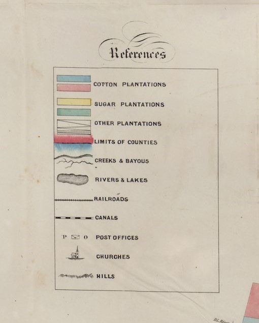
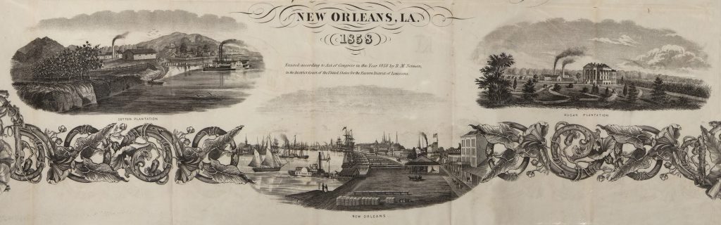
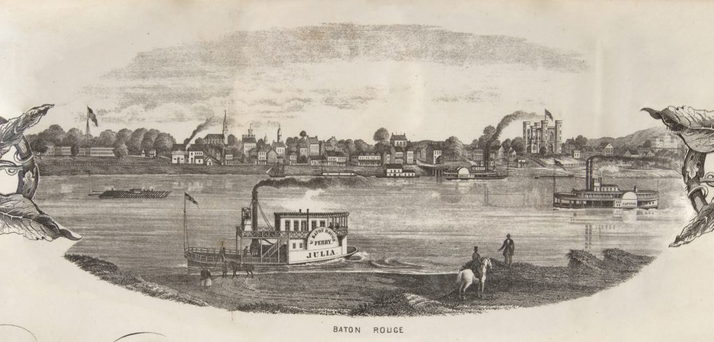
Marie Adrien Persac, Norman’s Chart of the Lower Mississippi, “References” (1858)
Marie Adrien Persac, Norman’s Chart of the Lower Mississippi, detail “New Orleans” (1858)
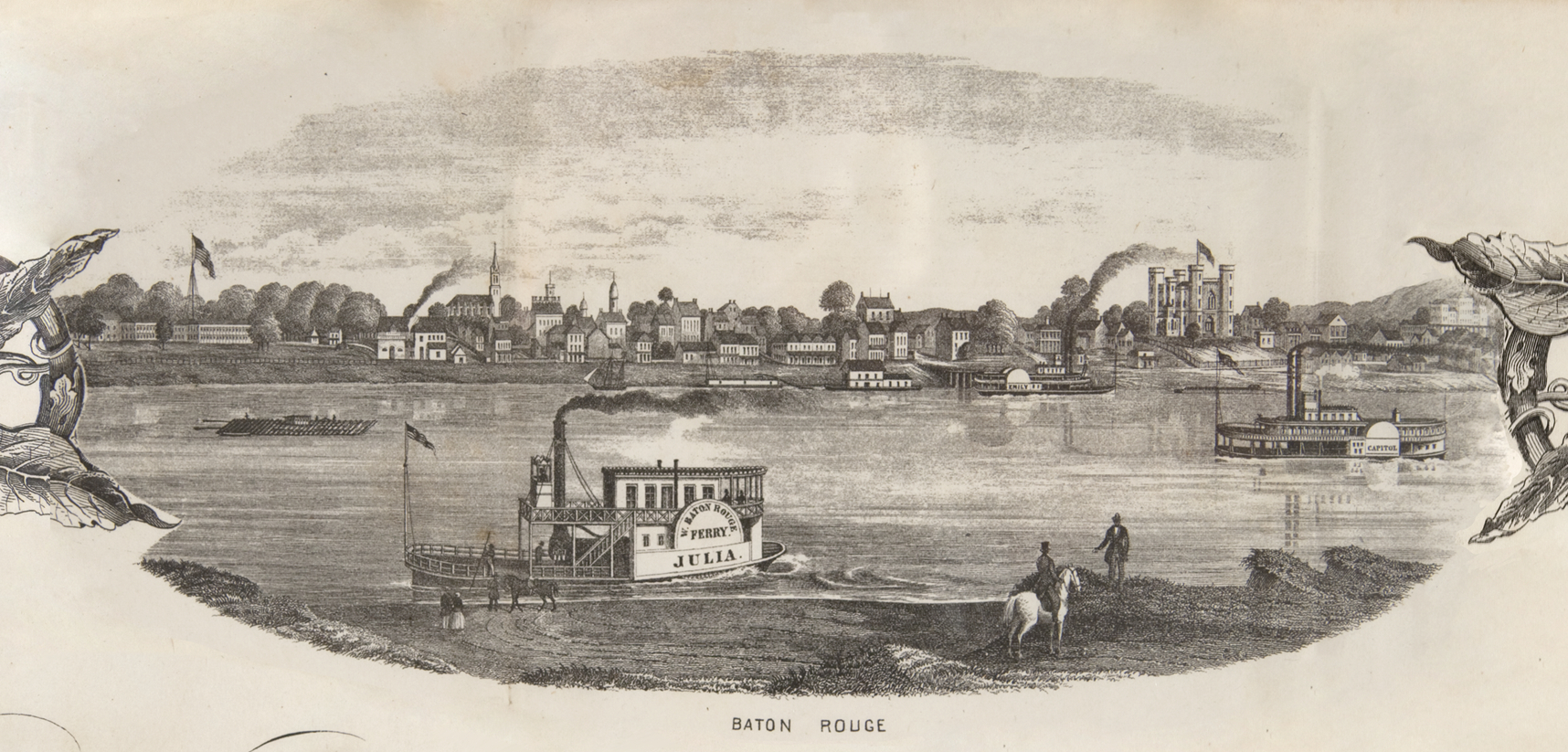
Marie Adrien Persac, Norman’s Chart of the Lower Mississippi, detail “Baton Rouge” (1858)
Between 1830 and 1860, 70,000 to 100,000 enslaved people fled the Cotton Kingdom and other parts of the South to freedom, north of the Ohio River, in Canada, and in Mexico.[1] By the early 1840s, this flight from enslavement became known as the Underground Railroad, a metaphor inspired by the growth of the railroad. While a system of safe houses and “conductors” (white and Black people assisting freedom seekers) existed, the Underground Railroad was primarily made of the individual choices, paths, and experiences of enslaved individuals willing to risk death to escape slavery.
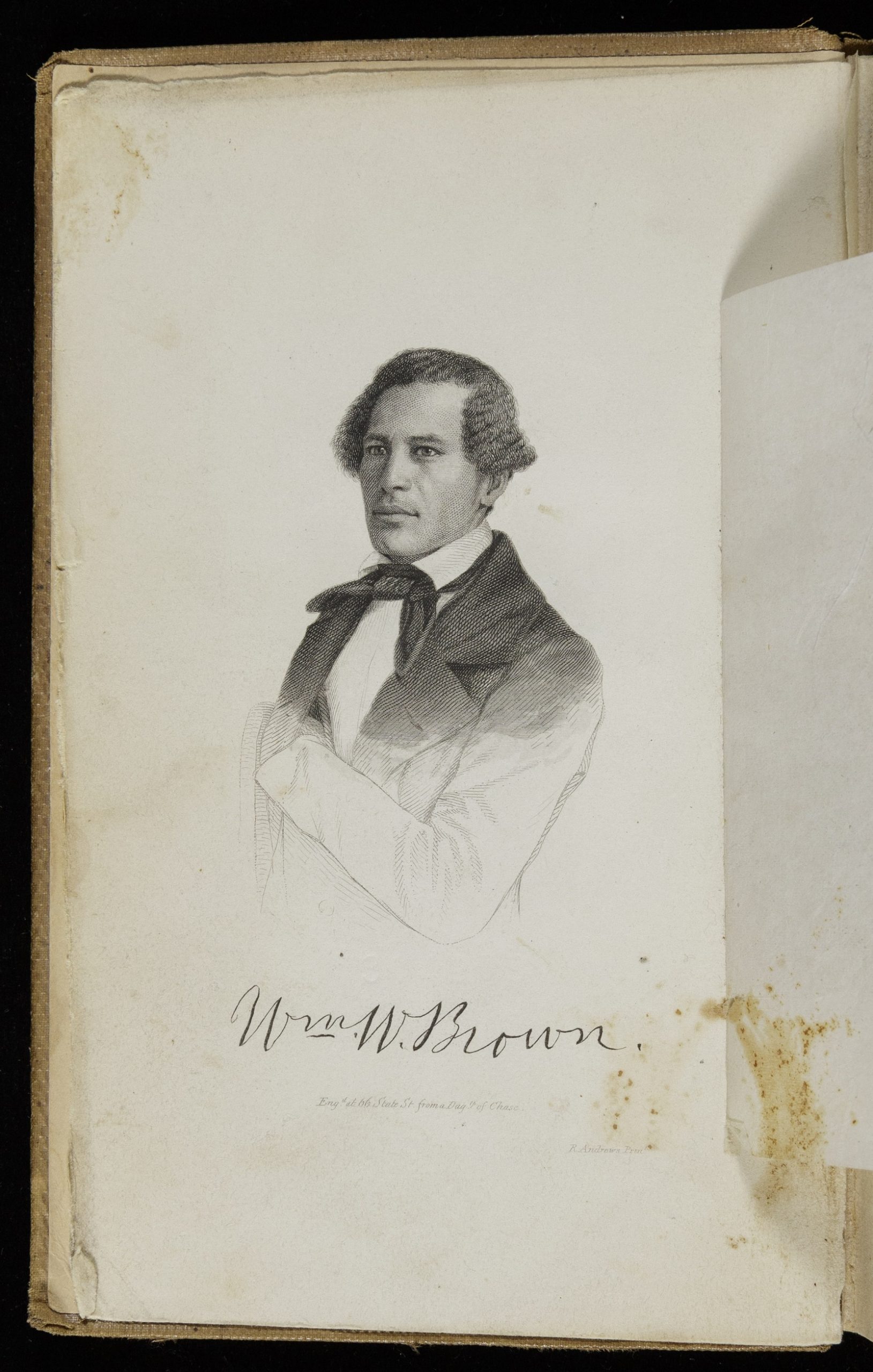
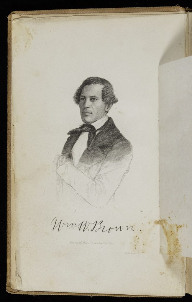
William Wells Brown was one such freedom seeker. Born into slavery in Kentucky around 1814, Brown spent most of his enslaved life in St. Louis, Missouri. There, his enslaver hired him out to a slave trader, a position that entailed regular travels on steamships along the Mississippi River to assemble slave caravans for sale in Natchez and New Orleans. After failing twice to escape, Brown successfully self-emancipated in 1834, at the age of nineteen, while accompanying his new enslaver on a trip up the Mississippi and Ohio Rivers. He later narrated his difficult journey to freedom in his 1847 autobiography. Once a free man, Brown became a conductor of the Underground Railroad in Cleveland, working on steamboats and ferrying dozens of freedom seekers across Lake Erie to Canada.
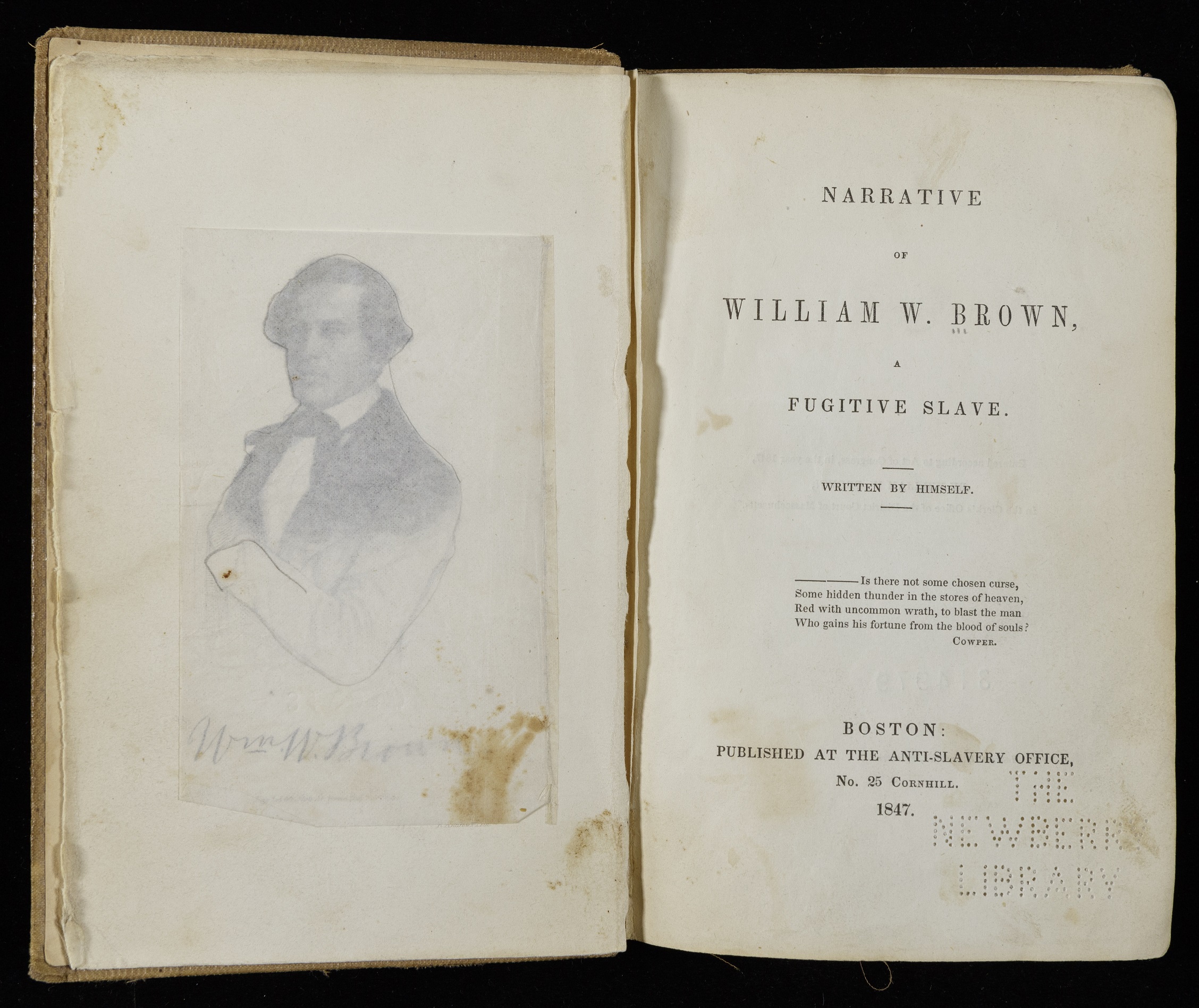
William Wells Brown, Narrative of William W. Brown, A Fugitive Slave, title page (1847)
William Wells Brown, Narrative of William W. Brown, A Fugitive Slave, frontispiece (1847)
William Wells Brown, Narrative of William W. Brown, A Fugitive Slave, 90 (1847)
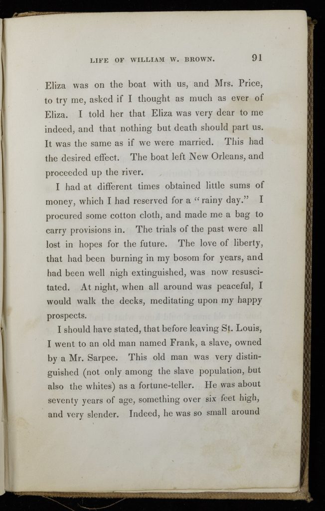
William Wells Brown, Narrative of William W. Brown, A Fugitive Slave, 91 (1847)
William Wells Brown, Narrative of William W. Brown, A Fugitive Slave, 92 (1847)
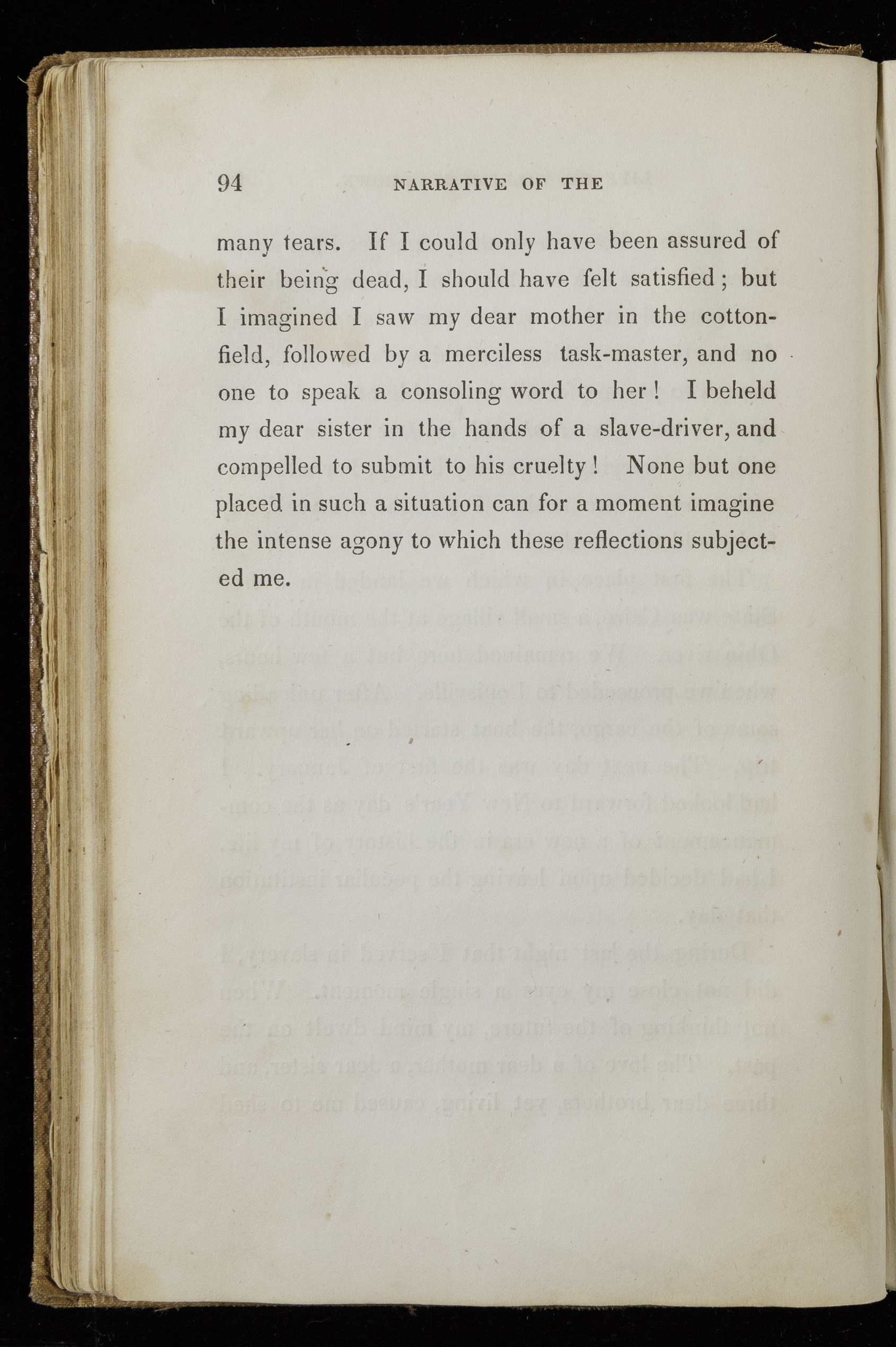
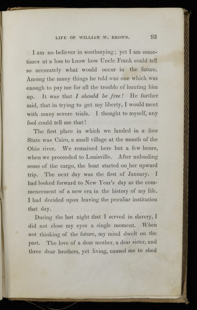
William Wells Brown, Narrative of William W. Brown, A Fugitive Slave, 93 (1847)
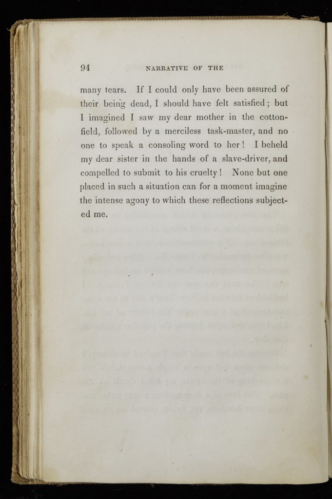
William Wells Brown, Narrative of William W. Brown, A Fugitive Slave, 94 (1847)
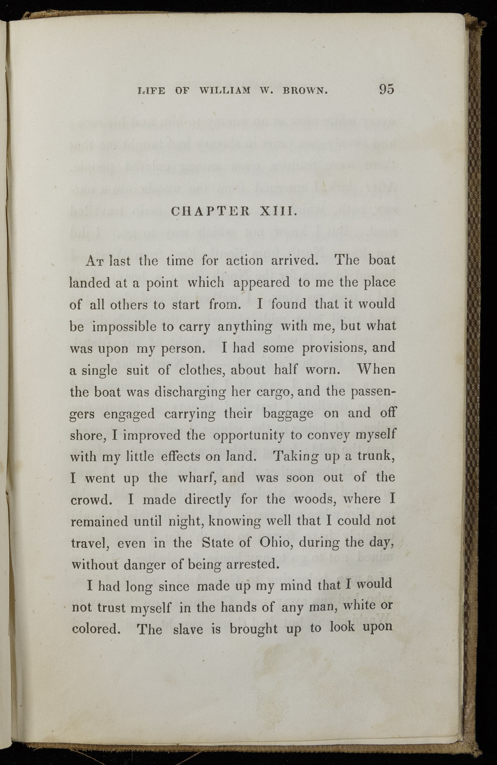
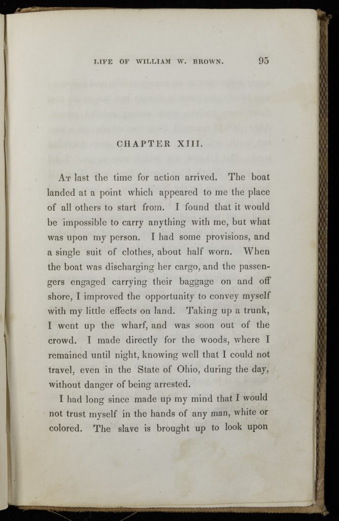
William Wells Brown, Narrative of William W. Brown, A Fugitive Slave, 95 (1847)
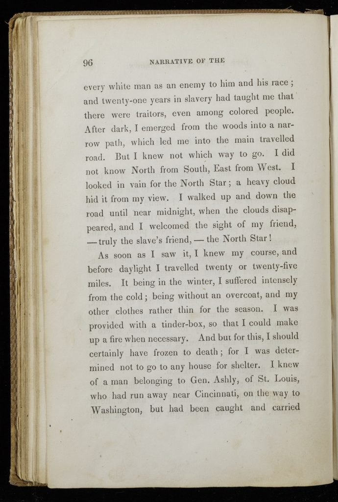
William Wells Brown, Narrative of William W. Brown, A Fugitive Slave, 96 (1847)
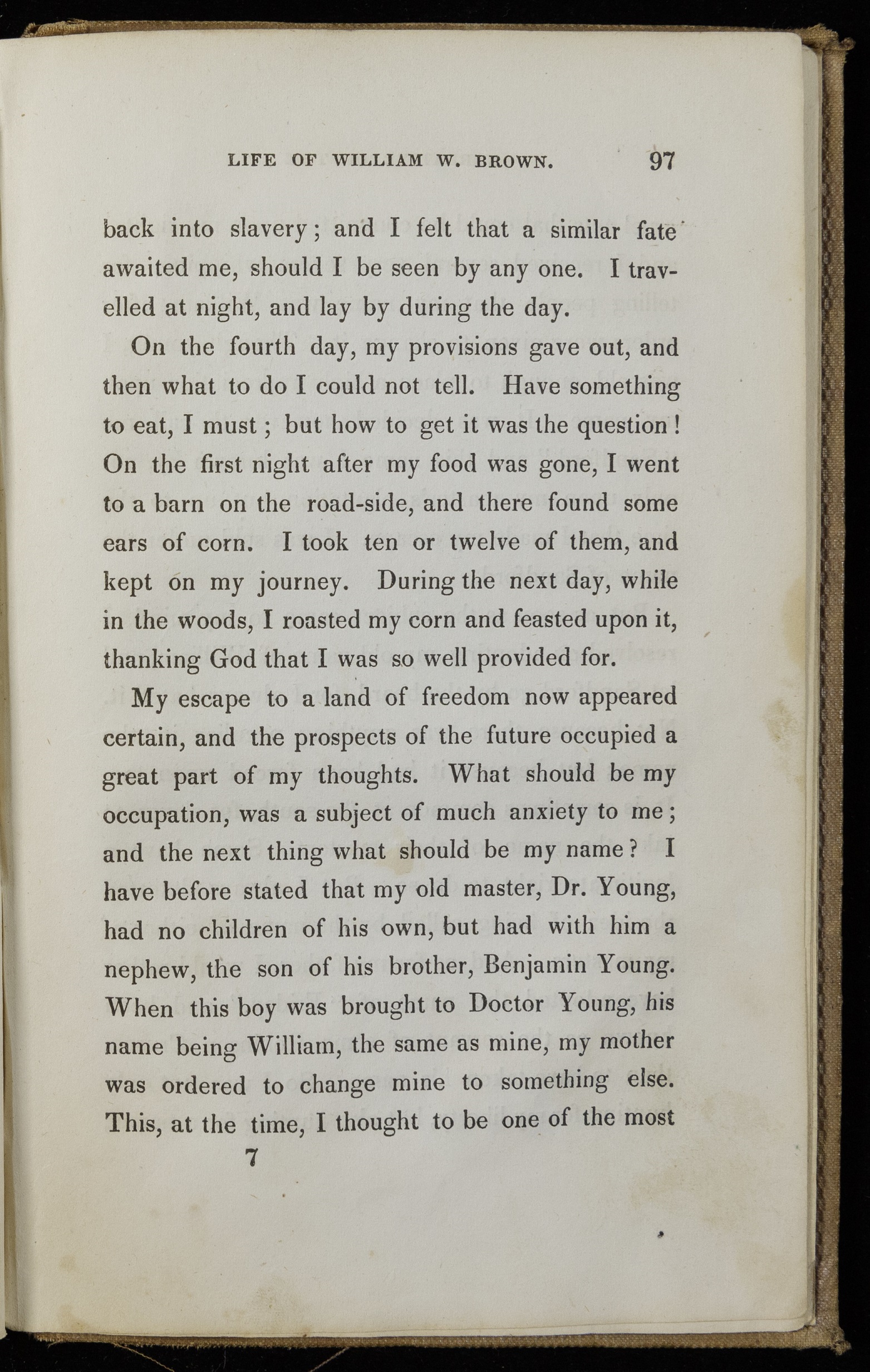
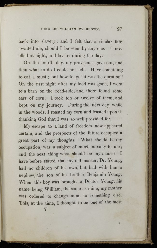
William Wells Brown, Narrative of William W. Brown, A Fugitive Slave, 97 (1847)
Questions to Consider:
Analyze the 1858 map of the lower Mississippi River. What were the main crops produced on the region’s plantations? How were the plantations laid out, and how did this organization facilitate trade?
What information is included in this map? For an illustrated map of plantations, why do you think the mapmaker did not represent enslaved people? Given the information included in and left out from the map, who might have been the map’s users and owners? What can you infer from this map about what and who its maker and users valued (or did not value)?
What are the challenges that William Wells Brown faced as he contemplated escaping slavery and during his escape? How were they specific to the experience of a Black enslaved person?
[1] Fergus M. Bordewich, Bound for Canaan: The Underground Railroad and the War for the Soul of America (New York: HarperCollins, 2005), 436.
Transcontinental Railroads and Native Peoples in the Great Plains, 1860s-1890s
At the end of the Civil War in 1865, the map of the continental United States looked similar to the one we know today. But in reality, Native Americans remained in control of the trans-Mississippi West and the frontier of continuous white settlement stopped at the Mississippi River. Later in the nineteenth century, the settlement of the West and its integration with the US economy dispossessed Indigenous people of their lands on a massive scale. The newly constructed transcontinental railroads played a major part in this transformation.
The transcontinental railroads were, in effect, products of the Civil War and the increasingly powerful federal government. During the war, Congress passed a series of acts providing for the construction of transcontinental railroads on the grounds of military necessity. The federal government subsidized the construction of these costly new lines, which stretched between cities on the Missouri River and the Pacific Coast, granting railroad companies a section of land (and the coal and iron it contained) for each mile of tracks built. While in US mythology the West remains the land of individualism, its development and white settlement owed much to the federal government and to large railroad corporations. Indeed, the construction of transcontinental railroads often preceded white settlement. Railroads aggressively promoted the trans-Mississippi West to potential settlers on the East Coast and abroad to profit by selling the large tracts of land granted to them by the federal government and, in the process, by gaining new customers. In Minnesota, North Dakota, South Dakota, Nebraska, and Kansas, the population rose from 300,000 in 1860 to 5 million in 1900.[2] Most settlers—German and Scandinavian immigrants, white East-Coast transplants, and Black people—worked there as farmers, transforming Indian Country into a wheat and corn belt, producing grain for national and international markets on land that had recently been dispossessed from Native nations.
The advent of the transcontinental railroads and the influx of settlers threatened Native Americans and their way of life. As settlers encroached on Indigenous lands, warfare between the US Army and Plains nations started in the 1850s. To weaken Native power, the US Army intentionally destroyed the basis of the Indigenous economy, especially the buffalo. Native nations resisted as the United States sought to confine them to reservations that occupied only a fraction of their homelands. For example, the Lakota and Cheyenne, led by Tȟatȟáŋka Íyotake (Sitting Bull) and Tȟašúŋke Witkó (Crazy Horse), fought for their lands and the sacred Black Hills in Dakota Territory. They famously defeated General Custer and his men at the Little Bighorn in the summer of 1876. But such victories only delayed the westward expansion of settlers, soldiers, and railroads.
Questions to Consider:
Who produced the Guide to the Lands of the Northern Pacific Railroad in Minnesota, and who was its intended audience?
What sections of the Northern Pacific Railroad were completed in 1872, and what remained to be built? What traces of a non-Indigenous presence can you identify beyond Minnesota? Based on your previous answers, what can you infer about the white settlement of the trans-Mississippi West in 1872?
What does this map suggest about US territorial ambitions and the way the United States projected its power over the trans-Mississippi West?
[2] Eric Foner, Give Me Liberty! An American History, Seagull 4th edition (New York: W. W. Norton, 2014), 604.
Automobile Travel in California and Lake Superior: Tourists, “Okies,” and Native Encounters in the 1930s
The popularization of automobiles together with the building of the first national highways in the 1920s encouraged a new form of mobility in the United States. Until World War I, automobiles were a luxury good for urban elites. Automobiles became more affordable after Henry Ford perfected the moving assembly line of manufacturing, and the numbers of cars registered in the United States rose from 500,000 in 1910 to 23 million in 1930.[3] With the automobile’s rapid growth, advocates of improved roads, including the National Highways Association, formed the Good Roads movement. One of their main achievements was the passing of the Federal Highway Act in 1921, which called for the construction of a system of interconnected interstate highways.
The most iconic route in the national highway system was US 66, which reached across more than 2,400 miles and eight states (Illinois, Missouri, Kansas, Oklahoma, Texas, New Mexico, Arizona, and California) between Chicago and Los Angeles. Advertisements, novels, and songs like Bobby Troup’s “Get Your Kicks on Route 66,” made Route 66 famous throughout the United States and beyond.
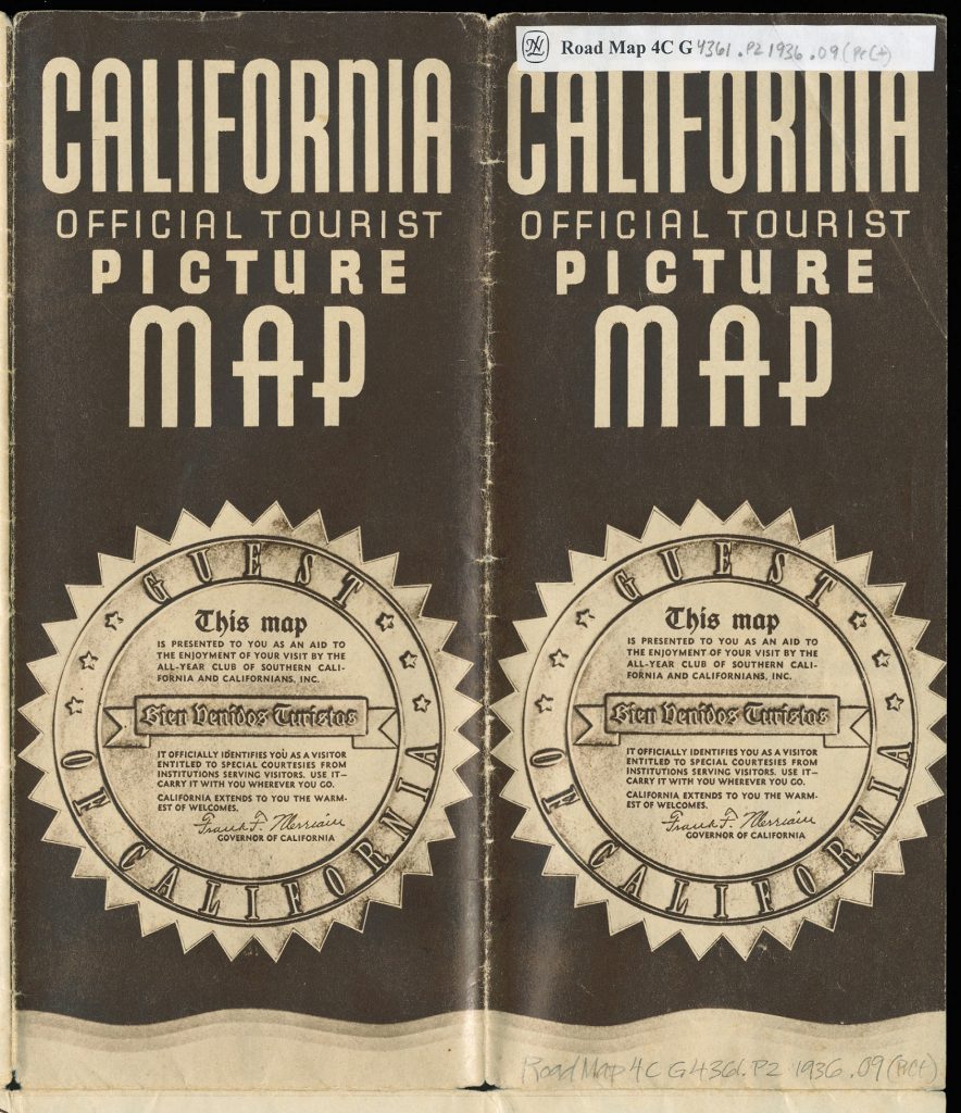
Charles Owens, California Official Tourist Picture Map, cover (1936)
Charles Owens, California Official Tourist Picture Map, full interior (1936)
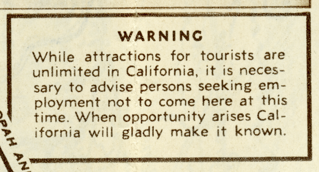
Charles Owens, California Official Tourist Picture Map, detail of warning (1936)
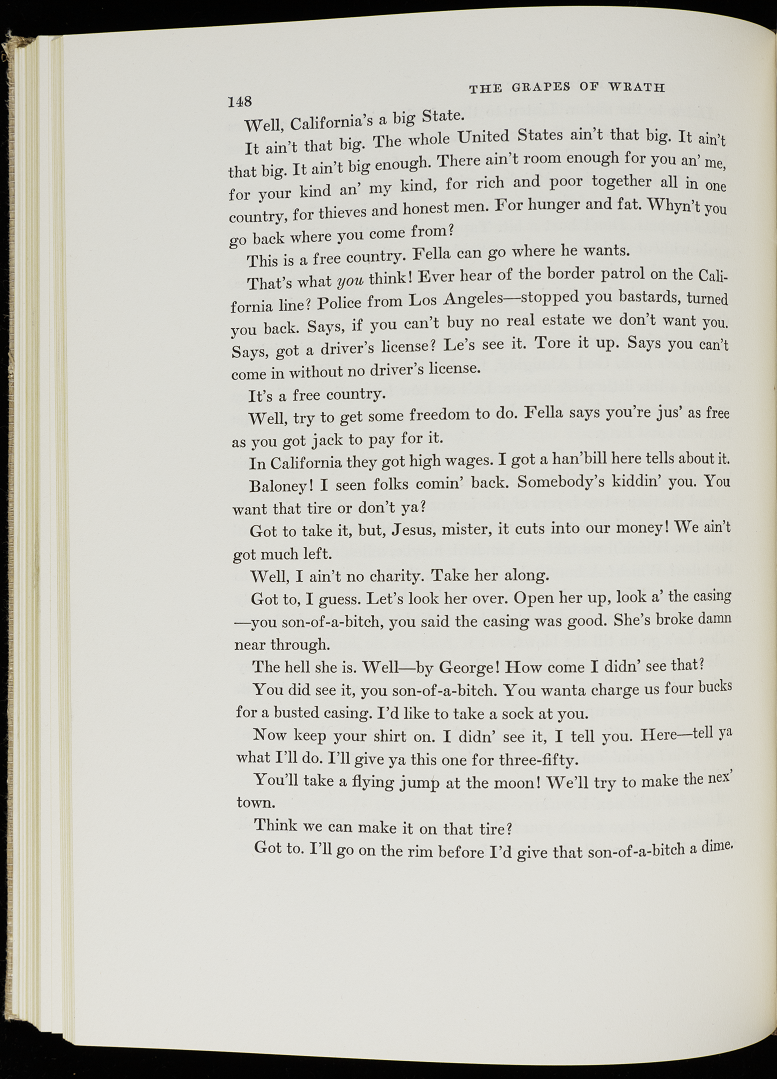
In the 1930s, travelers headed to California along Route 66 for various reasons. As John Steinbeck dramatized in his best-selling novel The Grapes of Wrath (1939), desperate farming families fleeing the Dust Bowl were lured by the prospect of work and better living conditions in California. The Dust Bowl (1930-1940) was a decade of drought in the southern Great Plains (Texas, Oklahoma, Kansas, Nebraska, Colorado, and New Mexico). The drought caused overexploited, eroding lands to blow away in dust clouds that darkened the sky for days. Left without their livelihood, 250,000 migrants, nicknamed “Okies,” sold the things they could not load in their cars and sought refuge in California. The Grapes of Wrath is a work of fiction following the adventures of the imaginary Joad family of Oklahoma, but was inspired by Steinbeck’s direct observation and interviews of Dust Bowl migrants in California between 1936 and 1938.
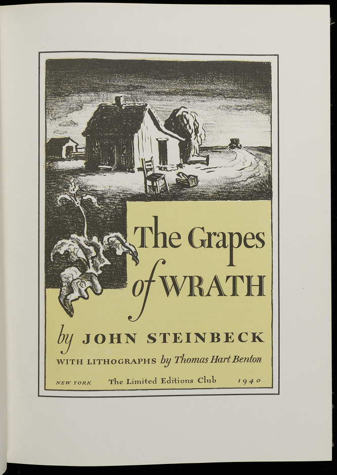
John Steinbeck, The Grapes of Wrath, title page (1940)
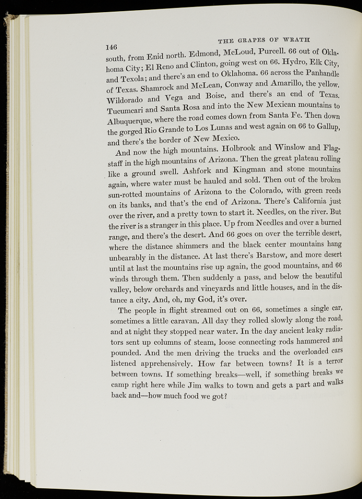
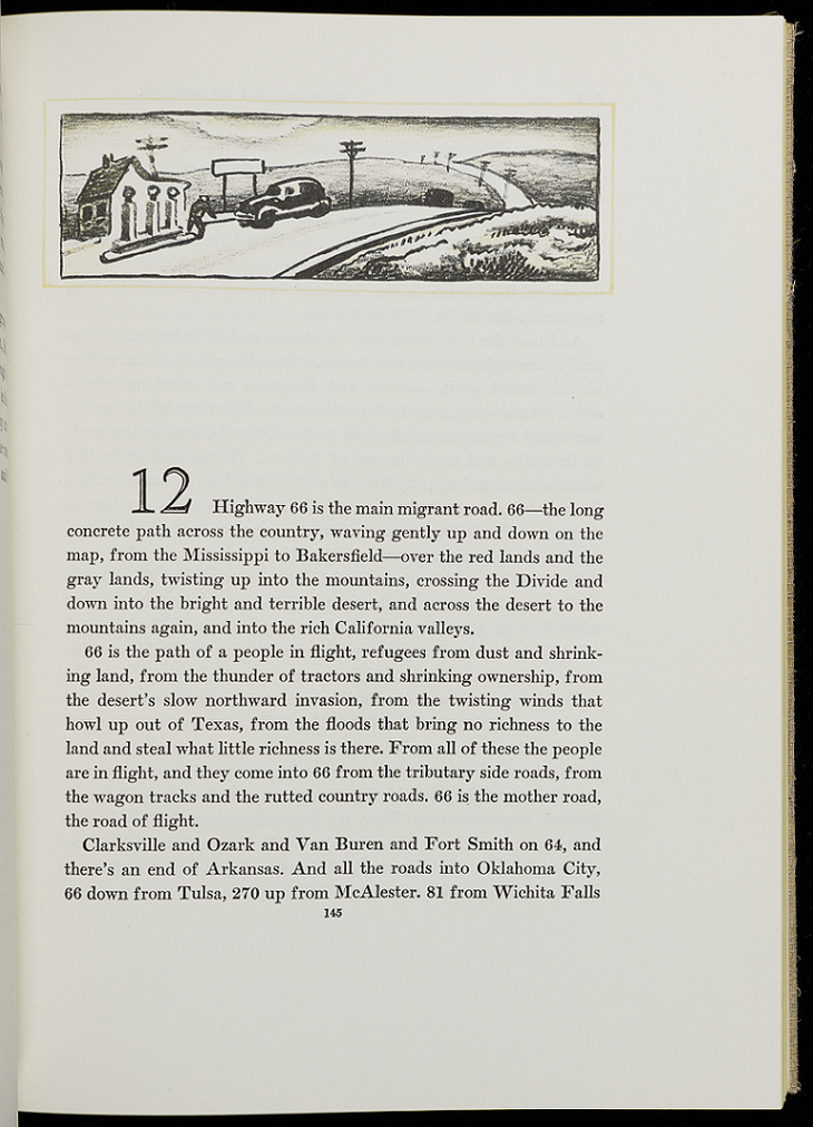
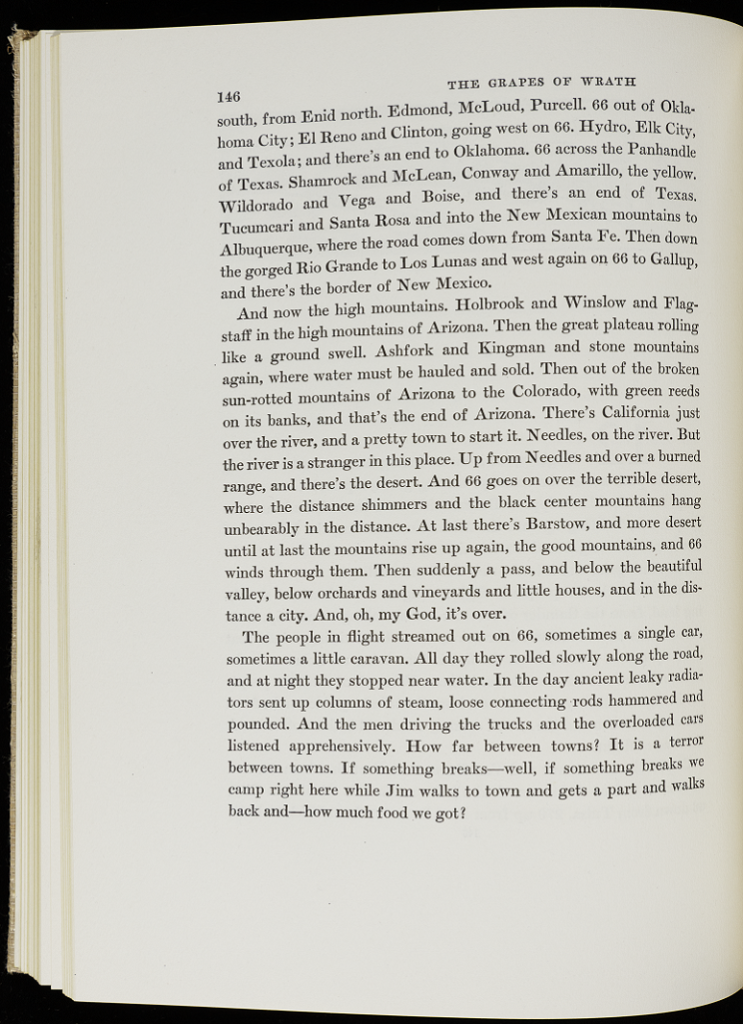
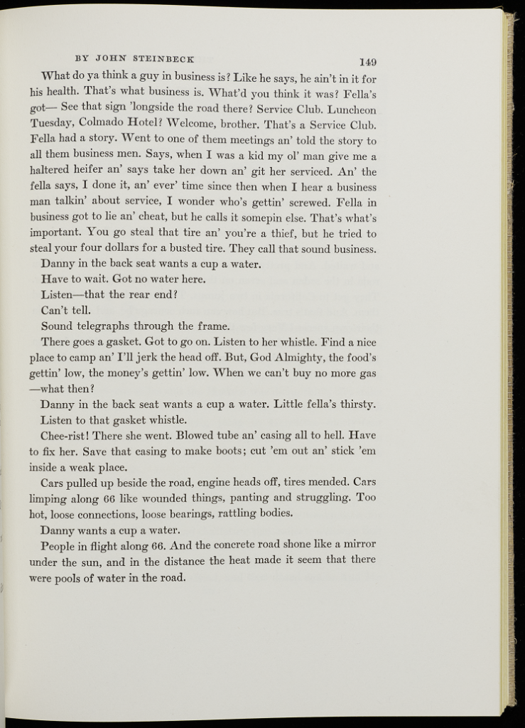
John Steinbeck, The Grapes of Wrath, 145 (1940)
John Steinbeck, The Grapes of Wrath, 146 (1940)
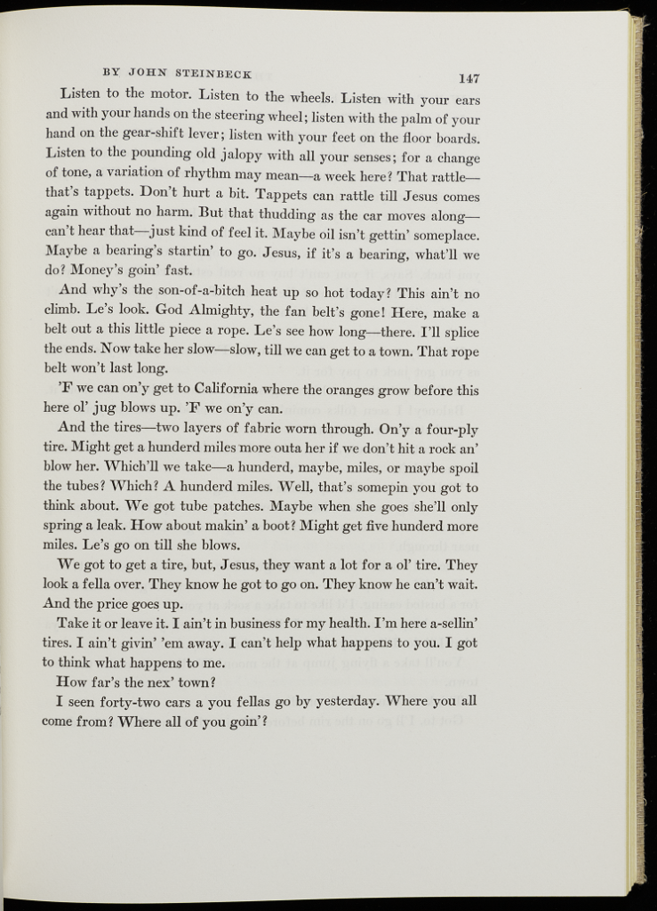
John Steinbeck, The Grapes of Wrath, 147 (1940)
John Steinbeck, The Grapes of Wrath, 148 (1940)
John Steinbeck, The Grapes of Wrath, 149 (1940)
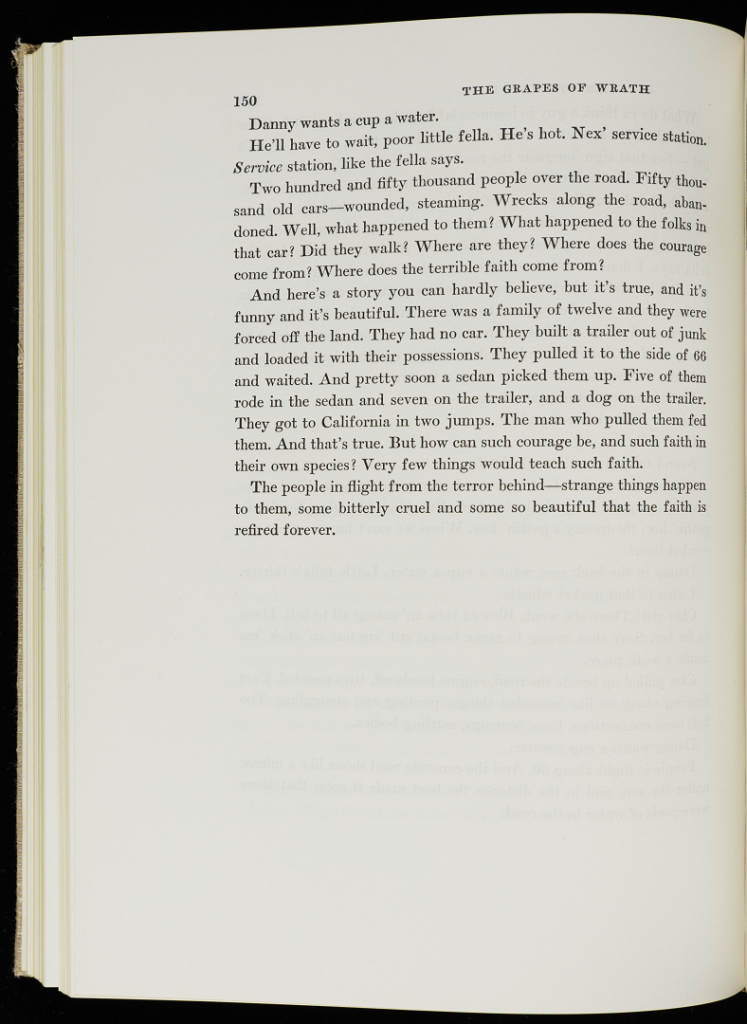
John Steinbeck, The Grapes of Wrath, 150 (1940)
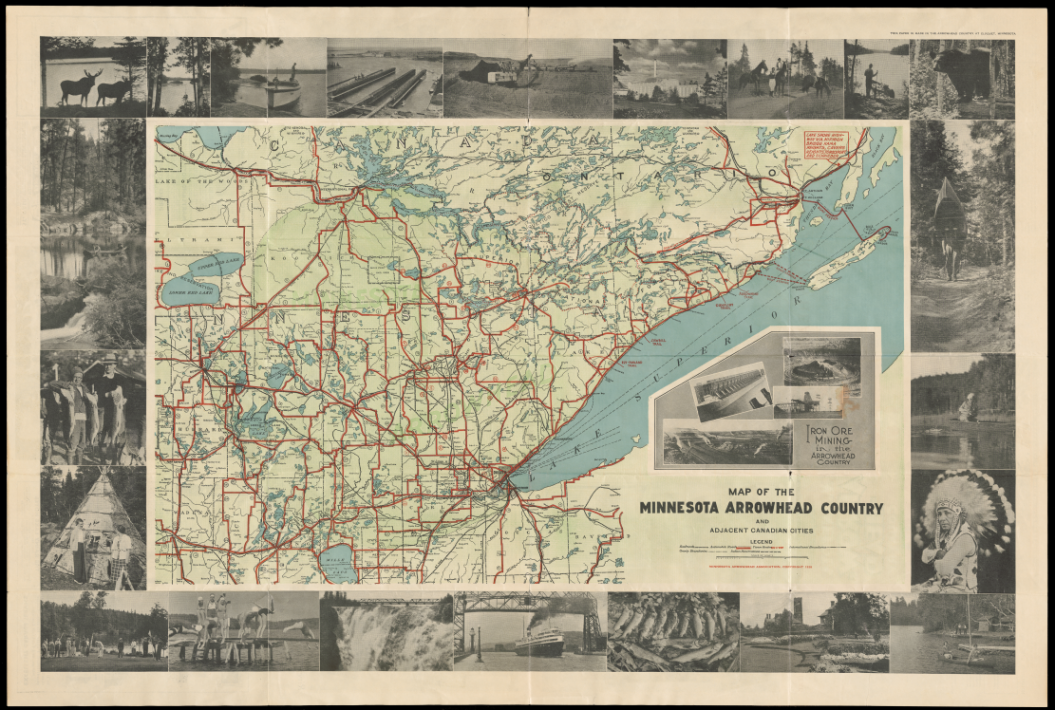
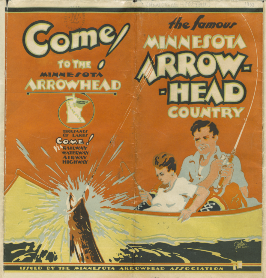
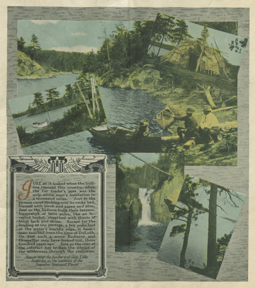
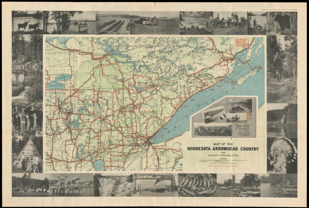
The advent of the automobile also shaped another kind of travel: tourism. After 1880, advocates increasingly presented tourism as a ritual of American citizenship, encouraging Americans, mostly middle- and upper-class white Americans, to see the nation firsthand and follow in the footsteps of American “pioneers” and history—or rather of selected events and narratives. The promotion of the Good Roads movement went hand-in-hand with the promotion of automobile tourism, especially transcontinental and out-of-state travel. By the 1930s, California (via Route 66) became a major tourist destination. Minnesota, with its 10,000 lakes and favorable summer climate, turned into one of the country’s premier summer vacation destinations in the early twentieth century. For an increasingly industrial and urban nation, the automobile presented an opportunity for city dwellers to get ‘back to nature’ in areas like the Minnesota lakes that they perceived as idyllic, pristine wilderness. But these territories had long been (and often continue to be) peopled, traveled, and transformed by Indigenous people.
Minnesota Arrowhead Association, Map of the Minnesota Arrowhead Country and Adjacent Canadian Cities, cover (1938)
Minnesota Arrowhead Association, Map of the Minnesota Arrowhead Country and Adjacent Canadian Cities, interior pages (1938)
Minnesota Arrowhead Association, Map of the Minnesota Arrowhead Country and Adjacent Canadian Cities (1938)
Questions to Consider:
Analyze the pictorial map of California and the map of the Minnesota Arrowhead. Who commissioned each map, when, and for what purposes? Who is the intended audience of each map? What evidence helps you determine the audience’s assumed class, race, and gender?
What are the main kinds of tourist attractions promoted on these two maps? What narratives of the United States, California, and Lake Superior do these tourist attractions promote? What and/or who are left out of the narrative, or stereotyped? How do the views of California and Upper Minnesota conveyed in these two maps compare to your own ideas or experiences of these areas?
How does Thomas Hart Benton, the illustrator of The Grapes of Wrath, convey the idea of Oklahoma as a place deserted by migrants fleeing the Dust Bowl?
Analyze the dialogue about California in the Grapes of Wrath (p. 147-148). How are California and its migration policy in the 1930s depicted in the dialogue? How does it compare to the message for migrants conveyed in Owen’s pictorial map of California?
How does Steinbeck’s description of travel along Route 66 relate to your own experience and/or ideas of Route 66?
[3] John Rae, The Road and the Car in American Life (Cambridge, MA: MIT Press, 1971), 50.
About the Author
Gabrielle Guillerm, PhD, is a historian of the United States and the West. She is the assistant curator of the Newberry exhibition, Crossings: Mapping American Journeys(February-June 2022).
Any views, findings, conclusions, or recommendations expressed in this program, do not necessarily represent those of the National Endowment for the Humanities.


![Black-and-white 16-point compass rose with "References" key below. Key identifies villages, seats of justice, post offices, town and county lines, mills and manufactoires [sic], roads, and canals and locks.](https://dcc.newberry.org/wp-content/uploads/2022/05/ord_chs_-coll_map_no_203a_001_Key.png)


![Page of printed text on aged, stained paper. Text reads, "would consent to let him remain until fall, in order to secure his crop. He spoke reasonably, and I consented. We now resumed some of our games and pastimes--having been assured by the prophet that we would not be removed. But in a little while it was ascertained that a great war chief, [Gen. Gaines,] with a large number of soldiers, was on his way to Rock river. I again called upon the prophet, who requested a little time to see into the matter. Early the next morning he came to me, and said he had been dreaming! 'That he saw nothing bad in this great war chief, [Gen. Gaines,] who was now near Rock river. That the object of his mission was to frighten us from our village, that the white people might get our land for nothing!' He assured us that this 'great war chief date not, and would not, hurt any of us. That the Americans were at peace with the British, and when they made peace, the British required, (which the Americans agreed to,) that they should never interrupt any nation of Indians that was at peace--and that all we had to do to retain our village, was to refuse any, and every offer that might be made by this war chief.' The war chief arrived, and convened a council at the agency Ke-o-kuck and Wà-pel-lo were sent for, and came with a number of their band. The council-house was opened, and they were all admitted. Myself and band were then sent for to attend the council. When we arrived at the door, singing a war song, and"](https://dcc.newberry.org/wp-content/uploads/2022/05/BlackHawk_102-537x1024.jpg)


![Dear Brother, I now commence the journal which I promised to keep for your reading. I shall not have anything to write I fear that will be very interesting to you. A journal, of such common events and from such a pen as mine will I fear merit but little of your attention, but if you will promise that no eyes but yours shall see this, I will do the best that I can hoping that wherein I fail your better judgement and kindness will allow you to correct me. I shall commence on the 18th of May 1841. After a painful parting with you and our friends we retired to the cabin which we found nearly full of Irish Dutch or English, who were preparing their supper, which they spread upon the cabin table and eat with much apparent enjoyment. We took tea with the Captain whom we found to be quite a jovial sort of a man. he told us that he was going to take his wife on board, as soon as he came to his farm which lay on the banks of the river, and give her a sail for her health, and she would be some company for us. We did not, however, reach the farm before night and were thus deprived of the lady's society. Her health not permitting her to venture out at so late an hour. The steamboat on which we sailed was called the Commerce and at that time had five boats in tow which were well laden and prevented our going fast. We retired at an early hour with severe headaches which after a night of sound sleep was entirely dispersed. 19th When we arose we found that we had proceeded but [[unknown]] toward Troy, You will remember that when we left N.Y. we [[unknown]] rain at least every other day. It being pleasant the day we started, of course expected rain today but were favored with pleasant weather](https://dcc.newberry.org/wp-content/uploads/2022/09/mms_038_box_01_fl_001_001_o2-scaled.jpg)
![though light clouds occasionally obscured the sun. We spent most of the day on deck, where we took our rocking chairs, and sat very comfortably, with our cloaks and bonnets on. Papa and Dick walked the deck most of the time, Mama knit and Caroline and myself sewed on our patchwork. We had some conversation with some of our fellow [[passengers?]], whom we found had arrived in N.Y. but, the day before they left there, and like ourselves were bound for the west. The scenery along the river at this time of the year was indeed beautiful. The many farms, landings or villages formed as many a handsome scene for a frontier. We arrived at the highlands about dusk, which seen in the twilight appeared very gloomy and yet subblime. They cast a long shadow in the water, which was quite calm and smooth, making it appear as black as night. We watched a long time to catch a glimpse of the Anthony's nose, which is a point in the rocks, said to bear an exact resemblance of a man's Nose. 20th We were awakened about three, with the news that the boat would land in Albany, which we did not expect. We were soon prepared to go on shore, and leaving our baggage on board to proceed to Troy, we proceeded to Mrs Moseleys in Hamlinton St at the foot of which we were landed. We found none of them up, but soon aroused them. We took breakfast and then called on Mrs Cordell, whom we found very well, and busy preparing and painting. Caroline staid with her to play with June, and Mama Papa Dick and myself proceeded to Franklin's store. After purchasing what goods we wanted we went to his house and took dinner. before this however, Papa had been to Troy and back, having seen our goods and baggage on board of a canal boat and engaged our [[unknown]]. After dinner we returned to Mrs Moseley's. Towards night, Harriet and i went out to take a walk and were met by Papa and Charles who had been out for the same purpose.](https://dcc.newberry.org/wp-content/uploads/2022/09/mms_038_box_01_fl_001_002_o2-scaled.jpg)
![[[scratched out text]] [[scratched out text]] [scratched out text]] We returned home and spent the evening in playing on the piano and singing. 21st We spent the forenoon with Mrs Moseley and Catherine and started about two for the Troy boat, on our way we stopped in Mr [[Amisworth's?]] store who treated us with wine [[unknown]] and were joined by him and Charles, who accompanied us to the boat. The boat started about three, and after 25 minutes very pleasant sailing we arrived in Troy, which from the river appeared to be quite a place. There were many new houses going up along the banks of the river, and most of the houses near where we landed appeared to be new. We went on board the canal boat which lay but a few steps from the steamboat landing. The cabin was very small, but neatly furnished having 3 windows on either side, with blinds and curtains, two immovable settees which contained bedding carved wood stools a looking glass and stove not forgetting the carpet curtain which we could draw, and thus divide the gents from the ladies cabin. Upon the whole it looked much better than I expected. Papa could not find his box of docks or weights, and had to go off and leave them the forwarders promising to send them on in the next boat. We started about 5 o'clock though Papa or the Captain were not on board, which gave us a no small uneasiness, but we soon learned that a canal boat was not like a steamboat and that there was no danger of them being left far behind. When we started there were four passengers beside ourselves, two old ladies being mother and daughter a young lady named Harriet Spencer and a young man by name Mr Holmes](https://dcc.newberry.org/wp-content/uploads/2022/09/mms_038_box_01_fl_001_003_o2-scaled.jpg)
![We sat upon deck most of the time till night. Before we retired we passed through three locks and under 11 bridges. We presented quite a comical appearance when we were near a bridge. All hands were squatting or if a very low bridge laying flat on the deck or scampering for the cabin once I got my head knocked a little once but was pretty careful afterwards While we were in the weighlock Papa came on board 22nd after enjoying a good nights rest I arose; found it very pleasant and that we had proceeded but 12 miles toward Buffalo. We being now out in the country we were not obliged to pass under so many bridges so we took our rocking chairs and work and sat upon deck most of the day. We stopped at a number of small places during the day. We arrived at Schenectady in the afternoon it seemed quite a place. I must here mention the wickedness of the drivers. Whenever they met instead of a friendly good morrow [[unknown]] and horrible with bitter curses passed between them, they seemed to hate the sight of one another and would almost push one another into the canal rather than to turn out. Our fare was very poor though we had been assured that we should have the very best, for [[unknown]] of a good cook, she was not only cook but [[unknown]] [[unknown]] and Captain's wife though she was not worried. 23rd At one o'clock our boat stopped the line to which it belonged not travelling on Sunday. we had quite a laugh at Papa who told us that he thought that the 6 day line went through to Buffalo in 6 days instead of stopping every 7th day. We stopped in a very nasty [[mudy?]] place and spent a long lonesome tedious day in reading writing and sleeping. Toward night, Papa Mr Holmes, Harriet, L- Caroline and myself went to walk, we had quite a pleasant walk and returned just before sunset after which the two old ladies Harriet and Mr Holmes went to meeting in a [[unknown]] ones kitchen not far from where the boat lay. The day was very warm and pleasant, The boat started about 11. 24th After breakfast we took our walk and chairs upon the deck, Mr Holmes knit for us most of the forenoon. He said he had knit many pairs of stockings and done a great deal of sewing too In the afternoon he helped Caroline and me sew our patchwork The Captain's and drivers, whom we met to [[unknown]], were so contrary that its](https://dcc.newberry.org/wp-content/uploads/2022/09/mms_038_box_01_fl_001_004_o2-scaled.jpg)
![off without them. It was so pleasant we begrudged every moment that we were laying still, we had not proceeded but about 6 miles when we saw the two old ladies waiting for us they had hired a horse carriage and gone on to the next landing place, when they came on board they did not appear to like it much that we should have left them. I expect the Captain would have waited, but he had to be hindered at most very by them and had just got out of patience. Just after we took them on board Harriet saw the man whom she was going to see on another canal boat so we had to stop to hail him and take him on board and before night we stopped at a little village where we landed them both with all their baggage, we had proceeded but a little further before we were stoped again to take some freight on board, it seemed as if every thing was combined to prevent our making any progress today for you must consider that with [[poor fare?]] we had begun to be quite impatient to arrive in Buffalo had very pleasant moonlight evening 28th We spent most of the day in sewing and listening to flute players. During the day we passed a number of small villages at most of which we stoped to get fresh water or provisions; at one of them which was within 10 miles of Rochester all our men passengers but Papa went on shore to go to Rochester on foot it being nearer than to go by the canal. The day was very warm and fine. We arrived in Rochester about 4 in the afternoon where we found the men waiting for us, they had been there a number of hours. Rochester is quite a large place, it puts me in mind of N.Y. On each side of the canal the store houses are as thick as in Water street most of them being 4 or 5 stories high. the river runs through the place over which they were building many very handsome bridges. Today Mr Holmes knit the heel of my stocking bound it off and got out of the slip and binding. Spent the evening on deck listening to flute and Clarionette.](https://dcc.newberry.org/wp-content/uploads/2022/09/mms_038_box_01_fl_001_007_o2-scaled.jpg)
![glad to get a good supper if we would, but all we could get was some five tea crackers and rank butter. We started to night about 10 and arrived in Buffalo about 4 in the morning of the 31st Mr H and Papa went off to see about getting passages in steamboats [[unknown]] the locks. We all took breakfast on board when Mr Holmes bid us good by as he was going to take the boat which going that day for Detroit. We all felt sorry to have him go for he seemed almost like one of the family he had been with us so long, he told us "we must send him some [[unknown]] and let him know where we lived, and if he ever traveled that way which very likely he should he would certainly come and see us. he would like to cross the locks with us but Papa told him he thought he should stay in Buffalo for a few days." We saw him on board the canal boat where we staid most of the forenoon after he had started for Detroit as he passed he waved his handkerchief to which we answered. It seemed very lonesome now for Papa was gone all the forenoon and we were left entirely alone. About noon Papa came on board and said that he had engaged a stearage passage on board the Missouri for us and one for our things on board of a ship, so the canal boat pushed up to the vessel and put our goods on board and then up to the steamboat and put our bagage and selves on board of that. After we had secured every thing in our little state room, which contained 3 berths a stool + window and just room enough to turn round Papa and I went over to the ship and took out our bedding some small chairs dishes and other necessaries and then on to the steamboat. Mama and I then went to making our beds while Papa drove nails all round the room, we soon had up our looking glass a curtain to the window and the curtain suspended from the top also a carpet on the floor and things arranged quite comfortably. outside, on each side of the door stood one of our chests one of which was on Papa's trunk which](https://dcc.newberry.org/wp-content/uploads/2022/09/mms_038_box_01_fl_001_010_o2-scaled.jpg)
![was so much cheaper. they had nothing in the world to live with on the passage as the had expected to take a cabin passage. they got some bedding of the captain and we but then enough to make out. Mr Titus laid in his provisions and other necessaries and used our dishes and every thing that they wanted. Toward night Miss Smith and Mr Titus & myself went to walk 3rd Was a very pleasant morning but cool on the water, We started about 10 in the morning and arrived at Dunkirk a distance of 45 miles in exactly 3 hours & 18 minutes. Amongst the passengers that come on board there was one family who were inclined to be very sociable, they very soon let us know that they were going to Milwaukee, that they had lived there for two years, and had been east about 6 months on a visit, that they took a cabin passage before but thought they would take a deck on this time and ever so much more. finally we told them where we come from they said they knew a woman by the name of Potter who came from Rhode Island, after asking some questions we found it to be Lydia [[Koppin?]] and her husband from Providence. We sent our respects to them and they said they would give them. Another extremely talkative person on board was a lady traveling with her sick sister the first we knew of her she came and carried off our stool which we soon took again, then she came to borrow our key to the door which of course we did not lend. we did not like her appearance and therefore said but little to her. In the afternoon Mrs Smith & I were sitting together talking when she came and seated herself close by us and the following conversation ensued. To Mrs smith. Do you make your own dresses? No. Have you any patterns of this? No. How wide is this ruffle? You can measure it. Will you alow me to examine your dress a little, I used to be a dress maker and meant to have got me some patterns but I forgot it? Oh! Yes. She then looked and measured for about 10 minutes and then went away without thanking Miss S for being so picked to pieces. The weather was very warm & pleasant in the afternoon 4th When I woke I found the boat was just leaving a place called Big river. About noon we landed at Cleveland Ohio. but could not see much of the place except a few cottages on the hill. I spent the day in sewing and finished off my checked dress. About sunset we arrived in Detroit where the boat lay all night. In the evening we all walked round the City. There are some very handsome buildings and some of the streets look very pretty but I did not like the looks of the place much. 5th very pleasant. We started about 8 and passed through St Clair](https://dcc.newberry.org/wp-content/uploads/2022/09/mms_038_box_01_fl_001_012_o2-scaled.jpg)

![Page of printed text on aged, stained paper. Text reads, "would consent to let him remain until fall, in order to secure his crop. He spoke reasonably, and I consented. We now resumed some of our games and pastimes--having been assured by the prophet that we would not be removed. But in a little while it was ascertained that a great war chief, [Gen. Gaines,] with a large number of soldiers, was on his way to Rock river. I again called upon the prophet, who requested a little time to see into the matter. Early the next morning he came to me, and said he had been dreaming! 'That he saw nothing bad in this great war chief, [Gen. Gaines,] who was now near Rock river. That the object of his mission was to frighten us from our village, that the white people might get our land for nothing!' He assured us that this 'great war chief date not, and would not, hurt any of us. That the Americans were at peace with the British, and when they made peace, the British required, (which the Americans agreed to,) that they should never interrupt any nation of Indians that was at peace--and that all we had to do to retain our village, was to refuse any, and every offer that might be made by this war chief.' The war chief arrived, and convened a council at the agency Ke-o-kuck and Wà-pel-lo were sent for, and came with a number of their band. The council-house was opened, and they were all admitted. Myself and band were then sent for to attend the council. When we arrived at the door, singing a war song, and"](https://dcc.newberry.org/wp-content/uploads/2022/05/BlackHawk_102.jpg)