

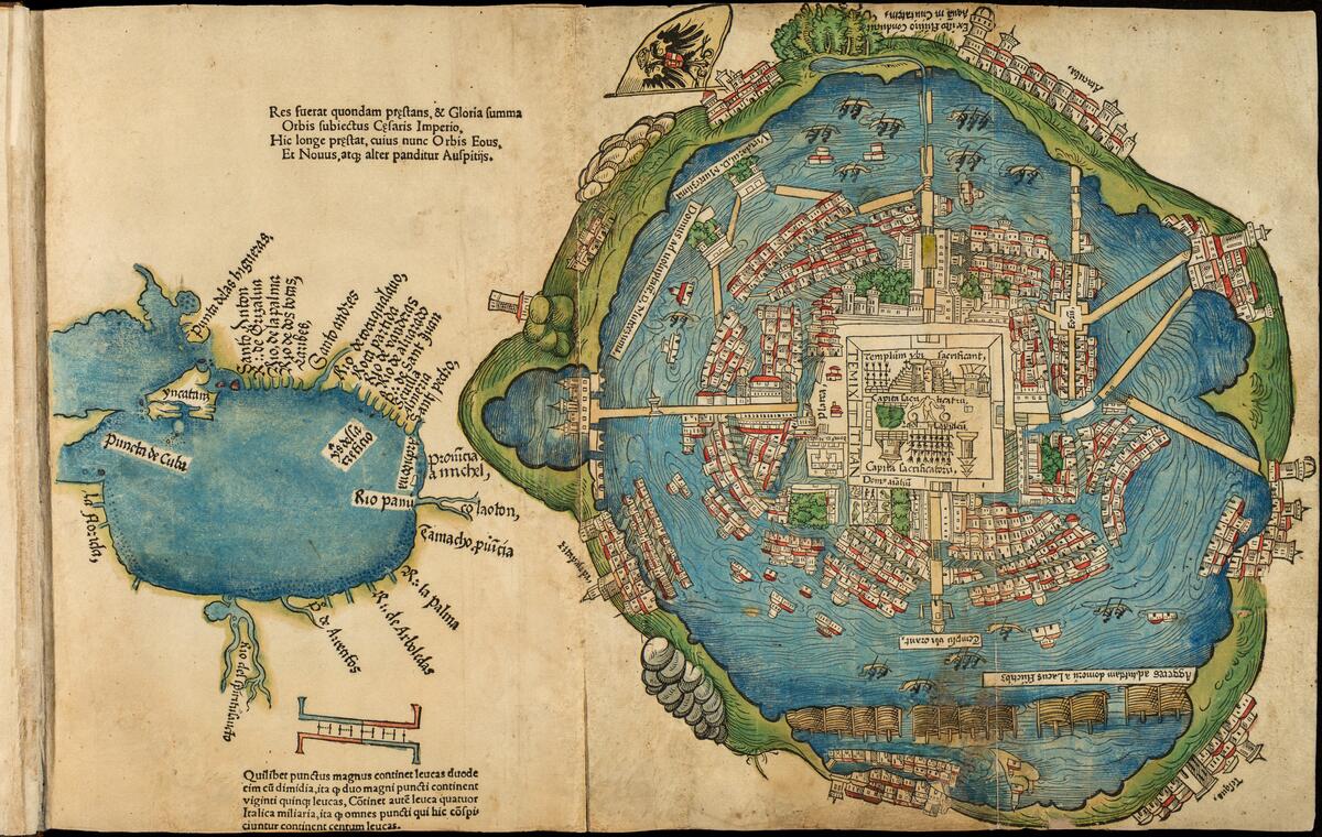
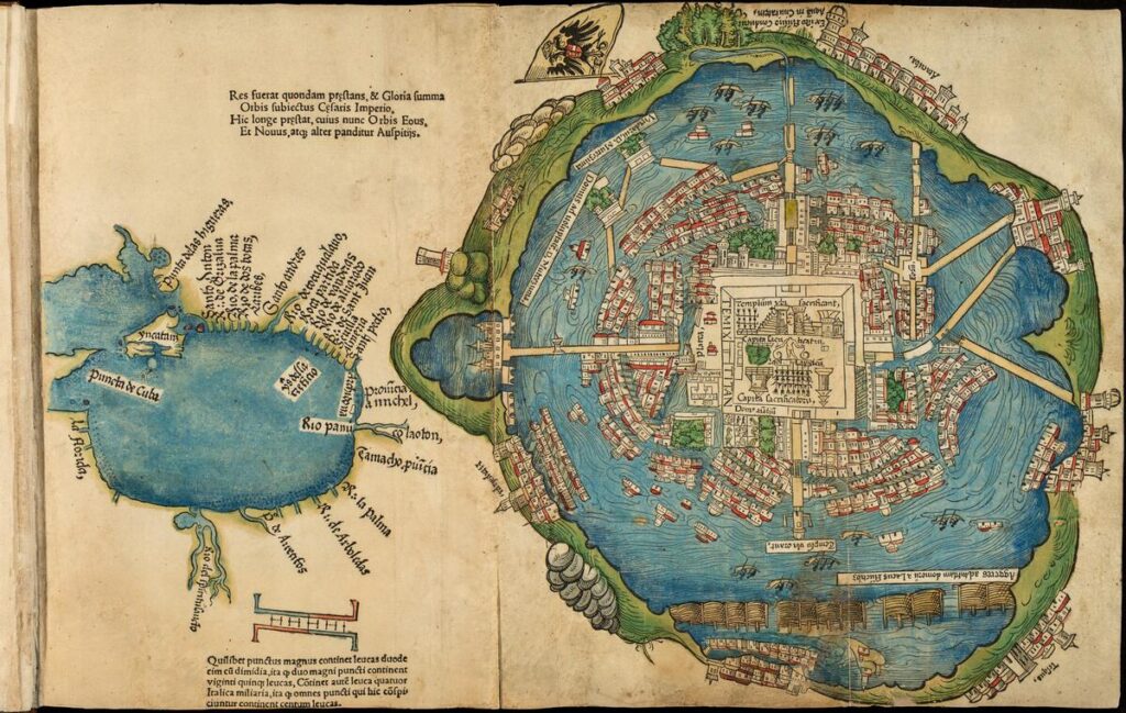
Hand-colored woodblock print of Tenochtitlan, showing it as a well-planned city in the middle of a lake. The core of the city is a rectangular plaza, surrounded by islands with houses. Causeways connect the city to the shore, and other settlements ring the lake.

Accounts of Tenochtitlan

Themes
Aztec Empire
Mexican History
New Spain
Tenochtitlan City

Periods & Events
16th Century
Spanish-Aztec War

Skills & Document Types
Close Reading
Maps
Letters
Source Comparison
Visual Literacy

Overview & Instructional Use

In this lesson for introductory-level high school students, students will compare two depictions of Tenochtitlan from a letter by Hernán Cortés—a woodcut map and written descriptions—to consider how different types of sources overlap in some ways and diverge in others.

It can be used:

  • To practice close reading and visual literacy within a history curriculum.
  • As an introduction to the Aztec Empire and the Spanish conquest.
  • As part of a lesson on the Spanish Empire and Charles V through the Extension Activities.
Materials

Procedure

  1. Map Analysis: Display the map of Tenochtitlan, and give students time to observe and discuss.
  2. Close Reading: Distribute translated excerpts of Cortés’ descriptions of the city, and give students time to read and generate questions.
  3. Compare: Prompt students to compare the visual and textual descriptions.
  4. Bring in the background information below when it is most relevant to students.
  5. Optional Extensions: Analyze the entire bound collection of Cortés’ letters, including the coat of arms of Charles V and a portrait of Pope Clement VII, to discuss the European context of the book.
Introduction

You and your students will look at parts of a letter addressed to the Spanish King Charles V from the explorer Hernán Cortés. Among other things, the letter describes one of the most significant events of the sixteenth century: the Spanish encounter with the Aztec Empire in the territory now known as Mexico. 

Its contents are also well known because it has an unusual form; it is an extended text illustrated with several important woodcuts, including a map of Tenochtitlan. The letter’s form and style might be a surprise to your students.

Note on Terminology: Many distinctive Indigenous populations inhabited the lands we now know as Mexico at the beginning of the sixteenth century. The most dominant of these groups was the Mexica, from which the name of the country would later be derived. The Mexica are more widely known today as the Aztecs, the term that will be used here.
Step 1: Map Analysis
  1. Display or distribute the map print.
  2. Explain to students that after Spanish troops invaded the Aztec Empire, Cortés wrote a letter to the King of Spain, published with this printed map, describing what they encountered in the land we today know as Mexico. While the land was new to Europeans, it was well-settled by Indigenous peoples. Reference the background information below as needed.
  3. Have students look closely at the woodcut print and describe what they see.
  4. Discuss their observations, using the discussion questions below as desired.
  5. If desired, have students record their observations on the student worksheet.
Hand-colored woodblock print of Tenochtitlan, showing it as a well-planned city in the middle of a lake. The core of the city is a rectangular plaza, surrounded by islands with houses. Causeways connect the city to the shore, and other settlements ring the lake.
Map of Tenochtitlan and surrounding areas in Praeclara Ferdinandi Cortesii de noua maris oceani Hyspania narratio (Remarkable account of Ferdinand Cortes regarding the new ocean sea of Spain) (1524)

Details

Start with the letter’s most famous element: the earliest surviving depiction of the Aztec capital city of Tenochtitlan. It offers an alluring glimpse of something otherwise buried by conquest, environmental change, and time. Sometimes the map is described as the Nuremberg map (for its place of production, now part of Germany) or the Cortés Map.

A close examination of the print will allow you and your students to talk about Tenochtitlan and consider what it might have looked and felt like before the European invasion.  

The smaller map on the left shows labeled places, including rivers, along the coastline. The larger map on the right gives the name to this print, since it represents the city of Tenochtitlan, as seen through Spanish eyes. The space between the two maps on this single page is not intended to show the accurate distance between the coastline and the landlocked Tenochtitlan, which is approximately 423 kilometers (or 263 miles) inland.

Discussion Questions
  • This print shows two different kinds of maps, one on the left, and one on the right. Describe how the two maps are different, not just in their size and shape, but the kinds of things that they depict.  
  • Look carefully at the writing in different places on the print. Can you recognize any words? Does this help identify what is being mapped?  
  • The map on the right is larger and shows a birds-eye view of Tenochtitlan. Judging from the image, what are some of the city’s main characteristics?  
  • A map of a city is not the city itself, but instead someone’s idea of what the city might look like. Do you think that this map could be an accurate depiction of the city? Why or why not? How would we know?  
  • Given that the map of Tenochtitlan is pictured from above, how would the artist have made this map five hundred years ago, before air travel?  
  • How is this map like other maps that you are familiar with? What stands out as distinctive or unusual in this view of the city?  
  • The actual city represented in this print was designed and built by Aztec people. What kinds of choices and challenges can we imagine they faced as they developed this city?  
  • What do you think it might feel like to live in and move around a city like this?  
  • What are some reasons that could explain why the map was made? What are some reasons that explain why the map might have been published in Europe?  
  • This map is a woodcut print. Does anyone know what a woodcut is? Can you imagine how you would make a woodcut and turn it into an image like this? What steps would be taken? What is the benefit of using a woodcut to make a print, instead of just painting or drawing an image? (The original woodcut was executed in simple black ink, but the one in the Newberry’s collection was also painted with various colors, which makes it particularly special.)  
  • What else do you want to know about the map? What new questions does it raise for you?
Step 2: Close Reading
Page of printed text in a modern book reading, "Cortes' Account of the City of Mexico: From his second Letter to the Emperor Charles V. In order, most potent Sire, to convey to your Majesty a just conception of the great extent of this noble city of Temixtitan [Tenochtitlan], and of the many rare and wonderful objects it contains; of the government and dominions of Muteczuma [Montezuma], the sovereign; of the religious rites and customs tha prevail, and the order that exists in this as well as other cities appertaining to his realm: it would require the labor of many accomplished writers, and much time for the completion of the task. I shall not be able to relate a hundredth part of what could be told respecting these matters; but I will endeavor to describe, in the best manner in my power, what I have myself seen; and imperfectly as I may succeed in the attempt, I am fully aware that the account will appear so wonderful as to be deemed scarcely worthy of credit; since even we have seen these things with our own eyes, are yet so amazed as to be unable to comprehend their reality. But your Majesty may be assured that if there is any fault in my relation, either in regard to the present subject, or to any other matters of which I shall give your Majesty an account, it will arise from too great brevity rather than extravagance or prolixity in the details; and it seems to be but just to my Prince and Sovereign to declare the truth in the clearest manner, without saying any thing that would detract from it or add to it."
Hernán Cortés, second letter to Charles V, (translated 1896)
  1. Distribute the excerpts and give the students enough time to read them carefully. The class could work on these excerpts individually, together and sequentially, or groups. The student worksheet has close reading questions for each excerpt.
  2. Come together as a class or in small groups to share observations, using the discussion questions below as desired. If students worked in groups, they could take turns presenting their findings to other groups or the entire class.
Details

Next, students will read translated excerpts from the letter to the Spanish king, in which Cortés describes with wonder what he encounters upon entering the city.

This text is a translation of Cortés’ description of Tenochtitlan, which he calls “Temixtitlan,” and portrays a vibrant capital city. He mentions the name of the emperor in power at the time, Moctezuma, which he spells “Muteczuma.”

These excerpts begin by addressing the Spanish king. Then the first focuses on general descriptions of the city, while the second describes the enormous market where commerce and social lives are intertwined in public view.  

Discussion Questions for Excerpt 1: Cortés’ Description of the City
  • Identify some of the details mentioned in the above excerpt that we can see represented in the map of Tenochtitlan that you have already looked at.  
  • Cortés mentions several Spanish cities—Seville, Granada, and then Salamanca in the next excerpt. In a different section, he recalls the Italian city of Venice. Why do you think he compares Tenochtitlan to these European cities?  
  • What comments suggest that Cortés was impressed by what he saw?  
  • This description emphasizes the water that surrounds the island; what are some advantages to building a city in the middle of a lake? What are some possible disadvantages?  
  • Do you think Cortés’ description of the city is accurate? Is there anything you think he might have left out? 
  • Does this excerpt answer any of your questions about the map? Does it raise any new questions?
Discussion Questions for Excerpt 2: Cortés’ Description of the Marketplace
  • Discuss the description of the market, which Aztecs called tianquiztli in Nahuatl (is anyone familiar with the word tianguis, which is still used today? Tell the class!). From the description of goods for sale there, what can we understand about the way people ate and otherwise lived?  
  • What items described are you familiar with from your own diet?  
  • What other things happen in or around the market? What kinds of people and activities are described besides the selling of goods? 
  • Do you think Cortés’ description of the market is accurate? Is there anything you think he might have left out? 
  • Did anything in this description surprise you? 
  • What are some of the indications in this excerpt and the previous that Tenochtitlan was a highly organized and structured city?   
  • What else would you like to know about Tenochtitlan?
Step 3: Comparison

Now, the students should be able to compare the visual information offered by the map with the textual descriptions, demonstrating how different forms of documentation can overlap in some ways and diverge in others. The class might also discuss the sophistication of Aztec culture and its distinctive attributes.  

  1. Ask students to put the maps and the excerpts side-by-side and compare the kinds of information they pulled out of each.
  2. Discuss how different kinds of sources provide information in different ways. This could also be a good time to bring in the background information below, other information about the scale and sophistication of the Aztec Empire, or students’ prior knowledge, if appropriate. 
Comparison Discussion Questions
  • Can you identify things described in the excerpts on the maps? 
  • What kind of information did the maps give you? What kinds of information did the excerpts give you? 
  • Which source, the map or the description, do you think was most informative? Why? 
  • What are some of the indications in the map and the excerpts that Tenochtitlan was a highly organized and structured city?  
  • What would you like to know about Tenochtitlan that isn’t depicted in the map or the excerpts? Why do you think these things were left out of both sources? 

Background

At the beginning of the sixteenth century, the lands that we now know as Mexico were inhabited by various Indigenous populations. The most dominant of these groups was the Mexica, from which the name of the country would later be derived. The Mexica are more widely known today as the Aztecs, the term that will be used here. The Aztecs were imperialists who controlled territories stretching from Central Mexico into Central America. There were, however, pockets of resistance where distinctive Native populations fought to maintain their sovereignty against the dominant Aztecs. This included the areas of Michoacan, home to the massive kingdom of the Purépecha (also known as Tarascans), second in size to the Aztec Empire, and Tlaxcala, a republic that was engaged in a perpetual war with the Aztecs.  

For two hundred years, from approximately 1325 to 1521, the Aztec Empire was led by a succession of kings who worked to continuously expand their vast control of territory. Those kings developed and ruled from their capital city called Tenochtitlan, which translates from their language of Nahuatl into “place of the nopal cactus.” The place sign for Tenochtitlan is still visible in the center of Mexico’s national flag. Tenochtitlan was located where Mexico City sits today, in the highland valley in the center of the country. In contrast to the present geography, however, the valley was dominated by a set of interlocking lakes. Tenochtitlan was an island situated in the middle of the largest one, Lake Texcoco. One of the most remarkable aspects of the Aztec capital was its engineering, since its designers developed not only a dam to keep salty water away from the island, but also causeways to allow passage to the mainland. Most importantly, the Aztecs innovated a form of raised agricultural plots, called chinampas, which expanded Tenochtitlan’s farmable lands. By the early sixteenth century, the population is estimated to have been between 150,000 to 200,000 people, a size that surpassed most European cities at the time.  

In 1519, European ships arrived on the Mexican coastline in a place they called Veracruz, or “True Cross,” since they sailed under the banner of Christianity. These were Spaniards whose religious identity as Roman Catholics fueled and justified their desire to capture and convert the people they encountered. These soldiers were led by a man named Hernán Cortés (sometimes written as Hernando or Fernando Cortés). Their unexpected and unwelcome arrival spelled the beginning of a devastating new era for Native populations in the territory, and the beginning of the end of Aztec dominance. Cortés and his men made their way inland towards the Aztec capital, building alliances with other Indigenous people who both regarded the Aztecs as enemies and felt safer siding with the Spanish. After the long trek inland, Cortés and his soldiers first glimpsed the capital city of Tenochtitlan, which surprised and impressed them. 

 In 1520, Cortés wrote an extended letter to the Spanish King Charles V, Holy Roman Emperor, to detail his findings. The letter was published in Europe as a book in 1524, where it became a best-seller. Today the most famous element of this carefully bound letter is the print that presents us with the earliest known depiction of the Aztec capital city of Tenochtitlan. Additional prints include an intricate depiction of Spanish heraldry and a profile portrait of the Pope.   

These were some of Cortés’ first steps in laying claim to the lands which were rich in both people and material goods. Often referred to as the Spanish Conquest, but also described as the Spanish-Aztec War, the two-year invasion and siege resulted in the fall of Tenochtitlan in 1521. By the time Cortés’ letter was published in Latin in 1524, Spaniards were actively building a new European-style capital in Tenochtitlan’s place. Seated directly on top of the remains of Tenochtitlan, Mexico City was now the center of what the Spaniards called New Spain (1521-1821). 

Extension Activities

The map and letter were bound together in a 1524 book, one of the first ways Cortés’ observations circulated to the European public.

You could encourage your students to begin or end the lesson by leafing through at least the first few pages to see how the text and images are presented together. The letter’s form and style might be a surprise to your students.

Exploring other illustrations in the book will help students understand the Spanish Empire and the context of the letter’s publication.
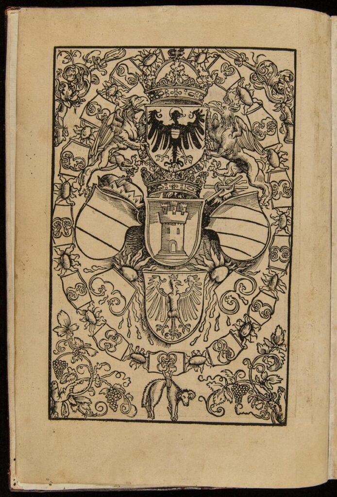
Heraldry of Charles V
Black-and-white woodblock print of the arms of Charles V, Holy Roman Emperor
Arms of Charles V in Praeclara Ferdinandi Cortesii de noua maris oceani Hyspania narratio (1524)

This print is the first image in the book through which Cortés’ letter circulated to the European public in the 1520s. It shows the heraldry, or family coat of arms, of the king of Spain, who had recently been crowned the Holy Roman Emperor. Becoming emperor meant that his domain extended well beyond Spain to include Germany, Austria, northern Italy, as well as the Southern Italian kingdoms of Naples, Sicily, and Sardinia.

In some ways the heraldry is like a portrait of the king but made from significant political and religious symbols instead of an image of his face. It includes imagery related to the Order of the Golden Fleece, a group of knights identified with chivalric or polite society, since the king belonged to that order. The symbol for the Order of the Golden Fleece is the dangling lamb at the bottom of the image. Explore more of the symbols in the heraldry here.

Consider the fact that Cortés’ letter was written in 1520, while the prints for the book were made in 1524.  
Discussion Questions
  • This print is all about the king. But why not use a simple portrait of the king, instead? How is this different or maybe even better than an actual depiction of the man himself?  
  • Why do you think that for the publication of the letter, they added this image that refers to the Spanish king? What does the letter have to do with the king? Why would the king want to be associated with the letter?  
  • What forms and symbols do you see in the print?  
  • Which details might refer to the king’s power?  
  • What details would you include in your own heraldic print?  
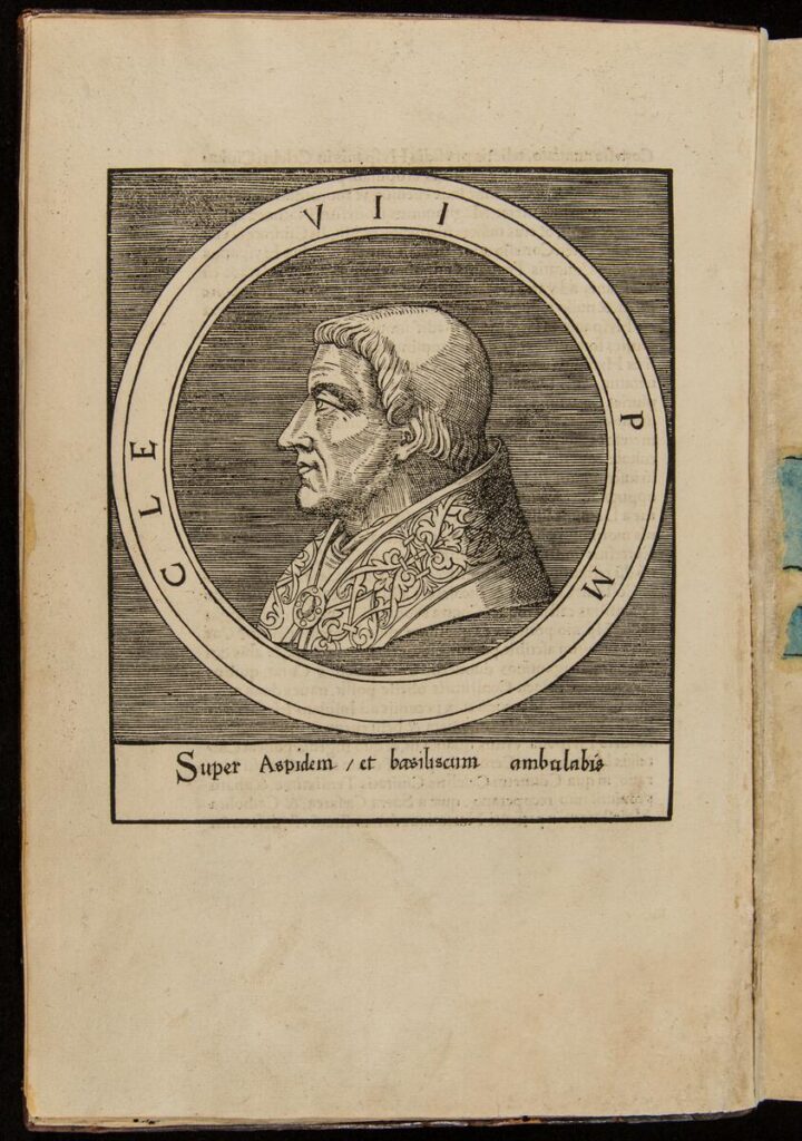
Portrait of Pope Clement VII
Black-and-white woodblock portrait of Pope Clement VII. He is a white man depicted from the shoulders up in profile, looking left. He wears a robe with a richly decorated collar pinned in front with a broach.
Portrait of Clement VII in Praeclara Ferdinandi Cortesii de noua maris oceani Hyspania narratio (1524).

This print shows a profile view of the pope, the head of the Catholic church. His portrait is based on an engraving by the Italian artist Marcantonio Raimondi. Pope Clement VII (in office 1523-1534) had just become pope at the time of the publication of Cortés’ letter in 1524. In addition to his name referenced in the round frame (roundel), we see the letters P and M, referring to “Pontifex Maximus,” or ‘supreme pope’ in Latin, the language of the church at this time. The shape of this portrait reminds us of commemorative medals that were popular at the time.

The horizontal inscription at the base of the portrait reads: “Super Aspidum/et basiliscum ambulabis” (“You will walk above the asp and basilisk”). This refers to Christ’s victory over Satan, and in this case, extends to the idea that under the pope’s guidance, Catholicism will battle New World idolatry. The same year that Cortés’ letter was published with all of these prints, Pope Clement VII approved the dispatch of the first twelve Franciscan missionaries to Mexico.  

Discussion Questions
  • We often see profile portraits like this one on stamps and coins. Describe the features of this portrait. (Figure in profile, faces left, elaborate cloak, jeweled fastener, plain background, round frame, inscriptions). Why do think this form is so common? What advantages does it have? 
  • Like the map and the heraldic print, this is another woodcut. What parts would have been carved away from the wood block to create this image?  
  • Why do you think that this portrait of the pope was included in the publication of Cortés letter? What does the letter have to do with the pope?  
  • What did the Spanish entry into Mexico and control of the people who lived there have to do with the Pope or with the Catholic church? How was religion related to Spanish colonial expansion? 

About the Author

Delia Cosentino is Professor of History of Art and Architecture at DePaul University, affiliated with Latin American and Latino Studies. She specializes in the visual culture of Greater Mexico. She is co-author of Resurrecting Tenochtitlan: Imagining the Aztec Capital in Modern Mexico City (UT Press, May 2023), with Adriana Zavala, and author of Las Joyas de Zinacantepec: Arte Colonial en el Monasterio de San Miguel (Colegio Mexiquense, 2007). Cosentino has curated exhibitions on Ceramic Trees of Life: Popular Art from Mexico (Fowler Museum, 2003), Reverence Renewed: Colonial Andean Art from the Thoma Collection (DePaul Art Museum [DPAM], 2009), and Nexo/Nexus: Latin American Connections in the Midwest  (DPAM, 2016) with Bibiana Suárez (The Art School, DePaul). Dr. Cosentino has conducted numerous research projects as a Scholar-in-Residence at the Newberry Library, and has served as a co-instructor for the Newberry Library Undergraduate Seminar in 2015 and 2023. 

Illinois Social Science Standards

This lesson supports the following standards from the Illinois Learning Standards for Social Science:

Evaluating Sources and Using Evidence
  • SS.6-8.IS.2.MC: Gather relevant information from credible sources and determine whether they support each other.
  • SS.9-12.IS.4: Determine the kinds of sources that will be helpful in answering compelling and supporting questions, taking into consideration multiple points of view represented in the sources, the types of sources available, and the potential uses of the sources.
Geography
  • SS.9-12.G.5: Analyze different ways of representing geographic information in order to compare cartographers’ perspectives, biases, and goals.
History
  • SS.6-8.H.3.MdC: Detect possible biases and limitations in the historical record based on evidence collected from different kinds of historical sources by identifying the author, purpose, funding/source, type of publication/outlet, intended audience, etc.
  • SS.6-8.H.3.MC: Evaluate the validity of claims made in historical sources representing a variety of perspectives, describe the possible or actual impact(s) of sources on audiences, and determine uses or applications.
  • SS.9-12.H.10: Identify and analyze ways in which marginalized communities are represented in historical sources and seek out sources created by historically oppressed peoples.
  • SS.9-12.H.14: Analyze the geographic and cultural forces that have resulted in conflict and cooperation. Identify the causes and effects of imperialism and colonialism.

Common Core

This lesson supports the following Common Core Literacy in History/Social Science standards:

English Language Arts: History/Social Studies
  • CCSS.ELA-LITERACY.RH.9-10.1: Cite specific textual evidence to support analysis of primary and secondary sources, attending to such features as the date and the origin of the information.
  • CCSS.ELA-LITERACY.RH.9-10.2: Determine the central ideas of information of a primary or secondary source; provide an accurate summary of how key events or ideas develop over the course of the text.
  • CCSS.ELA-LITERACY.RH.9-10.9: Compare and contrast treatments of the same topic in several primary and secondary sources.

The College, Career, and Civic Life (C3) Framework

This lesson supports the following C3 Framework standards:

Dimension 2, Geography
  • D2.Geo.5.6-8: Analyze the combinations of cultural and environmental characteristics that make places both similar to and different from other places.
Dimension 2, History
  • D2.His.6.6-8: Analyze how people’s perspectives influenced what information is available in the historical sources they created.
  • D2.His.6.9-12: Analyze the ways in which the perspectives of those writing history shaped the history that they produced.
  • D2.His.8.9-12: Analyze how current interpretations of the past are limited by the extent to which the available historical sources represent perspectives of people at the time.
  • D2.His.12.6-8: Use questions generated about multiples historical sources to identify further areas of inquiry and additional sources.
  • D2.His.13.6-8: Evaluate the relevancy and utility of a historical source based on information such as maker, date, place of origin, intended audience, and purpose.
Dimension 3
  • D3.2.6-8: Evaluate the credibility of a source by determining its relevance and intended use.

Related Teaching Resources

Indigenous Chicago Project Thumbnail
Indigenous Chicago Curriculum, A custom curriculum hosted by the Newberry and centered on Chicago as a Native Place.

Created in alignment with Illinois State Standards and to support the HB1633 mandate to teach Native history.

Additional Resources on this Topic