


Themes
Indigenous History
Periods & Events
19th Century
Westward Expansion
Skills & Document Types
Image Analysis
This activity is a way to provide a lesson on visual literacy within a history curriculum as well as an introduction to or exploration of American Indian History and Westward Expansion. To review photography, you may want to begin with Skills Lesson: Types of Photographs or Skills Lesson: Dating a Photograph.
Materials – Available for Download in the Downloads Tab:
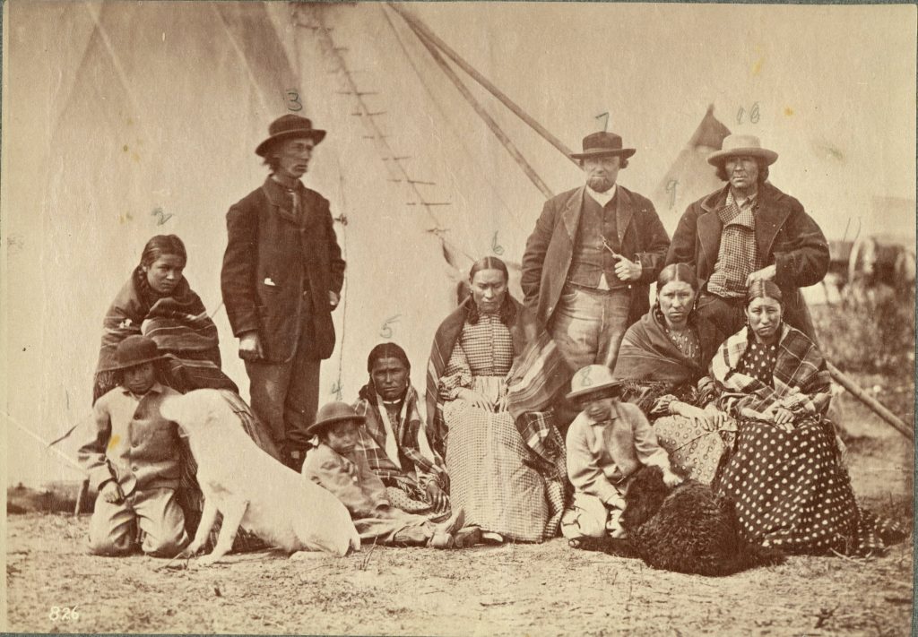
Display the image. Give students time to generate and answer questions about the photo and write notes. Consider displaying the photograph without any additional information, having students make notes. After students have spent some time with the photo, give them the caption: “Group at Fort Laramie, 1868, photo by Alexander Gardener“ and discuss how that information affects what they understand about the photo. To review the importance of captions, go to Skill Lesson: Reading a Caption. Use the background material at the end of this activity whenever you think it will encourage students to ask more questions and think more about how to engage with the image.
Click on the image for a high-resolution version that can be displayed for your class.
The Oceti Ŝakowiŋ (Seven Council Fires) people are also known as the Sioux, a name that some consider to be derogatory but others, including Siouan tribal governments, still use. The Oceti Ŝakowiŋ consist of three main groups: Eastern Dakota (Santee), Western Dakota (Nakota), and Lakota (Teton). Their historic territory covered large parts of the northern Great Plains in what is now Canada and the United States.
Located in southeast Wyoming where the Laramie and Platte Rivers meet, Fort Laramie was the largest military post in the northern Great Plains during the nineteenth century. It began in 1834 as a fur trading post called Fort William and the local Lakota people traded buffalo hides there. In 1849 the U.S. military bought the fort. By the 1860s it had become the largest and best-known military post on the Northern Plains and was the site of the signing of the 1851 Horse Creek Treaty.
In 1868, Oceti Ŝakowiŋ, Northern Arapaho, and Northern Cheyenne representatives met with the U.S. government at Fort Laramie to end Red Cloud’s War (1866-1868). In the Fort Laramie treaty, the U.S. agreed to close the Bozeman Trail, a route connecting territory in what is now Montana to the Oregon Trail, and a number of forts built to protect it. Native groups gave up ownership of a great deal of land but kept hunting and fishing rights on those lands. In exchange, they agreed to live in an area newly named the Great Sioux Reservation that would be theirs forever. The Black Hills, sacred to the Oceti Ŝakowiŋ, were part of this new reservation. Six years later, in 1874, an expedition of the U.S. military with some civilian miners went into the Black Hills and found gold. Soon more miners flooded the area. These American attempts to gain control of the Black Hills started the Black Hills War. Although the U.S. military suffered a major defeat at the Battle of Little Bighorn in 1876, the U.S. government forcibly took control of the Black Hills in 1877. This land is still contested today. Fort Laramie was finally abandoned in 1890 and became part of the National Park system in 1938.
From the Edward E. Ayer Digital Collection at the Newberry Library.
Download the following materials below: